Bagnols-les-Bains
Bagnols-les-Bains is a former commune in the Lozère department in southern France. On 1 January 2017, it was merged into the new commune Mont Lozère et Goulet.[1]
Bagnols-les-Bains | |
|---|---|
Part of Mont Lozère et Goulet | |
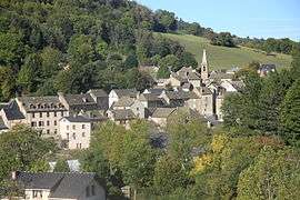 The church and surrounding buildings in Bagnols-les-Bains | |
 Coat of arms | |
Location of Bagnols-les-Bains 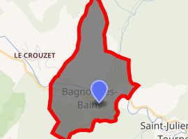
| |
 Bagnols-les-Bains  Bagnols-les-Bains | |
| Coordinates: 44°30′24″N 3°39′57″E | |
| Country | France |
| Region | Occitanie |
| Department | Lozère |
| Arrondissement | Mende |
| Canton | Saint-Étienne-du-Valdonnez |
| Commune | Mont Lozère et Goulet |
| Area 1 | 2.40 km2 (0.93 sq mi) |
| Population (2009) | 229 |
| • Density | 95/km2 (250/sq mi) |
| Time zone | UTC+01:00 (CET) |
| • Summer (DST) | UTC+02:00 (CEST) |
| Postal code | 48190 |
| Elevation | 898–1,145 m (2,946–3,757 ft) (avg. 913 m or 2,995 ft) |
| 1 French Land Register data, which excludes lakes, ponds, glaciers > 1 km2 (0.386 sq mi or 247 acres) and river estuaries. | |
Population
| Historical population | ||
|---|---|---|
| Year | Pop. | ±% |
| 1793 | 380 | — |
| 1800 | 380 | +0.0% |
| 1806 | 371 | −2.4% |
| 1821 | 402 | +8.4% |
| 1831 | 398 | −1.0% |
| 1836 | 359 | −9.8% |
| 1841 | 386 | +7.5% |
| 1846 | 397 | +2.8% |
| 1851 | 430 | +8.3% |
| 1856 | 376 | −12.6% |
| 1861 | 390 | +3.7% |
| 1866 | 417 | +6.9% |
| 1872 | 422 | +1.2% |
| 1876 | 416 | −1.4% |
| 1881 | 470 | +13.0% |
| 1886 | 538 | +14.5% |
| 1891 | 461 | −14.3% |
| 1896 | 403 | −12.6% |
| 1901 | 408 | +1.2% |
| 1906 | 370 | −9.3% |
| 1911 | 372 | +0.5% |
| 1921 | 393 | +5.6% |
| 1926 | 369 | −6.1% |
| 1931 | 346 | −6.2% |
| 1936 | 331 | −4.3% |
| 1946 | 320 | −3.3% |
| 1954 | 246 | −23.1% |
| 1962 | 232 | −5.7% |
| 1968 | 208 | −10.3% |
| 1975 | 216 | +3.8% |
| 1982 | 240 | +11.1% |
| 1990 | 200 | −16.7% |
| 1999 | 243 | +21.5% |
| 2006 | 245 | +0.8% |
| 2009 | 229 | −6.5% |
See also
References
- Arrêté préfectoral 23 May 2016 (in French)
| Wikimedia Commons has media related to Bagnols-les-Bains. |
| Authority control |
|
|---|
This article is issued from Wikipedia. The text is licensed under Creative Commons - Attribution - Sharealike. Additional terms may apply for the media files.