B8045 road
The B8045[1] is a narrow[2] 8 mile long[3] road running south-east to north-west across the island of Lismore in the Inner Hebrides: it is by default the main road on the island.[4] An unclassified track segues into the official B road at grid reference NM817380(Co-ordinates 56º29’1"N 5 º32’45"W) and passes through remote settlements at Kilcheran, Baligrundle and Balliveolan and the spring at Killandrist before reaching the Cathedral of St Moluag at Clachan. A track westwards from the main road at this point leads to Castle Coeffin.[5] From here the road heads towards the coast through Achuran until at Stronacroibh a subsidiary forks to the left for Port Ramsay while the main road continues to hug the Lynn of Lorn before reaching the jetty for the ferry to Appin[6] at NM895462(Co-ordinates 56º33’38"N 5 º25’34"W) .
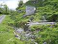 The spring at Killandrist
_-_geograph.org.uk_-_465021.jpg) The "Main" road through Achuran
The "Main" road through Achuran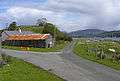 The fork to Port Ramsay at Stronacroibh
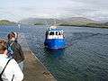 The jetty for the Appin Ferry
References
- SABRE listing
- "Geographical analysis". Archived from the original on 10 July 2011. Retrieved 15 September 2007.
- 12.874752km
- Scottish ramblers web-site
- "UK climbing web-site" (PDF). Archived from the original (PDF) on 28 September 2007. Retrieved 15 September 2007.
- Description of ride