Bévéra
The Bévéra (in French) or Bevera (in Italian) (Beura in Occitan and Ligurian) is a river of southeastern France and northwestern Italy.
| Bévéra | |
|---|---|
 | |
 | |
| Location | |
| Country | France, Italy |
| Physical characteristics | |
| Source | |
| • location | Maritime Alps |
| Mouth | |
• location | Roya |
• coordinates | 43°49′19″N 7°35′3″E |
| Discharge | |
| • average | 2.24 m3/s (79 cu ft/s)[1] |
| Basin features | |
| Progression | Roya→ Ligurian Sea |
Geography
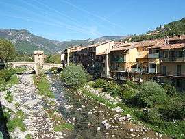
Bévéra source is in the Maritime Alps, near Moulinet in the French Alpes-Maritimes department. It flows generally southeast, through Sospel, crosses the Italian border (province of Imperia) and discharges into the river Roya, near Ventimiglia. Its length within France is 27 kilometres (17 mi). The Basséra is one of its tributaries.
Conservation
Most of the Ligurian part of Bevera valley, along with the Italian slopes of Monte Grammondo, belongs to a SIC (Site of Community Importance) called M. Grammondo T. Bevera (code IT 1315717).[2]
References
![]()
- Portate (mc) BEVERA a Torri, 1961-1970 data ot Agenzia per la protezione dell'ambiente e per i servizi tecnici, on-line: Archived 2015-07-08 at the Wayback Machine (access: July 7, 2015)
- AA.VV. "SIC IT 1315717 M.Grammondo T.Bevera - Piano di gestione" (PDF) (in Italian). Provincia di Imperia. Retrieved 2018-07-30.
External links
This article is issued from Wikipedia. The text is licensed under Creative Commons - Attribution - Sharealike. Additional terms may apply for the media files.