Avalanche Mountain
Avalanche Mountain, is a 2,861-metre (9,386-foot) mountain summit located in Glacier National Park in the Selkirk Mountains in British Columbia, Canada. Its nearest higher peak is Mount Macdonald, 2.2 km (1.4 mi) to the north. Mount Sir Donald is 3.83 km (2.38 mi) to the southeast, and Eagle Peak is 1.46 km (0.91 mi) to the south-southeast.[1] The Avalanche Glacier is situated on the east side of the peak, and the Connaught Tunnel lies partially beneath Avalanche Mountain.[4] The peak is visible from eastbound Highway 1, the Trans-Canada Highway approaching Rogers Pass. During winter and spring of each year the western slope, named Avalanche Crest,[5] generates avalanches which can threaten the highway.[6]
| Avalanche Mountain | |
|---|---|
 Avalanche Mountain (west face) seen from the Trans-Canada Highway | |
| Highest point | |
| Elevation | 2,861 m (9,386 ft) [1] [2] |
| Prominence | 280 m (920 ft) [1] |
| Parent peak | Uto Peak (2927 m)[1] |
| Coordinates | 51°17′17″N 117°28′10″W [3] |
| Geography | |
 Avalanche Mountain Location of Avalanche Mountain in British Columbia  Avalanche Mountain Avalanche Mountain (Canada) | |
| Location | British Columbia, Canada |
| Parent range | Sir Donald Range Selkirk Mountains[2] |
| Topo map | NTS 82N06[3] |
| Climbing | |
| First ascent | 1885 John Macoun, James M. Macoun[1] |
| Easiest route | Scrambling YDS 3[1] |
History
The mountain's name was applied by Major A.B. Rogers and stems from its history of avalanches from its western slopes onto Rogers Pass.[7] The 1910 Rogers Pass avalanche, the deadliest avalanche in Canadian history, resulted in the deaths of 62 Canadian Pacific Railway workers and was the impetus which forced the railway to build the Connaught Tunnel.[8]
The first ascent of the mountain was made in 1885 by John Macoun and James M. Macoun.[1]
The mountain's name was officially adopted in 1931 when approved by the Geographical Names Board of Canada.[3]
Climate
Based on the Köppen climate classification, Avalanche Mountain is located in a subarctic climate zone with cold, snowy winters, and mild summers.[9] Temperatures can drop below −20 °C with wind chill factors below −30 °C. Precipitation runoff from the mountain drains west into the Illecillewaet River, or east into the Beaver River.
References
- "Avalanche Mountain". Bivouac.com. Retrieved 2019-02-23.
- "Avalanche Peak, British Columbia". Peakbagger.com.
- "Avalanche Mountain". Geographical Names Data Base. Natural Resources Canada. Retrieved 2019-02-23.
- W., Boles, Glen (2006). Canadian mountain place names : the Rockies and Columbia Mountains. Laurilla, Roger W., 1959-, Putnam, William Lowell., Putnam, William Lowell. Place names of the Canadian Alps. Calgary, Alta.: Rocky Mountain Books. ISBN 9781894765794. OCLC 244770225.
- "Avalanche Crest". Geographical Names Data Base. Natural Resources Canada. Retrieved 2019-02-23.
- https://www.pc.gc.ca/en/pn-np/bc/glacier/activ/randonee-hiking#AvalancheCrest
- http://www.revelstokemuseum.ca/blog/2016/3/4/overwhelmed-remembering-the-march-4-1910-avalanche-at-rogers-pass
- "Rogers Pass a History of the Canadian Pacific Railway and Trans-Canada Highway crossing". cdnrail.railfan.net. Retrieved 2016-05-09.
- Peel, M. C.; Finlayson, B. L. & McMahon, T. A. (2007). "Updated world map of the Köppen−Geiger climate classification". Hydrol. Earth Syst. Sci. 11: 1633–1644. ISSN 1027-5606.
Gallery
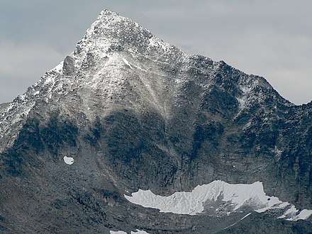 Avalanche Mountain close-up
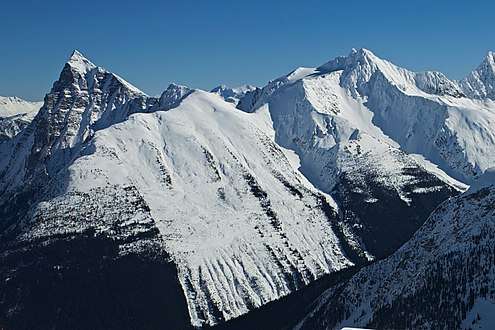 Mt. Macdonald (left) seen with Avalanche Mountain (right)
External links
- Flickr photo: Avalanche Mountain from east, with Avalanche Glacier
- Weather: Avalanche Mountain