Avacha Bay
Avacha Bay (Russian: Авачинская губа, Авачинская бухта) is a Pacific Ocean bay on the southeastern coast of the Kamchatka Peninsula. It is 24 km (15 mi) long and 3 km (2 mi) wide (at the mouth), with a maximum depth of 26 m (85 ft).[1]
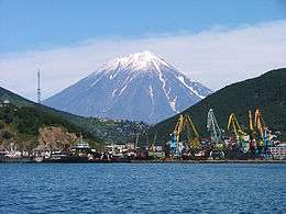

The Avacha River flows into the bay. The port city of Petropavlovsk-Kamchatsky and the closed town of Vilyuchinsk lie on the coast of the bay. It is the main transport gateway to the Kamchatka region. The bay freezes in the winter.
It was first discovered by Vitus Bering in 1729. It was surveyed and mapped by Captain Mikhail Tebenkov of the Imperial Russian Navy in the 1830s.[2]
Description
The Avacha Bay is one of the largest bays in the world able to fit any ship in the world. It is an internal part of Avacha Gulf. Total area is 215 square kilometers. Depth - up to 26 meters. Main rivers flowing into the bay - Avacha and Paratunka. It is the home base of the Russian Pacific fleet.
See also
- Tri Brata – "Three brothers", a major landmark in the bay
References
- "Avachinskaya Guba". Mapcarta. Archived from the original on 20 December 2016. Retrieved 19 December 2016.
- "Karta Kamchatskago Berega". Alaska's Digital Archives. Archived from the original on 12 November 2013. Retrieved 12 November 2013.
| Wikimedia Commons has media related to Avacha Bay. |