Ausangate
Ausangate or Auzangate[1] (in Hispanicized spellings) is a mountain of the Vilcanota mountain range in the Andes of Peru. With an elevation of 6,384 metres, it is situated around 100 kilometres southeast of Cusco in the Cusco Region, Canchis Province, Pitumarca District, and in the Quispicanchi Province, Ocongate District.[1]
| Ausangate | |
|---|---|
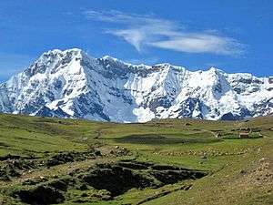 The western face of Ausangate Mountain | |
| Highest point | |
| Elevation | 6,384 m (20,945 ft) |
| Prominence | 2,085 m (6,841 ft) |
| Isolation | 245.69 km (152.66 mi) |
| Coordinates | 13°47′19″S 71°13′52″W |
| Geography | |
 Ausangate Peru | |
| Location | Cusco Region, Peru |
| Parent range | Andes, Vilcanota mountain range |

The mountain has significance in Incan mythology.
Every year the Quyllur Rit'i (Quechua for "star snow") festival which attracts thousands of Quechua pilgrims is celebrated about 20 km north of the Ausangate at the mountain Qullqipunku. It takes place one week before the Corpus Christi feast.
The region is inhabited by llama and alpaca herding communities, and constitutes one of the few remaining pastoralist societies in the world. High mountain trails are used by these herders to trade with agricultural communities at lower elevations. Currently, one of these trails, "the road of the Apu Ausangate", is one of the most renowned treks in Peru.
The area has four major geological features, the Andean uplift formed by Granits, the hanging glaciers and glacial erosional valleys, the Permian formation with its singular colors: red, ochre, and turquoise and the Cretaceous, limestone forests.
Hiking
This region has some great remote trekking options and multi day hiking is generally done from tours departing from Cusco.
See also
Gallery
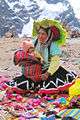 Handicraft seller in Ausangate, near Jampa Pass
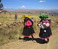 Women of Ausangate, near Tinki village
References
- escale.minedu.gob.pe - UGEL map of the Quispicanchi Province 1 (Cusco Region)