Atrato River
The Atrato River (Spanish: Río Atrato) is a river of northwestern Colombia. It rises in the slopes of the Western Cordillera and flows almost due north to the Gulf of Urabá (or Gulf of Darién), where it forms a large, swampy delta.[1] Its course crosses the Chocó Department, forming that department's border with neighboring Antioquia in two places. Its total length is about 650 km (400 mi), and it is navigable as far as Quibdó (400 km / 250 mi), the capital of the department.
.svg.png)
Flowing through a narrow valley between the Cordillera and coastal range, it has only short tributaries, the principal ones being the Truando, the Sucio, and the Murrí rivers. The gold and platinum mines of Chocó line some of its confluence, and the river sands are auriferous.[1] Mining and its toxic leavings have adversely affected river and environmental quality, damaging habitat for many species and affecting the ethnic groups: the predominately Afro-Colombian and Native American indigenous peoples who live along the river. The river is one of the only ways to move around in the Chocó region.
Northwestern Colombia encompasses an area of great diversity in wildlife. During the Pleistocene era at the height of the Atrato river, where it intersected the Cauca-Magdalena, the area was covered by a sea. It is proposed that this created a geographic barrier that may have caused many species to diverge through the process of allopatric speciation.[2] For example, Philip Hershkovitz proposed that the cotton-top tamarin (Saguinus oedipus) and the white-footed tamarin (Saguinus leocopus) diverged because of the rise of the Atrato, and today they are principally separated by the river.[2]
 The Atrato River
 View from a side branch, in the Medio Atrato region
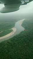 The river seen from above, Medio Atrato region.
History
In the 19th and early 20th centuries, the San Juan and the Atrato rivers attracted considerable attention as part of a feasible route for a trans-isthmian canal in Colombia.[1] William Kennish, an engineer and inventor from the Isle of Man and Royal British Navy veteran, proposed an aqueduct making use of the Atrato River and its tributary, the Truando River, to cross the Colombian isthmus. After publishing a report in 1855 on this proposal for a New York firm, he was chosen to guide a US military expedition to explore and survey the proposed project in Colombia.[3] [4] In the early 20th century, the United States built the Panama Canal instead.
In November 2016 the Constitutional Court of Colombia ruled that the Atrato River basin possesses rights to "protection, conservation, maintenance, and restoration." This ruling came about as a result of degradation to the river basin from mining, which has adversely affected nature and harmed Afro-Colombian and Indigenous peoples and their cultures. The court referred to the New Zealand declaration of the Whanganui River as a legal person holding environmental personhood. The court ordered that joint guardianship would be undertaken in the representation of the Atrato River basin. Similarly to the New Zealand declaration, the representatives would come from the national government and the Indigenous peoples living in the basin.[5]
References
-

- Hershkovitz, P (1977). Living New World Monkeys (Platyrrhini): with an introduction to Primates.
- Stimpson, Robert (2011). William Kennish Manninagh Dooie - True Manxman (1st ed.). Ramsey, Isle of Man: Lily. ISBN 9781907945083.
- "Interoceanic river aqueduct connecting the Pacific and Atlantic Oceans: [Colombia] (map)". Library of Congress. 1855?. Retrieved 6 April 2020. Check date values in:
|date=(help) - "Press Release: Colombia Constitutional Court Finds Atrato River Possesses Rights". CELDF (Press release). 2017-05-04. Retrieved 2019-03-25.