Ashdod-Sea
Ashdod-Yam (lit. "Ashdod on the Sea" in Hebrew) is an archaeological site on the Mediterranean coast of Israel. It is located in the southern part of the modern city of Ashdod, and about 5 kilometres northwest of Tel Ashdod where Ashdod stood in the time of the Philistines. Ashdod on the Sea and (inland) Ashdod were for most of their history two separate entities, connected though by close ties with each other. At different times in history one of the two twin towns would gain the upper hand over the other. There is more on the two towns and their interaction in the Ashdod article.
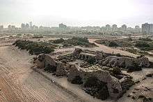


Most of the area has not been excavated yet and is covered by sand dunes.
History
The two towns, Ashdod and Ashdod-Yam, have been connected throughout their history. Despite the antiquity of the place, the name Ashdod-yam was applied to the site and adjacent town in October of 1955, by Israel's Government Naming Committee.[1]
Late Bronze Age
During the Late Bronze Age the inland city of Ashdod used a port facility near the mouth of the Lakhish River, at Tel Mor, as its main exit to the sea, while a smaller port was probably located at Ashdod-Yam.[2]
Iron Age
During the Iron Age the roles gradually reversed, and Ashdod-Yam, located south of Ashdod, overtook in importance the port at Tel Mor, located north of Ashdod. As one of the main five cities of the Philistine Pentapolis, Ashdod had great regional significance.[2]
Ashdod-Yam is first mentioned in documents from the time of Sargon II of Assyria when in 713 BCE the Assyrian king speaks of having to depose a usurper who had taken over control of the city of Ashdod and had fortified three towns: Ashdod itself, Gath, and "Asdudimmu" (Ashdod-Yam).[2]
Hellenistic through Byzantine period
When general Pompey restored to Ashdod its independence previously lost to the Hasmonean king John Hyrcanus, the city consisted of two twin towns, the regional center of Azotos Mesogeios or A. Hippenos (lit. "inland Ashdod" and "Ashdod of the horsemen" respectively), and Azotos Paralios (lit. "coastal Ashdod"; also written A. Paralus, Paralius) [3] The town, under its Greek designation, appears in the Madaba Map of the 6th century.
This arrangement persisted throughout the Byzantine period, when the port town actually overshadowed in importance its former mother-city further inland: the bishops of Azotos present at the Church councils of 325-536 seem to have resided in Azotos Paralios rather than in Azotos Mesogeios.[2][4] Remains from Azotos Paralios of the Byzantine period, including a large church, were found over 2 km north of the inland Iron Age site.
A chancel screen from a synagogue from the 6th century CE testifies to the existence of a Jewish community at Ashdod-Yam during the Byzantine period.[4]
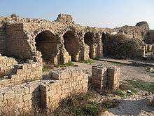
Early Muslim, Crusader, and Mamluk periods
The fort of "Minat al-Qal'a" (lit. "the port with the castle" in Arabic) was probably built by the Umayyads and was reconstructed by the Fatimids and Crusaders. The initial purpose was to hold off the strong Byzantine navy and it constituted one link in a chain of Muslim coastal fortifications.
Documents from the Crusader period indicate that Ashdod, including its port, belonged to the lordship of Ramla, and it appears probable that in 1169 the old Arab sea fort (Minat al-Qal'a) was given by Hugh, lord of Ramla, to his knight Nicolas de Beroard. From this period the fort is known as Castellum Beroart.[5]
Excavation
The Iron Age site was excavated by Jacob Kaplan from 1965 to 1968 on behalf of the Tel Aviv-Jaffa Museum of Antiquities. Finds at the site include sections of city fortification walls and a glacis. Pottery found at the site suggests that the fortifications were built in the second half of the 8th century BCE and that a second phase of occupation occurred during the 7th century BCE when the site was no longer fortified.
The medieval fort has been most recently worked on by Dov Nachlieli and his team.[6]
In 2012, a survey of Tel Ashdod was conducted by Paran Nir-Shims on behalf of the Israel Antiquities Authority (IAA).[7]
Further reading
- H. Tadmor, Journal of Cuneiform Studies 22 (1958): pp. 70–80
- J. Kaplan, Israel Exploration Journal 19 (1969): pp. 137–149
- L. Y. Rahmani, Israel Exploration Journal 37 (1987): pp. 133–134.
- The New Encyclopedia of Archaeological Excavations in the Holy Land. Jerusalem: The Israel Exploration Society and Carta: pp. 102–103
See also
- Ashdod, the historic twin city of Ashdod on the Sea; modern Ashdod now includes Ashdod on the Sea
- Minat al-Qal'a, the Early Muslim castle at Ashdod on the Sea
References
- Wikimedia Commons: Letter dated 27 Oct 1955, from the Department of Housing, in Israel's Ministry of Labor (in Hebrew)
- "Introducing Ashdod-Yam: History and Excavations". Ashdod-Yam Archaeological Project, website of. The Institute of Archaeology of Tel Aviv University, Institut für Alttestamentliche Wissenschaft Universität Leipzig. 2014. Retrieved 24 May 2015.
- Avraham Negev and Shimon Gibson (2001). Ashdod (Tel). Archaeological Encyclopedia of the Holy Land. New York and London: Continuum. p. 55. ISBN 0-8264-1316-1.
- "Azotus Paralus - (Ashdod, al-Minah)". A virtual travel through the Madaba Map. Studium Biblicum Franciscanum, Jerusalem. 2000. Archived from the original on 7 March 2016. Retrieved 24 May 2015.
- Pringle, 1998, p. 72
- http://www.hadashot-esi.org.il/report_detail_eng.aspx?id=2294
- Israel Antiquities Authority, Excavators and Excavations Permit for Year 2012, Survey Permit # S-379