Ash Green Halt railway station
Ash Green Halt railway station known for a time as Ash Green, served the village of Ash, Surrey in England original route of the Alton Line which ran from London via the town of Guildford to the east.
| Ash Green Halt | |
|---|---|
| Location | |
| Place | Ash Green |
| Area | Guildford |
| Grid reference | SU902501 |
| Operations | |
| Pre-grouping | London and South Western Railway |
| Post-grouping | Southern Railway |
| Platforms | 2 |
| History | |
| 8 October 1849[1][2] | Station opens as Ash |
| December 1876 | Station renamed Ash Green |
| September 1891 | Station renamed Ash |
| 1 October 1895 | Station renamed Ash Green |
| 1 December 1926 | Station renamed Ash Green Halt |
| 4 July 1937 | Station closed |
| Disused railway stations in the United Kingdom | |
| Closed railway stations in Britain A B C D–F G H–J K–L M–O P–R S T–V W–Z | |
History
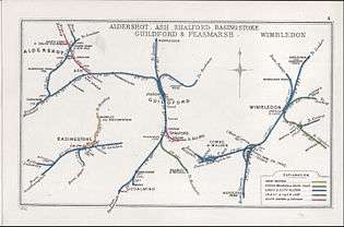
The London and South Western Railway opened the station in 1849 as a halt (request stop) between Guildford railway station and Farnham railway station before the opening of the shorter route with a line off the South Western Main Line to the north from London via Aldershot to Farnham. As a result of the 1923 Grouping, the LS&WR became part of the new Southern Railway, which closed Ash Green in 1937.
The station was renamed several times, alternating between Ash and Ash Green, with the suffix added in 1926.
The station building is now a private house, along with the Up platform.[3]
| Preceding station | Disused railways | Following station | ||
|---|---|---|---|---|
| Wanborough | Southern Railway Alton Line (Tongham branch) |
Tongham |
References
- http://www.disused-stations.org.uk/a/ash_green/
- Southern Region Record by R.H.Clark page65
- Rawlinson, Ralph (20 April 2010). "Station Name: Ash Green Halt". Disused Stations Site Record.
Sources
- Butt, R. V. J. (1995). The Directory of Railway Stations: details every public and private passenger station, halt, platform and stopping place, past and present (1st ed.). Sparkford: Patrick Stephens Ltd. ISBN 978-1-85260-508-7. OCLC 60251199.
- Jowett, Alan (2000). Jowett's Nationalised Railway Atlas (1st ed.). Penryn, Cornwall: Atlantic Transport Publishers. ISBN 978-0-906899-99-1. OCLC 228266687.
- Station on navigable 1946 O. S. map Station site at centre