Arroyo Valle
Arroyo Valle or Arroyo Del Valle[2] is a 36.4-mile-long (58.6 km)[3] westward-flowing stream that begins in northeastern Santa Clara County, California, and flows northwesterly into Alameda County where it is dammed to form Lake Del Valle. After that Arroyo Valle is tributary to Arroyo de la Laguna which in turn flows into Alameda Creek and thence to San Francisco Bay. In the past, the Arroyo Valle had a significant steelhead migration; however, degradation of the stream in the latter half of the 20th century has decimated this anadromous fish population. [4]
| Arroyo Valle Arroyo De Los Taunamines | |
|---|---|
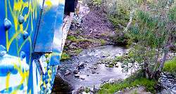
 Arroyo del Valle in Pleasanton, California | |
 Location of the mouth of Arroyo Valle in California | |
| Location | |
| Country | United States |
| State | California |
| Region | Santa Clara County |
| City | Pleasanton, California |
| Physical characteristics | |
| Source | Confluence of San Antonio Creek and Arroyo Bayo |
| ⁃ coordinates | 37°23′08″N 121°34′21″W[1] |
| ⁃ elevation | 1,808 ft (551 m) |
| Mouth | Confluence with Arroyo de la Laguna |
⁃ coordinates | 37°39′43″N 121°54′22″W[1] |
⁃ elevation | 302 ft (92 m)[1] |
| Basin features | |
| Tributaries | |
| ⁃ left | Pino Creek, Sycamore Creek (Santa Clara County), Trout Creek (Santa Clara County) |
| ⁃ right | Spring Canyon Creek, Sulphur Gulch, Colorado Creek, Dry Creek, Eylar Canyon Creek, Lang Canyon Creek |

History
Arroyo Valle was also once known as Arroyo De Los Taunamines (Stream of the Taunamines), for the Costanoan Taunamines people who lived there. In 1853 it was renamed Arroyo del Valle (Stream of the Valley).[5]
Watershed
The stream drains much of the southern portion of the city of Livermore, and it also flows through and drains a considerable fraction of the city of Pleasanton, both in the Livermore Valley. Water quality measurements in this stream indicate a pH level of 7.0, or neutral with respect to acidity; phosphate levels were not detectable.[6]
In the middle reaches of Arroyo Valle south of Livermore, there has been considerable historic grazing use. Depth to groundwater in this reach of the watershed typically ranges from 50 feet (15 m) to 100 feet (30 m) and flows to the west.[7] Subsequent to this reach, the Arroyo del Valle flows down the moderately sloping hills to enter gravel pits, where extraction (but not processing) has historically been conducted by Lone Star Industries.
Del Valle Dam forms the reservoir Lake Del Valle in southeastern Alameda County.
The upper reaches of Arroyo Valle stretch into northeastern Santa Clara County where the mainstem is formed by the confluence of San Antonio Creek and Arroyo Bayo.[8] San Antonio Creek's origin is on the western slope of 3,804 feet (1,159 m) Mount Stakes, west of the Santa Clara-Stanislaus County border, about 32 miles (51 km) southeast of Livermore. San Antonio Creek traverses the San Antonio Valley as it heads west to Arroyo Valle. Arroyo Bayo also has its origin on Mount Stakes southwestern slope and traverses Upper San Antonio Valley as it also heads west to Arroyo Valle.
References
- "Arroyo Valle". Geographic Names Information System. United States Geological Survey.
- U.S. Geological Survey Geographic Names Information System: Arroyo Valle
- U.S. Geological Survey. National Hydrography Dataset high-resolution flowline data. The National Map Archived 2012-04-05 at WebCite, accessed March 15, 2011
- Arroyo del Valle Creekwatch Archived March 3, 2016, at the Wayback Machine
- Page Mosier & Dan Mosier (1986). Alameda County Place Names. Fremont, California: Mines Road Books. p. 12. Retrieved March 12, 2016.
- Water Quality Testing in Arroyo del Valle Archived March 9, 2005, at the Wayback Machine
- Environmental Site Assessment, Murdell Lane, Unincorporated Alameda County, EMI Report 10202, September 29, 1989
- "Arroyo Bayo". Geographic Names Information System. United States Geological Survey.
External links
- Arroyo Valle northern watershed map at Oakland Museum of California
- Current conditions for Arroyo Valle at US Geological Survey; shows current and historical gage height, discharge rate, and temperature