Arno
The Arno is a river in the Tuscany region of Italy. It is the most important river of central Italy after the Tiber.
| Arno | |
|---|---|
 View of the Arno from the Ponte Vecchio | |
.png) | |
| Location | |
| Country | Italy |
| Region | Tuscany |
| Physical characteristics | |
| Source | Monte Falterona |
| • elevation | 1,385 m (4,544 ft) |
| Mouth | Tyrrhenian Sea |
• location | Marina di Pisa |
• coordinates | 43.6802°N 10.2774°E |
| Length | 241 km (150 mi) |
| Basin size | 8,228 km2 (3,177 sq mi) |
| Discharge | |
| • average | 110 m3/s (3,900 cu ft/s) (at the mouth) |
Source and route

The river originates on Monte Falterona in the Casentino area of the Apennines, and initially takes a southward curve. The river turns to the west near Arezzo passing through Florence, Empoli and Pisa, flowing into the Tyrrhenian Sea at Marina di Pisa.
With a length of 241 kilometres (150 mi), it is the largest river in the region. It has many tributaries: Sieve at 60 kilometres (37 mi) long, Bisenzio at 49 kilometres (30 mi), and the Era, Elsa, Pesa, and Pescia. The drainage basin amounts to more than 8,200 square kilometres (3,200 sq mi) and drains the waters of the following subbasins:
- The Casentino, in the province of Arezzo, formed by the upper course of the river until its confluence with the Maestro della Chiana channel.
- The Val di Chiana, a plain drained in the 18th century, which until then had been a marshy area tributary of the Tiber.
- The upper Valdarno, a long valley bordered on the east by the Pratomagno massif and on the west by the hills around Siena.
- The Sieve's basin, which flows into the Arno immediately before Florence.
- The middle Valdarno, with the plain including Florence, Sesto Fiorentino, Prato, and Pistoia.
- The lower Valdarno, with the valley of important tributaries such as the Pesa, Elsa, and Era and in which, after Pontedera, the Arno flows into the Ligurian Sea. The river has a very variable discharge, ranging from about 6 cubic metres per second (210 cu ft/s) to more than 2,000 cubic metres per second (71,000 cu ft/s). The mouth of the river was once near Pisa but is now several kilometres westwards.
It crosses Florence, where it passes below the Ponte Vecchio and the Santa Trinita bridge (built by Bartolomeo Ammannati but inspired by Michelangelo). The river flooded this city regularly in historical times, most recently in 1966, with 4,500 cubic metres per second (160,000 cu ft/s) after rainfall of 437.2 millimetres (17.21 in) in Badia Agnano and 190 millimetres (7.5 in) in Florence, in only 24 hours.
Before Pisa, the Arno is crossed by the Imperial Canal at La Botte. This water channel passes under the Arno through a tunnel, and serves to drain the former area of the Lago di Bientina, which was once the largest lake in Tuscany before its reclamation.
The flow rate of the Arno is irregular. It is sometimes described as having a torrentlike behaviour, because it can easily go from almost dry to near flood in a few days. At the point where the Arno leaves the Apennines, flow measurements can vary between 0.56 and 3,540 cubic metres per second (20 and 125,014 cu ft/s). New dams built upstream of Florence have greatly alleviated the problem in recent years.
The flood on November 4, 1966 collapsed the embankment in Florence, killing at least 40 people and damaging or destroying millions of works of art and rare books. New conservation techniques were inspired by the disaster, but even decades later hundreds of works still await restoration.[1]
Etymology
From Latin Arnus (Pliny, Natural History 3.50). The philologist Hans Krahe related this toponym on a paleo-European basis *Ar-n-, derived from the Proto-Indo-European root *er-, "flow, move".[2]
Gallery
 The Arno in Florence
 The Arno in Pisa, near the Ponte della Fortezza (Fortress Bridge)
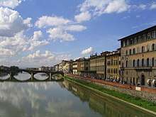
 Banks of the Arno, seen from the Ponte Vecchio (Old Bridge), Florence
 Mouth of the Arno in Marina di Pisa
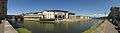 The Arno in Florence, 180 degree view: the Uffizi Gallery is straight across and the Ponte Vecchio is to the left
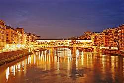
 The Arno in Florence at night
 The Ponte Amerigo Vespucci (Amerigo Vespucci Bridge)
References
- Alison McLean (November 2006). "This Month in History". Smithsonian. 37 (8): 34.
- Edelmiro Bascuas, Hidronimia y léxico de origen paleoeuropeo en Galicia (page 41)
External links
| Wikimedia Commons has media related to Arno. |
- Basin Authority of the Arno (in Italian)
| Authority control |
|
|---|