Arkansas Highway 267
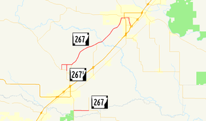
Highway 267 (AR 267, Ark. 267, and Hwy. 267) is a designation for two state highways in White County. One route of 15.47 miles (24.90 km) begins at Highway 31 and runs northeast to Highway 367 in Searcy. A second route of 2.25 miles (3.62 km) begins at Highway 31 and runs east to Highway 13. Highway 267 Spur, a spur route of 0.90 miles (1.45 km) connects Highway 267 and Highway 31 north of Beebe. The highways are maintained by the Arkansas Department of Transportation (ARDOT).
| ||||
|---|---|---|---|---|
 | ||||
| Route information | ||||
| Maintained by ArDOT | ||||
| Section 1 | ||||
| Length | 15.320 mi[1] (24.655 km) | |||
| West end | ||||
| East end | ||||
| Section 2 | ||||
| Length | 2.249 mi[1] (3.619 km) | |||
| West end | ||||
| East end | ||||
| Location | ||||
| Counties | White | |||
| Highway system | ||||
| ||||

Route description
Highway 31 to Searcy
Highway 31 to Highway 13
Highway 267 (Cypress Lake Road)[2] begins at Highway 31 in southern White County south of Beebe near Cypress Bayou Wildlife Management Area. The highway runs due east as a section line road to Highway 13, where it terminates.
Major intersections
The entire route is in White County.
| Location | mi[1][2] | km | Destinations | Notes | |||
|---|---|---|---|---|---|---|---|
| | 0.000 | 0.000 | Southern terminus | ||||
| | 1.50 | 2.41 | AR 267S northern terminus | ||||
| | 2.29 | 3.69 | AR 321 northern terminus | ||||
| | 7.39 | 11.89 | |||||
| Searcy | 13.53– 13.57 | 21.77– 21.84 | officially designated exception | ||||
| 15.320 | 24.655 | Northern terminus | |||||
| Gap in route | |||||||
| | 0.00 | 0.00 | Western terminus | ||||
| | 2.249 | 3.619 | Eastern terminus | ||||
1.000 mi = 1.609 km; 1.000 km = 0.621 mi
| |||||||
Spur route
| |
|---|---|
| Location | White County |
| Length | 0.905 mi[1] (1.456 km) |
| Existed | 1970[3]–present |
Highway 267S (AR 267S, Ark. 267S, and Hwy. 267S) is a spur route in White County, Arkansas. Created in 1970, the highway alignment has remained unchanged since creation.[3]
Route description
The highway runs south from the parent route to Highway 31.
Major intersections
The entire route is in White County.
| Location | mi[1][2] | km | Destinations | Notes | |
|---|---|---|---|---|---|
| | 0.00 | 0.00 | Northern terminus | ||
| | 0.905 | 1.456 | Northern terminus | ||
| 1.000 mi = 1.609 km; 1.000 km = 0.621 mi | |||||
See also
References
- System Information and Research Division (2014). "Arkansas Road Log Database" (MDB). Arkansas State Highway and Transportation Department. Retrieved March 27, 2016.
- Arkansas Centerline File (GIS Map) (Map) (Updated ed.). Various. Arkansas GIS Office. October 23, 2019 [September 29, 2014]. Retrieved November 29, 2019.
- "Minutes of the Meeting of the Arkansas State Highway Commission" (PDF). Little Rock: Arkansas State Highway Commission. 1953–1969. p. 235. OCLC 21798861. Retrieved May 26, 2019.
- "Minutes of the Meeting" (PDF). Arkansas State Highway Commission. 1953–69. Retrieved November 20, 2016.
- "Minutes of the Meeting" (PDF). Arkansas State Highway Commission. 1970–79. Retrieved November 20, 2016.
- "Minutes of the Meeting" (PDF). Arkansas State Highway Commission. 1980–89. Retrieved November 20, 2016.
External links
![]()