Arkansas Highway 210
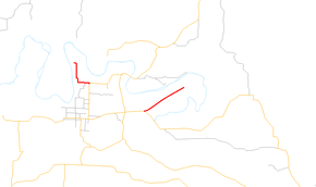
Arkansas Highway 210 (AR 210 and Hwy. 210) is a designation for two east–west state highways in Cleburne County, Arkansas. One segment of 0.82 miles (1.32 km) runs in Heber Springs from Greers Ferry Lake east to Heber Springs Road (Highway 25B) as Case Ford Road.[1][2] A second segment begins at Highway 110 and runs northeast as Industrial Park Rd.[3]
| ||||
|---|---|---|---|---|
 | ||||
| Route information | ||||
| Maintained by AHTD | ||||
| Existed | 1958–present | |||
| Section 1 | ||||
| Length | 0.82 mi[1] (1.32 km) | |||
| West end | Greers Ferry Lake | |||
| East end | ||||
| Section 2 | ||||
| Length | 2.25 mi[1] (3.62 km) | |||
| West end | ||||
| East end | Cow Shoals Ln | |||
| Location | ||||
| Counties | Cleburne | |||
| Highway system | ||||
| ||||

Route description
Case Ford Road segment
The route begins at the shores of Greers Ferry Lake and runs south to terminate at Heber Springs Road (Highway 25B). The route is two-lane, undivided for its entire length.[1]
Industrial Park Road segment
Highway 210 begins at Highway 110 and runs northeast to terminate at Cow Shoals Lane.
History
Highway 210 first appeared in the 1959 Arkansas state highway map. The route ran from Highway 110 west of Heber Springs to the northeast. The Arkansas State Highway Commission later extended Highway 210 "to provide public access to Greers Ferry Lake".[4] The segment from Heber Springs to Greers Ferry Lake was added prior to 1970.
Major intersections
The entire route is in Cleburne County.
| Location | mi[1] | km | Destinations | Notes | |
|---|---|---|---|---|---|
| Heber Springs | 0.0 | 0.0 | Greers Ferry Lake | western terminus | |
| 0.82 | 1.32 | eastern terminus | |||
| Highway 210 eastern segment begins outside Heber Springs | |||||
| | 0.0 | 0.0 | western terminus | ||
| | 2.25 | 3.62 | Cow Shoals Ln | eastern terminus | |
| 1.000 mi = 1.609 km; 1.000 km = 0.621 mi | |||||
See also
References
- Planning and Research Division (2010). "Arkansas Road Log Database". Arkansas State Highway and Transportation Department. Archived from the original (Database) on 23 June 2011. Retrieved June 9, 2011.
- Map of Heber Springs, Cleburne County, Arkansas (PDF) (Map) (July 2007 ed.). Arkansas State Highway and Transportation Department. Retrieved June 10, 2011.
- Route and Section Map (PDF) (Map) (Cleburne County ed.). Arkansas State Highway and Transportation Department. Archived (PDF) from the original on 23 June 2011. Retrieved June 10, 2011.
- "Minutes of the Meeting" (PDF). Arkansas State Highway Commission. September 27, 1967. p. 379. Retrieved May 8, 2013.
External links
![]()