Arkansas Highway 177
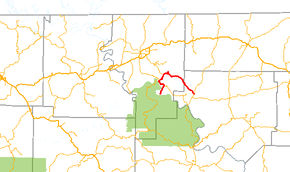
Highway 177 (AR 177, Ark. 177, and Hwy. 177) is a north–south state highway that runs in north central Arkansas. The route runs 16.20 miles (26.07 km) from Herron north over the Norfork Dam, then south to Pineville.[2][3]
| ||||
|---|---|---|---|---|
 | ||||
| Route information | ||||
| Maintained by ArDOT | ||||
| Length | 16.2 mi[1] (26.1 km) | |||
| Major junctions | ||||
| West end | Shield Lane at Herron | |||
| East end | ||||
| Location | ||||
| Counties | Izard, Baxter | |||
| Highway system | ||||
| ||||

Route description
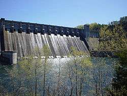
The roadway on top of the Norfork Dam is AR 177.
AR 177 begins in Herron and heads north to meet AR 5 in Norfork. It concurs with AR 5 north until Salesville. North of Salesville, AR 177 serves the Norfork National Fish Hatchery, the Quarry Cove Use Area, and bridges the Norfork Dam. The route turns south to pass through Jordan and Iuka before terminating at AR 223 in Pineville. AR 177 is a 2-lane paved highway for its entire length.[1]
Major intersections
Mile markers reset at concurrencies.
| County | Location | mi[1] | km | Destinations | Notes |
|---|---|---|---|---|---|
| Baxter | Herron | 0.0 | 0.0 | Shield Ln | |
| Norfork | 3.00 | 4.83 | |||
| Salesville | 0.0 | 0.0 | |||
| Norfork Dam | 2.56 | 4.12 | Bridge over Norfork Dam | ||
| Izard | Pineville | 13.20 | 21.24 | ||
| 1.000 mi = 1.609 km; 1.000 km = 0.621 mi | |||||
See also


References
- "[Arkansas] State Highways 2009 (Database)." April 2010. AHTD: Planning and Research Division. Database. Archived 2011-07-07 at the Wayback Machine Retrieved May 28, 2011.
- General Highway Map (PDF) (Map) (Baxter County ed.). Arkansas State Highway and Transportation Department. Retrieved May 28, 2011.
- General Highway Map (PDF) (Map) (Izard County ed.). Arkansas State Highway and Transportation Department. Retrieved May 28, 2011.
This article is issued from Wikipedia. The text is licensed under Creative Commons - Attribution - Sharealike. Additional terms may apply for the media files.