Arkansas Highway 171
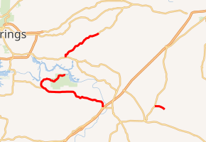
Highway 171 (AR 171, Ark. 171, and Hwy. 171) is a designation for three state highways in Southwest Arkansas. One route of 1.2 miles (1.9 km) runs from US Highway 67 (US 67) to Wine Dot Road near an industrial facility. A second route of 12.9 miles (20.8 km) begins at Highway 84 in Malvern and runs east to Lake Catherine State Park. A third route of 4.91 miles (7.90 km) begins at US Highway 270 (US 270) and runs north, with state maintenance ending at Tigre Mountain Road. All routes are maintained by the Arkansas State Highway and Transportation Department (AHTD).
| ||||
|---|---|---|---|---|
| ||||
| Route information | ||||
| Maintained by ArDOT | ||||
| Existed | c. 1939–present | |||
| Section 1 | ||||
| Length | 1.19 mi[1] (1.92 km) | |||
| South end | ||||
| North end | Wine Dot Road near Gifford | |||
| Section 2 | ||||
| Length | 11.67 mi[1] (18.78 km) | |||
| South end | ||||
| North end | Lake Catherine State Park | |||
| Section 3 | ||||
| Length | 1.27 mi[1] (2.04 km) | |||
| South end | ||||
| North end | End state maintenance at Tigre Mountain Road near Lonsdale | |||
| Location | ||||
| Counties | Garland, Hot Spring | |||
| Highway system | ||||
| ||||

History
The route was first designated on the January 1939 state highway map between Highway 84 in Malvern and Lake Catherine State Park at the county line. It was extended east deeper into the park in 1952. The segment between US 270 and the county line was added in June 1973 pursuant to Act 9 of 1973 by the Arkansas General Assembly.[2] The act directed county judges and legislators to designate up to 12 miles (19 km) of county roads as state highways in each county.[3] The final segment was added for industrial access from US 67 to a new Willamette Industries particleboard plant on March 6, 1986.[4]
Major intersections
| County | Location | mi[1] | km | Destinations | Notes | ||
|---|---|---|---|---|---|---|---|
| Hot Spring | | 0.00 | 0.00 | Southern terminus | |||
| | 1.19 | 1.92 | Wine Dot Road | Northern terminus | |||
| Gap in route | |||||||
| | 0.00 | 0.00 | Southern terminus | ||||
| Garland | Diamondhead | 7.70 | 12.39 | AR 290 eastern terminus | |||
| Hot Spring | | 11.67 | 18.78 | Lake Catherine State Park | Northern terminus | ||
| Gap in route | |||||||
| Garland | | 0.00 | 0.00 | Southern terminus | |||
| Garland–Hot Spring county line | | 4.91 | 7.90 | End state maintenance at Tigre Mountain Road | Northern terminus | ||
| 1.000 mi = 1.609 km; 1.000 km = 0.621 mi | |||||||
See also


References
- System Information and Research Division (2014). "Arkansas Road Log Database" (MDB). Arkansas State Highway and Transportation Department. Retrieved March 27, 2016.
- "Minutes of the Meeting" (PDF). Arkansas State Highway Commission. 1970–79. pp. 1191–1192. Retrieved June 15, 2017.
- Planning and Research Division, Policy Analysis Section (2010). Development of Highway and Transportation Legislation in Arkansas (PDF). A Review of the Acts Relative to Administering and Financing Highways and Transportation in Arkansas. Little Rock: Arkansas State Highway and Transportation Department. p. 13. Retrieved December 4, 2016.
- "Minutes of the Meeting" (PDF). Arkansas State Highway Commission. 1980–89. pp. 683–684. Retrieved December 4, 2016.