Arkansas Highway 119
Arkansas Highway 119 (AR 119, Ark. 119, and Hwy. 119) is a series of state highways that run in northeastern Arkansas.
| ||||
|---|---|---|---|---|
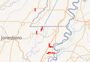
Segments of AR 119 in red, AR 119Y in blue | ||||
| Route information | ||||
| Maintained by AHTD | ||||
| Location | ||||
| Counties | Clay, Mississippi | |||
| Highway system | ||||
| ||||

Route description
Section 0
| |
|---|---|
| Location | Maria–Driver |
| Length | 5.73 mi[1] (9.22 km) |
Highway 119 is a state highway of 5.73 miles (9.22 km) that runs in Mississippi County.[1][2] It begins at an intersection with AR 14 in Maria and heads east. After 1.9 miles (3.1 km), it makes a left turn and heads north for about one mile (1.6 km) before turning due east again. It continues east for 1.7 miles (2.7 km) before turning south and ending at an intersection with US 61 in Driver.
Section 1
| |
|---|---|
| Location | Butler–Rotan |
| Length | 4.27 mi[1] (6.87 km) |
Highway 119 is a short state highway of 4.27 miles (6.87 km) that runs in Mississippi County.[1] It begins at an access road for a Mississippi River levee and runs west to an intersection at US 61 between Rotan and Driver.[2]
Section 2
| |
|---|---|
| Location | Osceola–Victoria |
| Length | 7.22 mi[1] (11.62 km) |
Highway 119 is a 7.22-mile (11.62 km) state highway in Mississippi County running from US 61 in Osceola to AR 158 near Victoria.[1] It begins at the intersection of US 61 (North Walnut Street) and West Semmes Avenue. It travels west intersecting the southern terminus of one segment of AR 325 at North Ermen Lane and the northern terminus of AR 119Y. There, it turns north, then west, and north again before crossing over I-55 and terminating at AR 158 outside the community of Victoria.[2]
Osceola spur
| |
|---|---|
| Location | Osceola |
| Length | 0.54 mi[1] (0.87 km) |
Highway 119Y is a short 0.54-mile (0.87 km) spur of AR 119 entirely in Osceola, Mississippi County. It connects an intersection of AR 140 north to section 2 of AR 119.[1][2]
Section 4
| |
|---|---|
| Location | Leachville |
| Length | 3.36 mi[1] (5.41 km) |
Highway 119 is a 3.36-mile (5.41 km) state highway entirely in Leachville, Mississippi County that runs from an intersection with AR 18 north to AR 77.[1][2]
Section 5
| |
|---|---|
| Location | Poplar Corner–Box Elder |
| Length | 5.57 mi[1] (8.96 km) |
Highway 119 is a 5.57-mile (8.96 km) state highway that runs in Mississippi County.[1] It begins at an intersection with AR 77 in Poplar Corner and heads north for about 2 miles (3.2 km) before turning east. After one mile (1.6 km), it is in the community of Buckeye and makes a left turn towards the Missouri state line. It travels north for about 2.6 miles (4.2 km) before entering the community of Box Elder and ending at the state line.[2] Missouri Supplemental Routes K and Y continue north from the state line and travel to Hornersville, Missouri.[2]
References
- State Highway Route and Section Map - Mississippi County, Arkansas (PDF) (Map). Arkansas State Highway and Transportation Department. Retrieved December 30, 2012.
- Arkansas State Highway and Transportation Department. AHTD Mississippi County map Retrieved on September 9, 2009.
- State Highway Route and Section Map - Clay County, Arkansas (PDF) (Map). Arkansas State Highway and Transportation Department. August 31, 2012. Retrieved December 30, 2012.
- General Highway Map - Clay County, Arkansas (PDF) (Map). Arkansas State Highway and Transportation Department. January 15, 1997. Retrieved December 30, 2012.
External links
