Arabian Basin
The Arabian Basin is an oceanic basin located in the southern part of the Arabian Sea between the Arabian Peninsula and India. It is centered at 10° N, 65° E.[1] The basin depth ranges from 3,400 m in the north to 4,400 m in the south, with a maximum depth of 4,652 m.[1] The floor is covered by sediments from the Indus submarine fan and is relatively smooth.[2]
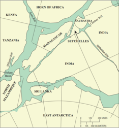

The southern enclosure of this basin is formed by the Central Indian Ridge, the Carlsberg Ridge and the Chagos-Laccadive Ridge. Bottom water enters the basin through the Owen Fracture Zone to the west.[3] The Carlsberg Ridge, at a depth of 3,800 m, separates this basin from the Somali Basin to the southwest.[1] The Arabian Basin is separated from the shallow Oman Basin by the Murray Ridge.[4] Most of the northern and eastern limits are formed by the Laxmi Ridge and the Laccadive Plateau.[2]
References
- McCutcheon, Scott; McCutcheon, Bobbi (2003). The Facts on File marine science handbook. Facts on File Science Handbooks. Infobase Publishing. p. 10. ISBN 0-8160-4812-6.
- Gupta, Rabin Sen; Desa, Ehrlich (2001). The Indian Ocean: a perspective. 2. Taylor & Francis. p. 715. ISBN 90-5809-224-0.
- Tyler, Paul A. (2003). Ecosystems of the deep oceans. Ecosystems of the world. 28. Elsevier. p. 223. ISBN 0-444-82619-X.
- Black, Kenneth D.; Shimmield, Graham B. (2003). Biogeochemistry of marine systems. Sheffield Biological Sciences. CRC Press. p. 158. ISBN 0-8493-2818-7.