Annaglogh Lead Mines
Annaglogh was one of the larger lead mines in Clontibret[1] Mining District, within County Monaghan in The Republic of Ireland.
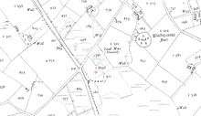
Annaglogh Mine[2] is clearly shown on the 1856,[3] 2nd edition OS map.
There is information on the mining activities in the area recorded in the Geological Survey Of Ireland Memoirs by FW Egan.[4]
Production at Annaglogh is listed in Mineral Statistics from 1852 - 1855, though the mine continued to be listed up to 1865. There were four shafts and an engine house, which are shown on the 1870 GSI Map.[5]
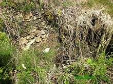
The remains of the Mines Chimney and old spoil heaps are evident, however the residence of the Mining Agent was demolished in circa 2007 and there is currently ongoing development of a new residence on the exact site (2016).
The operation was run by Captain James Skimming (1817-1880),[6] who was also the Mining Agent for the North Eastern Mining Company of Ireland which also encompassed nearby Lisdrumgormley, Coolartragh (Bond Mine), Lemgare Mines, and Hope[7] Mines[8][9] near Castleblayney.
The North Eastern Mining Company of Ireland was formed on Monday 6 April 1846 at The Angel Hotel in Liverpool[10] by way of a Shareholders meeting. The entire working capital of the company was £8000
Captain Skimming and the famous Cornish mining engineer George Henwood, were also said to be involved in a project in the West of Ireland called the Galway & Mayo United Mining Company in and around 1859-1860.[11] They were said to have extensive Mining Licences in the area which amounted to 120 square miles.
Tasson Mine[12] (1853-1867)[13] was operated by under the direction of Captain Joseph Backhouse initially.
The Castleblayney Mining Company was the operator between (1862–65) and the mine was deemed to be closed by 1867.
Lisdrumgormley was recorded in 1922 as being under development by The Farney Development Company.[14]
Captain Skimming resided in Annaglogh Castleblayney during his time in Ireland, and died here in 1880.[15] He was predeceased by his wife Elizabeth who died in 1872.[16]
Eirgrid North South Interconnector Planning Application & Oral Hearing (2016)
Eirgrid have proposed a new electricity inter-connector between Co. Tyrone and Co. Meath which crosses from Northern Ireland into the Republic at Lemgare and runs through the townlands of Lisdrumgormley and Annaglogh - all of which had extensive mining operations in them.
On Day 34 of the Oral Hearing (13 May 2016) a report & research were presented to the Hearing which was chaired by An Bord Pleanala Inspectors.
Maurice McAdam as part of his initial submission to An Bord Pleanala had raised the issue of the uncharted Mine workings in the Lemgare, Lisdrumgormley and Annaglogh area posed a series of questions to EirGrid, in particular about the research that they had carried out. Mr McAdam had questioned Eirgrid regarding the "Incurred Liability & associated costs" and the potential for harm or even death by collapse of underground Mine Workings in the area given their lax approach.
Mr McAdam, a Civil Engineering Contractor in the UK stated that the project he was currently engaged in North & South Lanarkshire had extensive Mine Workings. Extensive research and ground penetrating radar was used along with historical maps of the underground network was carried out prior to extensive grouting and rehabilitation of all known mines and shafts. All shafts were capped also. He made the point that EirGrid had not considered this scope of works whatsoever with relation to the areas of Mine workings in Lemgare, Lisdrumgormley & Annaglogh relative to their Proposed Development. .
He then introduced Dr. Colin Andrew, a Mining Geologist from Co. Meath and member of the NEPPC whom he had commissioned to carry out additional research and collate information from both his & Dr Andrew's own findings into a report- which was submitted to the Inspectors at the Hearing.
Dr Andrew reported as follows:
The northernmost portion of the proposed overhead high voltage cable alignment between proposed pylons 102 and 117 transected an area of extensive ancient and old mining activity, principally for lead. This activity dated from the medieval period but reached a maximum in the mid-19th century when a number of mines were active.
The mines were extensive although production was relatively limited due to the nature of the mineralisation forming rich pipes within the fault-vein structures. With respect to the proposed development many collapses into mine voids have been recorded over recent years both in the vicinity of known shafts and lateral workings but also in areas with no recorded mining activity. In this respect a number of proposed pylon placements are located in hazardous areas in close proximity to recent collapses. Dr Andrew said he believed the total absence of any assessment or even acknowledgement of these issues was a fundamental omission within the EIS.
Construction of such a development involves numerous access routes for vehicles up to 38 tonnes gross axle weight along tracks overlying open mine voids and the potential for danger to life and limb is paramount. The EIS is fundamentally deficient in not addressing such issues as not only access is compromised but the siting of a number of the proposed pylons has not been properly evaluated.
Evaluation should have comprised field examination of the sites, detailed mapping of the mine sites by an experienced industrial archaeologist and mining geologist followed by ground penetrating radar or similar geophysical technique to ascertain the presence of subjacent mine voids. In the view of Dr Andrew, without such the EIS remained fundamentally inadequate.
In similar terrains, in Cornwall, for example, many sudden collapses into old mine voids are commonplace and it is a normal requirement of planning from Cornwall County Council to have a full comprehensive search on mine records and ground survey completed as part of any planning application.
Location: The mines were mostly grouped round the village of Milltown, within the eastern border of Co. Monaghan, and several disused shafts bearing the names of separate townlands may occur on this long lode. The Tassan-Tonagh-Coolartragh lode is thus traceable for 3 km and workings may be expected anywhere along this feature. GSI Memoir 58 (1914) notes that "...numerous small disused shafts and workings occur along the line of the lode between Tassan and Coolartragh".
Several of the smaller ventures, not touched on here, are mentioned in Memoir 59, ‘pp. 28-9 (1877). The remains of ancient workings are seen at a point between the Lemgare and Annaglogh shafts. A ruined engine-house marks the site of a lode of galena (lead) said to range north and south, with an easterly hade, in Croaghan, south of Tassan Lough; and in Glare Oghill, at the edge of the map, nearly due west of Castleblayney, a similar lode was at one time worked. Some of the shafts here remain partly open. A lode of lead is reported to have been discovered in Grig, north-east of the last named townland, and to have been also struck near the railway bridge, south of this.
Details of individual mines
Coolartragh Mines
History: According to the GSI 6" Sheet and MSS notes, about seven shafts were opened on the vein that traverses the townland from south to north. Griffith (1861, p. 150) is the authority for identifying Coolartragh as also being known as the Bond Mine. The UK Department of Trade & Industry and the BGS .possesses a plan, and a section down to 35 fathoms, showing four levels, dated 1892 (AM 2986).
The Bond Mine operated by the Consolidated Mines of Bond, Lemgare and Lisdrumgormel (sic) Company of Liverpool under Captain John Skimming was reported in 1846 (Mining Journal) to have been developed at the 18, 25 and 30 fathom levels where the vein was large and productive with bunches of rich ore and that the vein had been explored for nearly "1 mile of length"
The engine shaft is said to have been vertical and cut the lode at 30 fathoms, and a large and valuable amount of ore is supposed to remain yet un-extracted. This lode is considered to be identical with the main Tassan Vein. It has an underlie to the east at 60o, and its course appears to have been proved beyond doubt both north and south of the main sinking. The matrix here is chiefly quartz, with some calcite; and a considerable quantity of sphalerite is said to occur along with the lead.
Tonagh Mine: History
Two small shafts were sunk close to the boundary of Coolartragh and Tonagh townlands. And some minor production ensued between 1859-61 when the vein showed a band of galena underlying to the east within a zone of brecciated slates above a footwall of Tertiary basalt. A landowner (Michael Hughes) proposed to dewater the shafts in Tonagh in 1953 but nothing came of this. No production is detailed.
Lemgare Mine: History
In the townland of Lemgare an adit and three shafts along a strike length of 50 fathoms (95m) were sunk to a depth of 18 fathoms (35m) below adit on a nearly vertical vein by the Consolidated Mines of Bond, Lemgare and Lisdrumgormel (sic) Company of Liverpool under Captain John Skimming commencing in July 1846. The vein is supposed to be the same as that at Annaglogh, located approximately 1 km to the SSE, which are marked on the MS. 6″ map of the Geological Survey. Griffith (1861, p. 150) gives Lemgare as a worked mine. Mem. 59, p. 28, regards it as on the continuation of the Annaglogh lode.
The Lemgare vein has been profitably worked at Annaglogh. It heads easterly at around 75o, and is joined from the north by another, also heading easterly at around 60o. A shaft at the junction reached rich ore at 17 fathoms (~30m). The lode is supposed to be thrown northwards by a cross-course about 1.2m wide which exists as indicated on the map, as all trace of it is lost farther to the east, it is believed to have been proved 150m farther north.
Lemgare Mine was re-opened by Billiton NV in the early 1950s as part of prospecting activities. The adit extended along an unmineralized fault zone for approximately 110m, being connected to surface by a short (4m) ventilation shaft near the portal. Upon entering sandstone wall-rocks the fault became mineralized and some stoping was seen to surface (20m) near the end of the drive which extended but was inaccessible but almost certainly extends below two surface shaft collapse located above. An inclined shaft or winze to indeterminate depth (presumably to 18 fathoms (~35m) was also located along the course of the adit with a 10 cm rib of galena on the fault plane.
Annaglogh Mine: History
This mine is known to have been in production in 1852 and features in the list of mines between 1860-65 when it was being worked by the Consolidated Mines of Bond, Lemgare and Lisdrumgormel (sic) Company of Liverpool under Captain John Skimming. During this period approximately 300-400 tonnes of ore was reported as being raised annually. The 1870 MSS 6″ map of the Geological Survey gives details of four shafts one of which was sunk as much as 40 fathoms (~75m) on the vein, and a pumping engine house. The sites of several of these, along with the base of the engine house and its associated chimney are still visible. The only output from Annaglogh is recorded in 1852 when 310 tons of lead was produced and "some lead sold" in 1853.
Tassan Mine: History
This was probably the most important mine of the district. The townland adjoins that of Tonagh on the south, and the vein is the same as that which passes northward into Coolartragh. The mine was commenced in the late 1840s by Joseph Backhouse as the Tassan Mining Company 1844-56, but the most significant period of working was by the Castleblayney Mining Company from 1856–61 and from 1862-5; but it seems to have been closed in 1867. There are five shafts marked on the 1857 6" OSI map although little trace remains of them at the present time.
Lisdrumgormley Mine: History
The 6″ Geological Survey MSS map marks two veins continuing northward from those of Annaglogh, and the western of these was reached at no great depth in Lisdrumgormley, just east of a basaltic dyke that is probably correlated with this fault / vein. In the north of the townland, close against the Armagh border, "Lead Mine" is engraved on the 6" Ordnance sheet. Lisdrumgormley was also under exploration by the Farney Development Company in 1922.
The lode in Lisdrumgormley is reported, on contemporary authority, to be still rich in argentiferous galena, embedded in a matrix of quartz and carbonate of lime in the deepest workings. so far as it is known, from 2 to 9 feet. This lode, which comes to the surface at the main working, is said to have realized a large profit at depths not exceeding 25 fathoms. A shaft located some 250m SSE along strike of the vein is reported to have attained 60m depth and returned 50 tonnes of lead concentrates.
Extent of Mine Workings
Because of a combination of the age of the mine workings for lead in this area coupled with the short-lived nature of the various formalised cost-book companies that operated the mines, the records of the extent of workings are obscure. Most of the cost-book companies were not floated on the London Stock Exchange as was common practice at this time and, as a result, did not return reports that were then published in the contemporary Mining Journal.
Dr Andrew claimed that in their assessment of the extent and impact of mine workings EirGrid had solely relied upon the information received from the GSI and EPA and did not appear to have conducted any detailed research. The GSI have admitted in correspondence concerning the extent of mine workings in the area that they “..do not necessarily capture the full extent of a feature, particularly if it is inaccessible and impractical..” and thus do not have information detailing the extent of mine workings such as shafts, trial pits, adits, stoped sections of veins and any lateral workings thereon.
It is also worth noting that the other statutory body, the Environmental Protection Agency ("EPA") have also confirmed (to Maurice McAdam) that "As per your complaint to the EPA, in relation to the EPA Inventory of Disused Mine Sites 2009, this national inventory taken does not account of every mine site but is risk based taken to define the mine waste/spoil sites, the waste geo-chemistry and to account for Public Health and Safety."
In the opinion of Dr Andrew, it appears that the two statutory bodies are unaware of the locations of mine workings and their attendant risk and EirGrid have not conducted any form of site investigation.
Recent collapses: The submitted EIS makes absolutely no reference to the two recorded occurrences of mine workings collapse in both Annaglogh and Lisdrumgormley in 2010 and 2012 respectively in any part of EirGrid’s application or supporting documents it has submitted with its application.
Risk assessment: Collapse of old mine workings results from a number of factors. Chief amongst these is heavy rainfall causing loading of the surficial materials covering the voids and resultant gravitational collapse. Raveling from the walls of the void spaces also is a contributory factor.
What is without doubt is that the principal cause is instability either from gradational collapse below the surficial plug or by surface loading which can be triggered even by the weight of an animal. Quite clearly 38 tonne trucks and excavators are very likely to cause additional collapses not only of shafts but also of stopes and other lateral workings and trials.
Specific issues are detailed in the table below:
| Proposed Pylon 102
(NI Section) |
Located on the northerly strike extension of the Coolartragh veins system. Potential for lateral development under this area. |
| Proposed Pylon 103 | Access route crosses known mine workings in close proximity to shaft on Coolartragh East Vein and the location of an ancient lead mine. |
| Proposed Pylon 108 | Located directly above adit level of Lemgare Mine, stoping to surface seen in underground surveys. Small shafts and stopes to surface seen at surface but ignored by EirGrid. |
| Proposed Pylon 109 | Located within 50m of historic collapses, access route crosses these temporarily filled collapses. Land owner aware of multiple collapses over past 50 years. Two veins worked at depth at Annaglogh Mine extend under this location from Junction Shaft sunk to the 40 fathom level (~80m below surface).
The proposed access route directly crosses the location of a former collapsed shaft that was infilled by the landowner some 30 years ago. The modified access routes dated 29 April 2016 are absurd in that they now directly cross the location of a collapsed mine working. |
| Proposed Pylon 110 | No history of collapse in this area to date but lies in close proximity to known mine workings at the Annaglogh Mine.
Access routes to proposed pylon site and guarding areas criss-cross an area of extensive mining operations, known shafts and lateral workings. |
| Proposed Pylon 116 | Located over the northern section of the Tassan Mine. Two parallel veins known to have been mined down to the 80 fathom level (~150m below surface). Likelihood of collapse of near surface stopes. Shafts on eastern vein lie both north and south of the proposed alignment.
Access routes cross an area of possible lateral underground workings. |
EIRGRID Response to Report-
EirGrid stood by the accuracy and extent of the environmental impact statement and the basis on which they had carried out the research. They said none of the new information would change their assessment which had been done with the help of GSI information and LiDAR technology to provided details of the topography.
The assessment they had already made of the Lemgare area which showed the old mine workings extending away from the area where the pylons would be going. In their response document published in December 2015 the company noted that a number of submissions raised issues in respect of the potential of the proposed development to impact on specific mines. These issues were addressed as follows:-
Tassan Mine: Details of Tassan Mine are included in the EIS. The historical mine is located 170m south east of Tower 117. The mine area of Tassan CGS was delineated by the GSI and incorporates the locations of shafts, other surface features and historical maps and data. There are no historical records that would suggest mine shafts at Tower 116 or 117. All historical data available from the GSI was assessed. The boundaries of the CGS are shown on Figure 7.17 in Volume 3C. Distances to the outlined boundary of Tassan CGS are detailed in Chapter 7, Volume 3C.
Lemgare Mine: The Lemgare mines were avoided by the route selection process, with proposed mitigation measures identified regarding Lemgare County Geological Site (CGS). Historical maps available from the GSI indicate that the underground works are contained within the boundaries of the Lemgare County Geological Site. The boundaries of the Lemgare CGS are shown on Figure 7.17 in Volume 3C. Distances from the proposed works to the boundary of Lemgare CGS are detailed in Chapter 7, Volume 3C.
Lisdrumgromly and Annaglogh Mines: Lisdrumgromly and Annaglogh Mines are located over 200m from the proposed interconnector. OSI and GSI records show the locations of shafts and surface workings for Lisdrumgromly and Annaglogh. Based on a review of the data there is no evidence of underground workings along the proposed line or at tower bases. All historical data available from the GSI was evaluated. The location of ‘collapsed shafts’ are mapped on the OSI historical maps. No evidence of mine shafts at the tower bases are presented in the submission. Based on a review of the data there is no evidence of underground workings along the proposed line or at tower bases.
The Co. Monaghan Geological Site Report on Lemgare says the site was part of a working farm and the fields immediately surrounding the mine dumps were used for grazing cattle. Many of the minerals that had been recorded there could only be studied satisfactorily with specialist equipment and the site was thus likely to be of interest mainly to scientists. Therefore it did not require further promotion. The presence of rare wulfenite meant Lemgare warranted County Geological Site status.
Conclusions of Dr Andrew's Report
Dr Andrews concluded that the EirGrid EIS is particularly remiss in failing to locate, identify and assess mine workings. The failure to recognise and assess the potential for collapse of old mine workings was a major and fundamental omission. The failure almost certainly stems from a lack of understanding of such issues, a failure to examine the sites in the field, and a total lack of site investigation of any form whatsoever other than a desk-top study. The absence of any form of appropriate assessment is total folly and is clearly unacceptable. Dr Andrew told the inspectors that permitting the project could not be granted until such on site assessment and study had been completed to an acceptable professional standard.
Other Information
James Skimming is mentioned in countless articles including;
- Ireland's Recovery (1855) John Locke [17]
- Mentioned as Mining Agent in the Nant-Y Car Mines in Wales under the ownership of BB Popplewell (1863-1872), then George (G.G,) & Mrs G Tetley (1872-1875) and finally C. W. Seccombe (1878-1893) when it was eventually wound up in 1893.[18] GG Tetley (1805 - 1873)[19] a Bradford merchant, was the Chairman and single largest shareholder of the Tasson Mine (3,000 shares out of a total of 19,856 issued).
- Extracts from the report of GL Kroll (The Pb Zn Deposits North of Castleblayney Ireland) & Mining Journal 9 April 1853 P.216 [20][21]
- The British Newspaper Archive / James Skimming Mines / Skimming Mines[22][23]
- Lemgare Mines- The British Newspaper Archive
Career Summary of Capt. James Skimming[24]
- North Eastern Mining Company of Ireland (Monaghan) Chief Agent 1846-1855
- Benree (Shropshire UK) Chief Agent 1859
- Roman Gravels (Shropshire UK) Chief Agent 1859
- White Grit, East (Shropshire UK) Chief Agent 1859
- Nant-y Car (Breconshire UK) Chief Agent 1868-1871
Mine Works Collapses in area
There was extensive mining operations in the townlands of Coolartragh,[25] Lemgare and Lisdrumgormley. In recent years there has been several instances whereby the Shaft/Tunnel networks of some of these disused mine locations have collapsed.
- Whilst ongoing Quarry Operations were being carried out in Lemgare Quarry, uncharted underground mine shafts from that of Coolartragh Mines were uncovered in early 2000.[26]
- In 2010 in Annaglogh on the property of Philip McAdam there was an instance where 2 mine shafts collapsed and these were subsequently back-filled and made safe by the DCNER. The actual works were carried out by the OPW (Office of Public Works). prior to this one of the same shafts collapsed in the late 1960s and was filled in by Monaghan County Council.
- In 2012 on the site of the disused Lisdrumgormley lead Mine, within property of James Watters there was also a shaft collapse whereby the Office of Public Works also made the area safe.
- There have been several instances where the shaft at the Mine head location (as shown on the sketch in Annaglogh) where the actual Mine's Chimney was located has collapsed throughout the 1960s and 1970s, and each time the landowner, Patrick Morgan back-filled this himself as he was quite unaware of the role of the state in making sure these shafts were safe.
References
- "www.genuki.org.uk".
- Irish Mining Prospects, Belfast News-Letter (10 November 1851). "County Monaghan Mines".
- News Letter, Saunders' (20 March 1856). "To Mining Companies or parties requiring Mining Properties".
- Egan, FW (1877). "Memoirs of the Geological Survey - EXPLANATORY MEMOIR TO ACCOMPANY SHEET 59 OF THE MAPS OF THE GEOLOGICAL SURVEY OF IRELAND" (PDF).
- "Home page | Irish historical geological maps | GSI - GSNI - BGS". www.geologicalmaps.net. Retrieved 27 January 2016.
- "familysearch.org".
- Lead Mines, County Monaghan (8 October 1859). "Northern Standard".
- "GSI" (PDF). Archived from the original (PDF) on 7 March 2016.
- "County Monaghan: Buildings of Ireland: National Inventory of Architectural Heritage". www.buildingsofireland.ie. Retrieved 27 January 2016.
- Standard, Northern (9 May 1846). "Mining in Co. Monaghan". (subscription required)
- Cork Commercial Courier, Southern Reporter and (17 October 1859). "The Mining Industry of Ireland".
- "www.gsi.ie" (PDF). Archived from the original (PDF) on 4 March 2016.
- Cole, Grenville A.J. (1922). "Memoir and Map of Localities of Minerals of Economic Importance and Mefalliferous Mines in Ireland" (PDF). Memoirs of the Geological Survey of Ireland.
- Cole, Grenville A. J. (1922). "DEPARTMENT OF AGRICULTURE AND TECHNICAL INSTRUCTION FOR IRELAND". Memoir and Map of Localities of Minerals of Economic Importance and Mefalliferous Mines in Ireland. THE STATIONERY OFFICE.
- "Family Search".
- "familysearch.org".
- Locke, John (1 January 1855). Ireland's recovery. JSTOR 60248626.
- Hunt, Robert (1 January 1870). MINERAL STATISTICS OF THE UNITED KINGDOM OF GREAT BRITAIN AND IRELAND.
- "Jane's Genealogy Pages - Newspaper article - Tetley, George Greenwood - 23 Jan 1873". freepages.genealogy.rootsweb.ancestry.com. Retrieved 27 January 2016.
- Kroll, G.L. (12 December 1862). "The Pb Zn Deposits North of Castleblayney Ireland". Cite journal requires
|journal=(help) - "Sign In". dub118.mail.live.com. Retrieved 27 January 2016.
- "Results for 'james%20skimming%20mines' | British Newspaper Archive". www.britishnewspaperarchive.co.uk. Retrieved 27 January 2016.
- "Results for '%20skimming%20mines' | British Newspaper Archive". www.britishnewspaperarchive.co.uk. Retrieved 27 January 2016.
- Exeter University. "www.exeter.ac.uk".
- Cole, Grenville A.J. (1922). "MINERAL RESOURCES. ' Memoir and Map of Localities of Minerals of Economic Importance and Metalliferous- Mines in Ireland" (PDF). Department of Agriculture and Technical Instruction for Ireland. Memoirs- of the Geological Survey of Ireland. The Stationery Office: 96–101.
- "Show Content 15658". www.biab.ac.uk. Retrieved 27 January 2016.