American Mediterranean Sea
The American Mediterranean Sea is a name for the combined watershed of the Mississippi River Basin and the waterbody of the Caribbean Sea and the Gulf of Mexico.[1] The name is not recognized by the USGS, the International Hydrographic Organization or other international hydrological bodies.
| American Mediterranean Sea | |
|---|---|
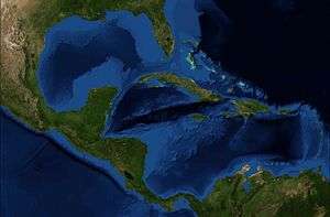 Composite satellite image of the American Mediterranean Sea | |
| Coordinates | |
| Type | Sea |
| Basin countries | Aruba, Belize, Antigua and Barbuda, Colombia, Costa Rica, Cuba, Curaçao, Dominican Republic, Guatemala, Haiti, Honduras, Jamaica, Mexico, Nicaragua, Panama, Puerto Rico, Trinidad and Tobago, United States, Venezuela, Lesser Antilles |
| Surface area | 4,200,000 km2 (1,600,000 sq mi) |
| Average depth | 2,216 m (7,270 ft) |
| Max. depth | 7,686 m (25,217 ft) |
| Islands | 1100+ |
| Settlements | Barranquilla, Barcelona, Beaumont, Cancun, Cartagena, Colón, Corpus Christi, Cumaná, Havana, Houston, Maracaibo, Miami, Mobile, New Orleans, San Juan, Santa Marta, Santo Domingo, Tampa, Veracruz |
The American Mediterranean has a surface area of 4.319 million km2 and an average depth of 2,216 metres (7,270 ft).[1]
Its basins include those of the southern Caribbean: The Venezuelan, the two Colombians, the Magdalena River and the Gulf of Darién; and the Yucatan Basin. It also contains the Mexican and the Mississippi Basin, both of the Gulf of Mexico.[1][2]
The American Mediterranean is considered one of the oceanic marginal seas. In addition to numerous small islands, large and small groups of islands, and islets, it includes the large islands of Cuba, bordering the Gulf of Mexico and the Caribbean; of Jamaica, Hispaniola, and of Puerto Rico. All of these islands are among the West Indian islands that separate the American Mediterranean from the Atlantic.
Between the islands, the American Mediterranean Sea contains the following straits: the Florida Straits, the Windward Passage (Paso de los Vientos), the Mona Passage (Canal de la Mona), the Anegada Passage to Guadeloupe Passage, the Dominica Passage to Martinique Passage, St. Lucia, and St. Vincent. Within the Mediterranean, the Straits of Yucatán to the Gulf of Mexico connect with the Caribbean, and by the Panama Canal, built in the 20th century, it is connected to the Pacific.
Watershed
The American Mediterranean Sea drains approximately 6,200,000 km2 (2,400,000 sq mi) in North America and Caribbean South America; it is the 2nd largest sea watershed. The watershed depends on South American water bodies such as the Magdalena River with 257,440 km2 (99,397 sq mi), as well as the Guajira Peninsula and the Gulf of Venezuela. Central American drainages include those of/to the Belize River, Gulf of Honduras, Caratasca Lagoon, Nicaraguan Caribbean Lowlands, and the Colorado River in Costa Rica. In North America, the sea mostly drains by the Mississippi River basin of 3,202,230 km2 (1,236,388 sq mi), to the east of the Continental Divide of the Americas, while it drains approximately 610,000 km2 (235,000 sq mi) from the Rio Grande and 198,000 km2 (76,300 sq mi) from the Yucatan Peninsula.[3]
See also
References
- Sverdrup, H. U., M. W. Johnson and R. H. Fleming; The Oceans Their Physics, Chemistry, and General Biology, Prentis-Hall, 1942, pp. 15, 35 and 637-643
- French, C. D, and C. J. Schenk, USGS Open File Report 97-470-K, Map Showing Geology, Oil and Gas Fields, and Geologic Provinces of the Caribbean Region (large PDF file)
- www.britannica.com.