Cima Altemberg
The Altemberg is a mountain in the Pennine Alps of north-western Italy; with an elevation of 2,395 m (7,858 ft) is the highest peak of the Alpi Cusiane.
| Cima Altemberg | |
|---|---|
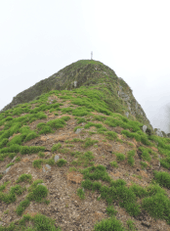
 The Altemberg as seen from Monte Capio | |
| Highest point | |
| Elevation | 2,395 m (7,858 ft) |
| Coordinates | 45°56′11″N 8°12′14″E |
| Geography | |
 Cima Altemberg Location in the Alps | |
| Location | Province of Verbano-Cusio-Ossola / Province of Vercelli, Italy |
| Parent range | Alpi Cusiane (Pennine Alps) |
| Climbing | |
| Easiest route | hiking from Campello Monti or Rimella |
Toponymy
The name of the mountain is connected to the Walser German, a language spoken by people who settled into the upper valley of the Strona and Sesia centuries ago[1]. In German Alten means old[2] while Berg means hill or mountain[3], so the English meaning of the name could be old mountain (vecchia montagna in Italian[4]).
Geography
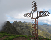
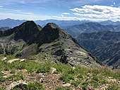
The Altemberg is located on the water divide between Strona and Sesia valleys, South of the Bocchetta Stretta pass[5], which divides it from the neighbouring Cima Lago. Towards SE the ridge goes on with a saddle named Bocchetta delle Vacche and the Cima del Pizzo (2,233 m)[6]. Administratively the mountain belongs to both the comunes of Rimella (West of the summit) and Valstrona.[7] On its summit stands a metallic cross[8].
SOIUSA classification
According to the SOIUSA (International Standardized Mountain Subdivision of the Alps) the mountain can be classified in the following way:[9]
- main part = Western Alps
- major sector = North Western Alps
- section = Pennine Alps
- subsection = Southern Valsesia Alps
- supergroup = Alpi Cusiane
- group = Costiera Capio-Massa del Turlo
- code = I/B-9.IV-B.3
Access to the summit
The Altemberg can be accessed following a foothpath from Campello Monti, a village in the comune of Valstrona, or from Rimella, in Valsesia[10]. The ridge between connecting the Altemberg with Cima Lago needs some climbing skill to be crossed and is rated as PD grade [4]
Nature conservation
Cima Altemberg is part of the regional park of Alta Val Sesia e dell'Alta Val Strona[11].
References
![]()
- "Walser" (in Italian). Comitato unitario delle isole linguistiche storiche germaniche in Italia. Retrieved 2019-04-08.
- "English translation of 'Alt'". Collins. Retrieved 2019-04-08.
- "English translation of 'Berg'". Collins. Retrieved 2019-04-08.
- Castello, Alessandro; Protto, Elio; Zoia, Sandro (2013). "Costiera Val Mastallone - Valle Strona". Alpi biellesi e valsesiane. Guida dei monti d'Italia (in Italian). CAI / Touring. p. 292.
- Also named Tesslu, see Boffa, Felice (1960). Monte Rosa: 98 schizzi, 40 fotoincisioni (in Italian). Club Alpino Italiano. p. 573.
- user titty79. "Capezzone (Cima) da Campello Monti, anello per Cima Lago, Altemberg e Pizzo" (in Italian). Retrieved 2019-04-08.
- Carta Tecnica Regionale raster 1:10.000 (vers.3.0), Regione Piemonte, year 2007
- Ceragioli, Filippo; Molino, Aldo (2018). "Alla testata della valle Strona". Escursioni imperdibili nei parchi del Piemonte e dintorni (in Italian). Edizioni del Capricorno. pp. 32–36.
- Marazzi, Sergio (2005). Atlante Orografico delle Alpi. SOIUSA (in Italian). Priuli & Verlucca. p. 134. ISBN 978-88-8068-273-8.
- "Rimella - Altemberg per la Bocchetta delle Vacche (Kihefurku)" (in Italian). CAI - Sezione di Varallo. Retrieved 2019-04-10.
- "Val Strona" (in Italian). Retrieved 2019-04-10.