Alne, North Yorkshire
Alne is a village and civil parish in the Hambleton District of North Yorkshire, England, about twelve miles north-west of York and four miles from Easingwold. The parish has a population of 711 (2001 census),[2] increasing to 756 at the 2011 census.[1]
| Alne | |
|---|---|
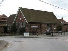 The village hall | |
 Alne Location within North Yorkshire | |
| Population | 756 (2011 census)[1] |
| OS grid reference | SE495654 |
| District | |
| Shire county | |
| Region | |
| Country | England |
| Sovereign state | United Kingdom |
| Post town | Easingwold |
| Postcode district | YO61 |
| Police | North Yorkshire |
| Fire | North Yorkshire |
| Ambulance | Yorkshire |
| UK Parliament | |
Etymology
The village is named in the Domesday Book as part of the Bulford Hundred and owned by the church of St Peter, York.[3] The name may be derived from the Latin word Alnus for Alder, as the village was surrounded by these trees.[4] The name could also be derived from a river-name of the Alaunā type, derived from Brittonic al-, "bright, shining" (Welsh alaw, "waterlily").[5] This may have been an alternative name for the River Kyle.[5]
History
The Parish used to include the nearby settlements of Tholthorpe, Aldwark, Flawith, Youlton and Tollerton, covering nearly 10,000 acres. To the north-east of the village used to be Alne Station opened in 1841, but was closed to passengers in 1958.[6] Alne Hall in the Middle Ages was the country residence of the treasurers of St Peter's, York.[7]
Governance
The village is within the Thirsk & Malton parliamentary constituency. It is within the Tollerton ward of Hambleton Local Government District and the Easingwold electoral district of North Yorkshire County Council. The civil parish is made up of four councillors.[8]
Geography
The village lies 2 miles (3.2 km) west of the A19 road and immediately north of the River Kyle. The village used to have a railway station on the East Coast Main Line that runs less than a mile to the east of the village.[9]
The soil contains some alluvium as well as sand and loam.[10] The land to the east of the village is a good source of brick clay, and supports the York Handmade Brick Company who have supplied specialist bricks to The Shard and London Bridge railway station.[11][12]
Village amenities
In the village there is Alne Cricket Club who play in the Nidderdale and District Amateur Cricket League.[13] The local Tennis Club play in local leagues at the local Recreational Playing Fields. There is also a public house, the Blue Bell Inn, which was one of three inns in the village in the 1820s.[14] The village is home to two Nursing and Care homes, Oak Trees and Leonard Cheshire.
The village also hosts an annual street fayre, which has been mentioned in The Times top 20 days out, that raises funds for the maintenance and improvement of the Alne recreation and sports park.[15]
Demography
The 2001 census showed that the population of the parish was 711 in 249 households. Of those dwellings, 159 are detached and 215 owner occupied. Of the total population, 497 are aged 16 or over of which 316 were in employment.[2]
In the 2011 census, the population was 756 in 272 dwellings.[1]
Education
The village has one school, Alne County Primary School, for pupils aged 4 to 11. Pupils receive their secondary education at Easingwold School.[16]
Religion
There is one church in the village, St Mary's, which is a Grade I listed building that has been extensively rebuilt from its original Norman structure.[17] There used to be a Methodist Chapel as well built in 1848.[10]
References
- UK Census (2011). "Local Area Report – Alne Parish (1170216796)". Nomis. Office for National Statistics. Retrieved 3 March 2018.
- UK Census (2001). "Local Area Report – Alne Parish (1543510228)". Nomis. Office for National Statistics. Retrieved 7 January 2019.
- Alne in the Domesday Book. Retrieved 20 October 2012.
- Ekwall, Eilert (1960). The concise Oxford dictionary of English place-names (4 ed.). Oxford: Oxford University Press. p. 7. ISBN 0-19-869103-3.
- James, Alan. "A Guide to the Place-Name Evidence" (PDF). SPNS - The Brittonic Language in the Old North. Archived from the original (PDF) on 13 August 2017. Retrieved 25 November 2018.
- "Disused Stations: Alne Station". www.disused-stations.org.uk. Retrieved 16 October 2018.
- "History". Retrieved 20 October 2012.
- "Contact details - Alne Parish Council". democracy.hambleton.gov.uk. 16 October 2018. Retrieved 16 October 2018.
- "Disused Stations: Alne Station". disused-stations.org.uk. Retrieved 16 November 2019.
- Bulmer's Topography, History and Directory (Private and Commercial) of North Yorkshire 1890. S&N Publishing. 1890. p. 640. ISBN 1-86150-299-0.
- "Brick firm to build on 10 successful years". infoweb.newsbank.com. 24 June 1998. Retrieved 16 November 2019.
- Casci, Mark (8 January 2018). "Profile: David Armitage, York Handmade Brick Company". The Yorkshire Post. Retrieved 16 November 2019.
- "Cricket club". Archived from the original on 7 July 2013. Retrieved 20 October 2012.
- Baines, Edward (1823). "History, directory & gazetteer of the county of York... (Vol. II - East and North Ridings)". Leeds: Edward Baines at the Leeds Mercury office. p. 405. Retrieved 9 October 2016.
- "Street fayre". Retrieved 20 October 2012.
- "Home - Alne Primary School". www.alne.n-yorks.sch.uk. Retrieved 22 January 2017.
- Historic England. "Church of St Mary (1151297)". National Heritage List for England. Retrieved 9 October 2016.
External links
