Algodor River
The Algodor is a 102 km long river in Central Spain. It is a left hand tributary to the Tagus.
| Algodor | |
|---|---|
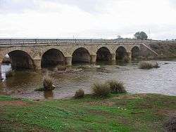 Bridge of the N-401 road over the Algodor near Los Yébenes. | |
 | |
| Location | |
| Country | Spain |
| Physical characteristics | |
| Source | |
| • location | Laguna del Navajo, Montes de Toledo |
| • elevation | 822 m (2,697 ft) |
| Mouth | |
• location | Tagus, near Algodor |
• elevation | 460 m (1,510 ft) |
| Length | 102 km (63 mi) |
| Basin size | 1,250 km2 (480 sq mi) |
| Discharge | |
| • average | 1.93 m3/s (68 cu ft/s) |
Course
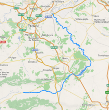
Its source is at the Laguna del Navajo in the Montes de Toledo, within the Retuerta del Bullaque municipal limits, Castile-La Mancha. It flows roughly northwards across the Province of Toledo into the Tagus at Aceca, a place near Algodor, the village within the Aranjuez municipality limits that gives the river its name.[1]
The Algodor River has two dams, which form the 133 hm³ Embalse de Finisterre reservoir built in 1977, located between Tembleque, Mora, Villanueva de Bogas and Turleque,[2] and the smaller 8 hm³ Embalse del Castro reservoir built in 1974 near Villamuelas.[3]
All the Algodor's tributaries are small rivulets except for the Bracea River on its left margin.