Alabama Hills
The Alabama Hills are a range of hills and rock formations near the eastern slope of the Sierra Nevada in the Owens Valley, west of Lone Pine in Inyo County, California.
| Alabama Hills | |
|---|---|
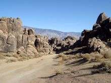
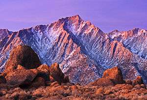 Rocks of the Alabama Hills with the Sierra Nevada in the background, winter dawn | |
| Highest point | |
| Elevation | 5,354 ft (1,632 m) [1] |
| Geography | |
 Location of Alabama Hills in California | |
| Country | United States |
| State | California |
| District | Inyo County |
| Range coordinates | 36°36′53″N 118°05′45″W [2] |
| Topo map | USGS Lone Pine, Union Wash |
Though geographically separate from the Sierra Nevada, they are part of the same geological formation.
Alabama Hills Recreation Area
The Alabama Hills are managed by the U.S. Bureau of Land Management (BLM) as the Alabama Hills Recreation Area. The area is managed as a protected habitat for public enjoyment.[3] In March 2019, the US congress redesignated the area as the Alabama Hills National Scenic Area as part of the John D. Dingell, Jr. Conservation, Management, and Recreation Act.[4]
Geology
The rounded contours of the Alabamas contrast with the sharp ridges of the Sierra Nevada to the west. Though this might suggest that they formed from a different orogeny, the Alabamas are the same age as the Sierra Nevada. The difference in wear can be accounted for by different patterns of erosion.
Mount Whitney, the tallest mountain in the contiguous United States, towers several thousand feet above this low range, which itself is 1,500 feet (460 m) above the floor of Owens Valley. However, gravity surveys indicate that the Owens Valley is filled with about 10,000 feet (3,000 m) of sediment and that the Alabamas are the tip of a very steep escarpment. This feature may have been created by many earthquakes similar to the 1872 Lone Pine earthquake which, in a single event, caused a vertical displacement of 15–20 feet.
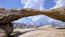
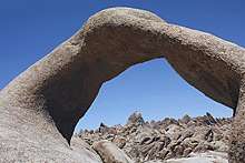
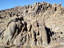
There are two main types of rock exposed at Alabama Hills. One is an orange, drab weathered metamorphosed volcanic rock that is 150–200 million years old. The other type of rock exposed here is 82- to 85-million-year-old biotite monzogranite which weathers to potato-shaped large boulders, many of which stand on end due to spheroidal weathering acting on many nearly vertical joints in the rock.
Dozens of natural arches are among the main attractions at the Alabama Hills. They can be accessed by short hikes from the Whitney Portal Road, the Movie Flat Road and the Horseshoe Meadows Road. Among the notable features of the area are: Mobius Arch, Lathe Arch, the Eye of Alabama and Whitney Portal Arch.
History
The Alabama Hills were named for the CSS Alabama, a Confederate warship deployed during the American Civil War. When news of the ship's exploits reached prospectors in California sympathetic to the Confederates, they named many mining claims after the ship, and the name came to be applied to the entire range.[5] When the Alabama was finally sunk off the coast of Normandy by the USS Kearsarge in 1864, prospectors sympathetic to the North named a mining district, a mountain pass, a mountain peak, and a town after the Kearsarge.[5]
Filming location
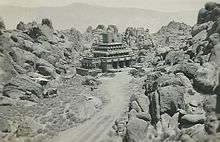
The Alabama Hills are a popular filming location for television and movie productions, especially Westerns set in an archetypical "rugged" environment. Since the early 1920s, 150 movies and about a dozen television shows have been filmed here, including Tom Mix films, Hopalong Cassidy films, The Gene Autry Show, The Lone Ranger and Bonanza. Meanwhile, Classics such as Gunga Din, The Walking Hills, Yellow Sky, Springfield Rifle, The Violent Men, Bad Day at Black Rock (1955), the Budd Boetticher/Randolph Scott "Ranown" westerns, part of How the West Was Won, and Joe Kidd. In the late 1940s and early 50s the area was also a popular location for the films of B-western actor Tim Holt.
More recent productions have been filmed at "movie ranch" sites known as Movie Flats and Movie Flat Road.
Astronomy
Alabama Hills features exceptional skies for Southern California. It is Bortle class 2 or "average dark sky" site; this low level of light pollution meets or exceeds conditions in many of other popular nearby areas for amateur astronomy, such as Joshua Tree National Park (Bortle class 2–4).[6] On a clear night with no moon, a visitor with good, dark adapted vision may see the Andromeda and Triangulum galaxies with the unaided eye; the central Milky Way appears highly structured under these conditions.[7]
References
- "Alabama Hills". ListsOfJohn.com. Retrieved 2012-11-16.
- "Alabama Hills". Geographic Names Information System. United States Geological Survey. Retrieved 2012-11-16.
- BLM Alabama Hills Recreation Area
- "Alabama Hills National Scenic Area". US Bureau of Land Management. Retrieved 2019-12-01.
- Kyle, Douglas E. and Hoover, Mildred Brooke (1990). Historic Spots in California, p. 122. Stanford, California: Stanford University Press. ISBN 0-8047-4483-1.
- "Light pollution map". www.lightpollutionmap.info. Retrieved 2018-07-13.
- "bortle dark sky scale". www.handprint.com. Retrieved 2018-07-13.
- Geology Underfoot in Death Valley and Owens Valley, Sharp, Glazner (Mountain Press Publishing Company, Missoula; 1997) ISBN 0-87842-362-1.
- Geologic map of the Lone Pine 15' quadrangle, Inyo County, California, scale 1:62,500, Stone, Paul, Dunne, G.C., Moore, J.G., and Smith, G.I., (U.S. Geological Survey Geologic Investigation Series I-26172000; 2000 ISBN 0-607-95258-X
External links
| Wikimedia Commons has media related to Alabama Hills. |
- Alabama Hills Recreation Area website (BLM)
- Films with shooting locations in the Alabama Hills (IMDb)
| Authority control |
|
|---|