Aeromagnetic survey
An aeromagnetic survey is a common type of geophysical survey carried out using a magnetometer aboard or towed behind an aircraft. The principle is similar to a magnetic survey carried out with a hand-held magnetometer, but allows much larger areas of the Earth's surface to be covered quickly for regional reconnaissance. The aircraft typically flies in a grid-like pattern with height and line spacing determining the resolution of the data (and cost of the survey per unit area).
Method
As the aircraft flies, the magnetometer measures and records the total intensity of the magnetic field at the sensor, which is a combination of the desired magnetic field generated in the Earth as well as tiny variations due to the temporal effects of the constantly varying solar wind and the magnetic field of the survey aircraft. By subtracting the solar, regional, and aircraft effects, the resulting aeromagnetic map shows the spatial distribution and relative abundance of magnetic minerals (most commonly the iron oxide mineral magnetite) in the upper levels of the Earth's crust. Because different rock types differ in their content of magnetic minerals, the magnetic map allows a visualization of the geological structure of the upper crust in the subsurface, particularly the spatial geometry of bodies of rock and the presence of faults and folds. This is particularly useful where bedrock is obscured by surface sand, soil or water. Aeromagnetic data was once presented as contour plots, but now is more commonly expressed as thematic (colored) and shaded computer generated pseudo-topography images. The apparent hills, ridges and valleys are referred to as aeromagnetic anomalies. A geophysicist can use mathematical modeling to infer the shape, depth and properties of the rock bodies responsible for the anomalies.
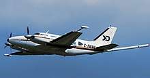
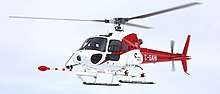
Airplanes are normally used for high-level reconnaissance surveys in gentle terrain, and helicopters are used in mountainous terrain or where more detail is required.
History
Aeromagnetic surveys were first performed in World War II to detect submarines using a Magnetic Anomaly Detector attached to an aircraft. This method is still widely used by military maritime patrol aircraft.
Uses
Aeromagnetic surveys are widely used to aid in the production of geological maps and are also commonly used during mineral exploration and petroleum exploration. Some mineral deposits are associated with an increase or decrease in the abundance of magnetic minerals, and occasionally the sought after commodity may itself be magnetic (e.g. iron ore deposits), but often the elucidation of the subsurface structure of the upper crust is the most valuable contribution of the aeromagnetic data. It has also been used to find buried fault zones that are prone to damaging earthquakes.[1]
Unexploded ordnance
Aeromagnetic surveys are also used to perform reconnaissance mapping of unexploded ordnance. The aircraft is typically a helicopter, as the sensors must be close to the ground (relative to mineral exploration) to be effective. Electromagnetic methods are also used for this purpose.
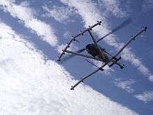
UAV aeromagnetic survey
Not so long ago in an aeromagnetic survey became using drones. Market of unmanned aerial systems is exponential develop. So the arrival of these technologies in some niches was inevitable including geophysical survey. Especially UAVs have proven its in mineral exploration and detection and identification Unexploded Ordnance objects using drone-mounted magnetometer.
Very interesting and useful research (2018-2019) was conducted by the Binghamton University and aviation production company UMT. Namely, they were success integrate UAV-based aeromagnetic survey system integrating the UMT Cicada hybrid-powered UAV platform and the Geometrics MFAM Microfabricated Atomic Magnetometer system. This approach with unmanned aerial vehicles application should make missions faster, cheaper and safer.
See also
- Geophysics
- Exploration geophysics
- Remote sensing
- Mineral exploration
References
- Kolawole, F.; Atekwana, E. A.; Malloy, S.; Stamps, D. S.; Grandin, R.; Abdelsalam, M. G.; Leseane, K.; Shemang, E. M. (2017-09-09). "Aeromagnetic, gravity, and Differential Interferometric Synthetic Aperture Radar analyses reveal the causative fault of the 3 April 2017 Mw6.5 Moiyabana, Botswana, earthquake". Geophysical Research Letters. 44 (17): 8837–8846. doi:10.1002/2017gl074620. ISSN 0094-8276.
- Burger RH, Sheehan AF, Jones CH (2006) Introduction to Applied Geophysics. Published by W. W. Norton, 600 p., ISBN 0-393-92637-0 / ISBN 978-0-393-92637-8.