Abisko
Abisko (Swedish: [ˈɑ̌ːbɪskʊ];[2] Northern Sami: Ábeskovvu) is a village in Sápmi (Lapland), in northern Sweden, roughly 250 km within the Arctic Circle, and near Abisko National Park, located 4 km west of the village. It had 85 inhabitants as of 2005.
Abisko | |
|---|---|
Village | |
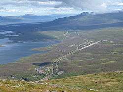 Picture of Abisko, taken from the mountain Nuolja. In the foreground, Abisko Turiststation and the bottom part of the Abisko canyon can be seen. Further away is the village Abisko Östra. To the left in the picture, the lake Torneträsk can be seen. | |
 Abisko  Abisko | |
| Coordinates: 68°21′N 18°49′E | |
| Country | Sweden |
| Municipality | Kiruna Municipality |
| County | Norrbotten County |
| Province | Lappland |
| Area | |
| • Total | 0.13 km2 (0.05 sq mi) |
| Population (2005-12-31)[1] | |
| • Total | 85 |
| • Density | 658/km2 (1,700/sq mi) |
| Time zone | UTC+1 (CET) |
| • Summer (DST) | UTC+2 (CEST) |
Permafrost is common around the village albeit this low altitude permafrost is disappearing because of global warming and increased snowfall.[3]
Transportation
Daily passenger electric trains run by SJ AB connect Stockholm with the Norwegian city of Narvik, stopping at both the Abisko village (the name of that railway station is Abisko Östra [east]) and the Abisko Turiststation. Additional regional trains provide links along the Kiruna-Narvik stretch. Abisko is also reachable by car via the highway E10 which has linked Kiruna and Narvik since the early 1980s. Other local forms of transportation include hiking and dog-sledding in winter. A chair-lift provides access to a point below the summit of nearby Mt. Nuolja.
Tourism
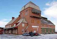
The 425 kilometer-long Kungsleden hiking trail, which follows the Scandinavian mountain range, starts (or ends) at the Abisko Turiststation (consisting of a railway station of the same name and the Abisko Youth Hostel) (approx. 4 km west of the village itself) and follows through the national park. The Nordkalottruta uses trails of the park as part of its longer passage. The Abisko Turiststation, run by the Svenska Turistföreningen (STF), houses many visitors to the park and provides lodging, food, and other amenities, and is one of many similar facilities located periodically along the Kungsleden trail. The national park is known for its Cross-country skiing opportunities, snowshoeing, and other winter sports (Mount Nuolja and nearby Björkliden provides Backcountry skiing and freeriding opportunities). As its location is 195 km north of the Arctic Circle, summer hikers enjoy the midnight sun, while winter visitors may find the light pollution-free location ideal for viewing the aurora borealis. One of the most recognized natural sights is Lapporten, a U-shaped valley visible from Abisko. Abisko is also located near the 330 square kilometre (130 sq mi) lake Torneträsk.
Research Station
Abisko is home to the Abisko Scientific Research Station, an important centre for research into Arctic ecology and climate change. The research station hosts the Climate Impacts Research Centre, Umeå University, where research, education and outreach on aquatic and terrestrial ecology are undertaken.
Climate
| Climate data for Abisko 1991–2018 (Sunshine 2002–2018) | |||||||||||||
|---|---|---|---|---|---|---|---|---|---|---|---|---|---|
| Month | Jan | Feb | Mar | Apr | May | Jun | Jul | Aug | Sep | Oct | Nov | Dec | Year |
| Record high °C (°F) | 8.3 (46.9) |
8.8 (47.8) |
9.9 (49.8) |
13.3 (55.9) |
25.9 (78.6) |
26.5 (79.7) |
32.8 (91.0) |
29.1 (84.4) |
21.9 (71.4) |
15.3 (59.5) |
10.6 (51.1) |
8.1 (46.6) |
32.8 (91.0) |
| Average high °C (°F) | −5.6 (21.9) |
−6.2 (20.8) |
−2.6 (27.3) |
2.5 (36.5) |
8.0 (46.4) |
13.4 (56.1) |
17.0 (62.6) |
14.9 (58.8) |
9.9 (49.8) |
3.4 (38.1) |
−1.1 (30.0) |
−3.4 (25.9) |
4.2 (39.5) |
| Daily mean °C (°F) | −9.8 (14.4) |
−10.3 (13.5) |
−6.6 (20.1) |
−1.3 (29.7) |
4.1 (39.4) |
9.1 (48.4) |
12.6 (54.7) |
10.9 (51.6) |
6.5 (43.7) |
0.6 (33.1) |
−4.4 (24.1) |
−7.0 (19.4) |
0.4 (32.7) |
| Average low °C (°F) | −13.4 (7.9) |
−14.5 (5.9) |
−10.7 (12.7) |
−5.2 (22.6) |
0.3 (32.5) |
4.9 (40.8) |
8.2 (46.8) |
6.9 (44.4) |
3.1 (37.6) |
−2.3 (27.9) |
−7.6 (18.3) |
−10.7 (12.7) |
−3.4 (25.8) |
| Record low °C (°F) | −35.5 (−31.9) |
−34.2 (−29.6) |
−33.1 (−27.6) |
−19.8 (−3.6) |
−11.4 (11.5) |
−1.8 (28.8) |
0.1 (32.2) |
−1.5 (29.3) |
−7.1 (19.2) |
−17.6 (0.3) |
−23.2 (−9.8) |
−30.2 (−22.4) |
−35.5 (−31.9) |
| Average precipitation mm (inches) | 27 (1.1) |
21 (0.8) |
19 (0.7) |
12 (0.5) |
19 (0.7) |
35 (1.4) |
63 (2.5) |
44 (1.7) |
31 (1.2) |
25 (1.0) |
21 (0.8) |
28 (1.1) |
344 (13.5) |
| Mean monthly sunshine hours | 0.0 | 40.2 | 128.2 | 175.8 | 230.2 | 228.0 | 237.1 | 175.3 | 97.5 | 69.2 | 2.2 | 0.0 | 1,383.7 |
| Source 1: SMHI Open Data | |||||||||||||
| Source 2: SMHI Monthly Data | |||||||||||||
| Climate data for Abisko (2002–2018; including extremes) | |||||||||||||
|---|---|---|---|---|---|---|---|---|---|---|---|---|---|
| Month | Jan | Feb | Mar | Apr | May | Jun | Jul | Aug | Sep | Oct | Nov | Dec | Year |
| Record high °C (°F) | 8.3 (46.9) |
8.8 (47.8) |
8.9 (48.0) |
13.3 (55.9) |
25.9 (78.6) |
26.5 (79.7) |
32.8 (91.0) |
28.7 (83.7) |
20.0 (68.0) |
15.3 (59.5) |
10.6 (51.1) |
7.7 (45.9) |
32.8 (91.0) |
| Mean maximum °C (°F) | 3.9 (39.0) |
4.5 (40.1) |
5.3 (41.5) |
9.6 (49.3) |
18.1 (64.6) |
21.7 (71.1) |
24.8 (76.6) |
23.3 (73.9) |
16.5 (61.7) |
10.4 (50.7) |
6.6 (43.9) |
5.1 (41.2) |
26.0 (78.8) |
| Average high °C (°F) | −6.6 (20.1) |
−6.1 (21.0) |
−2.4 (27.7) |
3.2 (37.8) |
8.8 (47.8) |
13.3 (55.9) |
17.5 (63.5) |
15.3 (59.5) |
10.2 (50.4) |
3.6 (38.5) |
−0.7 (30.7) |
−3.2 (26.2) |
4.4 (39.9) |
| Daily mean °C (°F) | −10.8 (12.6) |
−10.2 (13.6) |
−6.5 (20.3) |
−0.7 (30.7) |
4.8 (40.6) |
9.1 (48.4) |
13.0 (55.4) |
11.2 (52.2) |
6.8 (44.2) |
0.7 (33.3) |
−4.0 (24.8) |
−6.9 (19.6) |
0.5 (33.0) |
| Average low °C (°F) | −15.0 (5.0) |
−14.3 (6.3) |
−10.5 (13.1) |
−4.6 (23.7) |
0.7 (33.3) |
4.9 (40.8) |
8.5 (47.3) |
7.1 (44.8) |
3.3 (37.9) |
−2.3 (27.9) |
−7.2 (19.0) |
−10.5 (13.1) |
−3.3 (26.0) |
| Mean minimum °C (°F) | −26.5 (−15.7) |
−26.8 (−16.2) |
−22.7 (−8.9) |
−13.8 (7.2) |
−4.7 (23.5) |
−0.2 (31.6) |
3.1 (37.6) |
0.8 (33.4) |
−2.4 (27.7) |
−11.1 (12.0) |
−16.3 (2.7) |
−21.8 (−7.2) |
−30.0 (−22.0) |
| Record low °C (°F) | −34.7 (−30.5) |
−33.9 (−29.0) |
−33.1 (−27.6) |
−18.5 (−1.3) |
−8.0 (17.6) |
−1.8 (28.8) |
0.7 (33.3) |
−1.5 (29.3) |
−6.0 (21.2) |
−17.6 (0.3) |
−23.1 (−9.6) |
−30.2 (−22.4) |
−34.7 (−30.5) |
| Average precipitation mm (inches) | 24.4 (0.96) |
20.1 (0.79) |
18.6 (0.73) |
12.0 (0.47) |
19.6 (0.77) |
34.4 (1.35) |
67.5 (2.66) |
43.2 (1.70) |
38.9 (1.53) |
20.4 (0.80) |
17.6 (0.69) |
27.1 (1.07) |
343.8 (13.52) |
| Mean monthly sunshine hours | 0.0 | 40.2 | 128.2 | 175.8 | 230.2 | 228.0 | 237.1 | 175.3 | 97.5 | 69.2 | 2.2 | 0.0 | 1,383.7 |
| Source 1: SMHI Open Data[4] | |||||||||||||
| Source 2: SMHI climate data 2002–2018[5] | |||||||||||||
References
- "Småorternas landareal, folkmängd och invånare per km2 2000 och 2005" (xls) (in Swedish). Statistics Sweden. Retrieved 2009-02-27.
- Jöran Sahlgren; Gösta Bergman (1979). Svenska ortnamn med uttalsuppgifter (in Swedish). p. 4.
- Johansson, Margareta; Christensen, Torben R.; Akerman, H. Jonas; Callaghan, Terry V. (2006). "What Determines the Current Presence or Absence of Permafrost in the Torneträsk Region, a Sub-arctic Landscape in Northern Sweden?". AMBIO: A Journal of the Human Environment. 35 (4): 190–197. doi:10.1579/0044-7447(2006)35[190:WDTCPO]2.0.CO;2.
- "Öppen Data för Abisko" (in Swedish). Swedish Meteorological and Hydrological Institute.
- "SMHI climate data 2002–2018" (in Swedish). SMHI. 20 June 2019.