ABC Highway
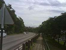
The ABC Highway is the main urban highway in Barbados. Opened in 1989, it is named after three famous Barbadian politicians: John Michael Geoffrey Manningham ("Tom") Adams, Errol Barrow, and Hugh Gordon Cummins. From the east, the highway stretches from the Grantley Adams International Airport in Christ Church, to the western end at Cave Hill Road and University Drive, Cave Hill Campus, University of the West Indies, in Saint Michael. It roughly encircles the Parish of Saint Michael and wider metropolitan area of Bridgetown.
| ABC Highway | |
|---|---|
| Major junctions | |
| From | Grantley Adams International Airport in Christ Church |
| To | Cave Hill Campus, University of the West Indies, in Saint Michael |
| Highway system | |
| Barbados Highways | |

The highway consists of both two-lane and dual carriageway sections with at-grade intersections, mostly roundabouts. A 2006–2007 expansion project enlarged some sections and there was some public sentiment voiced in local media about the project's lack of a competitive tender process or studies to justify costs. The construction and widening of the ABC Highway from the Darcy Scott Roundabout in Warrens, St. Michael to the Garfield Sobers Roundabout in Bartletts, Christ Church was started on 24 July 2006 with two local construction companies, Rayside Construction and C.O. Williams Construction when they removed the old streetlights and the old traffic lights at the junctions of the ABC Highway and Pine East-West Boulevard, Upton Road at BET Hill on Highway R and Highway 6; constructed jersey barriers in the centre with the installation of the new HPS streetlights on the highway; constructed the new roundabouts like the Samuel Jackman Prescod and Darcy Scott Roundabouts in Warrens and the Pine, St. Michael. The Greater Warrens Traffic Improvement Project was started from late December 2010 into early January 2011 to mid-December 2014 with a construction and widening of Jackson Road on Highway 2 to the newly constructed Jackson Roundabout around the Baobab Tree and Lodge Hill, St. Michael, two Warrens Mini Roundabouts in Warrens, St. Michael and the Welches and Redmans Village Roundabouts in St. Thomas. On 27 April 2008, during its effect, they changed the junctions from a two-way street into a one-way street with the Wildey "Y" Junction of Upton Road on Highway R, the ABC Highway and Highway 6, and there was also a construction of a footbridge at the Pine, St. Michael from early September to late November 2012. They had also installed two new traffic lights; one at the pedestrian crossing at Mount Friendship, St. Michael, and another at Redman's Village, St. Thomas. The construction of the four-lane highway has been finished by 31 August 2009. Also, the same construction with the Greater Warrens Traffic Improvement Project had started with the widening of the Ronald Mapp Highway on Highway 2A from the top of Warrens Hill, St. Michael to the top of Redman's Village, St. Thomas with the installation of jersey barriers and new streetlights along Highway 2A, Jackson Road on Highway 2 and the Warrens South Road with three roundabouts: two mini and a circular roundabout. Highway 2A between the top of Warrens Hill in St. Michael to the top of Redman's Village in St. Thomas via Welches in St. Thomas, was unfinished and incomplete and will soon be finished and completed after the elections of the new BLP Government. Finally in the parish of St. Michael, from late April 2001 to late October 2003, they constructed from its entrance and exit to Dalkeith Road at the Garrison Savannah along with the junctions of Dalkeith Road and Harts Road; Dalkeith Road, Dalkeith Hill, Beckles Road and Culloden Road; Culloden Road, Pine Road, Bishop's Court Hill and Collymore Rock; Pine Road, with a reconstruction of Nita Barrow Roundabout, Pine Hill, Welches Road and Belmont Road, Government Hill, Welches Main Road and Tweedside Road; the junction of Roebuck Street and Country Road; the junction of Country Road, Passage Road, Whitepark Road and Bank Hall Road; the junction of Passage Road, Westbury Road, Baxters Road and Barbarees Hill; the junction of Westbury Road, Westbury Main Road, Prescod Boulevard and President Kennedy Drive; the junction of Eagle Hall Main Road, Black Rock Road, Barbarees Hill and Tudor Bridge; the junction of Black Rock Road, Black Rock Main Road, Deacons Road and Fairfield Road, some of the traffic lights and streetlights; and the junction of Black Rock Main Road, Brighton Road and Yearwood Road; and also they constructed Baxters Road before they removed all of the old utility poles and replaced them with some of the CFL English lampposts.
Junctions
| Parish | Location | km | mi | Destinations | Notes |
|---|---|---|---|---|---|
| Christ Church | Seawell | 0.0 | 0.0 | Highway 7 (Tom Adams Roundabout) | 13°4′49″N 59°29′28″W |
| Newton Terrace | 4.4 | 2.7 | Highway T (Henry Forde Roundabout) | 13°4′49″N 59°31′50″W | |
| Kendal Hill | 7.5 | 4.7 | Kendal Hill Road (Edwy Talma Roundabout) | 13°4′42″N 59°33′28″W | |
| Graeme Hall | 8.7 | 5.4 | Graeme Hall Road (Errol Barrow Roundabout) | 13°4′38″N 59°34′6″W | |
| Saint Michael | Wildey | 10.3 | 6.4 | Highway 6 (Sir Garfield Sobers Roundabout) | 13°5′13″N 59°34′37″W |
| 10.8– 11.6 | 6.7– 7.2 | Highway 6 / Highway R (Wildey Triangle[1]) | No access to Highway R from westbound lanes, 13°5′26″N 59°34′50″W | ||
| 12.0 | 7.5 | Samuel Jackman Prescod Polytechnic Roundabout | 13°5′43″N 59°34′48″W | ||
| Haggatt Hall | 13.1 | 8.1 | Highway 5 (J.T.C. Ramsey Roundabout) | 13°6′18″N 59°34′48″W | |
| Rouen | Highway 4 (Norman A. Niles Roundabout) | 13°6′49″N 59°35′0″W | |||
| Friendship/Belle | Highway 3 (Clyde Walcott Roundabout) | 13°7′36″N 59°35′43″W | |||
| Warrens | Highway 2 (Everton Weekes Roundabout) | 13°8′30″N 59°36′23″W | |||
| Ronald Mapp Highway (D'Arcy Scott Roundabout) | 13°8′34″N 59°36′36″W | ||||
| Cave Hill, Saint Michael | University Drive, Cave Hill Road | Road continues as University Drive to the Frank Worrel Roundabout. 13°7′54″N 59°38′0″W | |||
| 1.000 mi = 1.609 km; 1.000 km = 0.621 mi | |||||
Route to port
The ABC Highway provides relative ease of access to the Deep Water Harbour in Bridgetown. At the official western terminus, the road becomes University Drive (at Cave Hill). The road proceeds to the Frank Worrel roundabout where it has a junction with Highway 1 and the MacDonald 'Mighty Grynner' Blennman (formerly "Spring Garden") Highway. From the Frank Worrel roundabout, direct access to the harbour is available via the M.G. Highway. At the end of M.G. Highway, direct access to the port is accessed by turning right onto President Kennedy Drive.
See also
References
- "Barbados Government Experiments With Traffic Changes At Wildey, St. Michael | Barbados Underground". Bajan.wordpress.com. Retrieved 2015-12-17.
External links
| Wikimedia Commons has media related to ABC Highway. |
- "Totally Barbados". Retrieved December 5, 2007.
- "Caribbean PressReleases.com". Retrieved December 5, 2007.
- "Barbados Underground". Retrieved December 5, 2007.