1953 Sarnia tornado outbreak
The 1953 Sarnia tornado outbreak was a localized, but devastating series of three intense tornadoes that affected the Iowa, Michigan, and Ontario. Eight people were killed and at least 75 others were injured.[1]
Part of the tornado outbreaks of 1953 | |
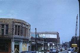 Aftermath: the photo here was taken by Gordon Cooke, a chemical engineer at Imperial Oil a couple of days later as the cleanup began. | |
| Type | Tornado outbreak |
|---|---|
| Duration | May 20–21, 1953 |
| Tornadoes confirmed | 3 |
| Max. rating1 | F4 tornado |
| Duration of tornado outbreak2 | 2 days |
| Casualties | 8 fatalities, At least 75 injuries |
| Areas affected | Iowa, Michigan, Ontario |
| 1Most severe tornado damage; see Fujita scale 2Time from first tornado to last tornado | |
Confirmed tornadoes
| FU | F0 | F1 | F2 | F3 | F4 | F5 | Total |
|---|---|---|---|---|---|---|---|
| 0 | 0 | 0 | 0 | 2 | 1 | 0 | 3 |
May 20 event
| F# | Location | County / Parish | State | Start Coord. | Time (UTC) | Path length | Max width | Summary | Refs |
|---|---|---|---|---|---|---|---|---|---|
| F3 | NE of Zenorsville to SW of Lime Springs | Story, Hardin, Butler Chicasaw, Howard | IA | 42.15°N 93.7°W | 0300 | 116.1 mi (186.8 km) | 400 yd (370 m) | 1 death – A long-tracked, strong tornado caused major damage while passing through the rural communities of Story City, Hubbard, Ackley, and Southern Alta Vista. | [2] |
| F3 | Eastern Cedar Rapids to NNW of Wyoming | Linn, Jones | IA | 41.98°N 91.57°W | 0410 | 38.6 mi (62.1 km) | 400 yd (370 m) | A strong tornado touched down on the eastern side of Cedar Rapids and tracked east-northeastward, hitting the town of Martelle. The town sustained major damage as multiple homes and businesses were heavily damaged or destroyed. The tornado dissipated halfway between Onslow and Wyoming. Seven people were injured. | [3] |
May 21 event
| F# | Location | County / Parish | State | Start Coord. | Time (UTC) | Path length | Max width | Summary | Refs |
|---|---|---|---|---|---|---|---|---|---|
| F4 | N of Smiths Creek, MI to Port Huron to Sarnia, ON to S of Stratford | St. Clair (MI), Lambton (ON), Middlesex | MI | 41.73°N 98.93°W | 2121 | ≥85 mi (137 km) | ≥1,760 yd (1,610 m) | 7 deaths – See section on this tornado – At least 68 people were injured. | [4][5] |
Port Huron, Michigan–Sarnia, Ontario
| F4 tornado | |
|---|---|
| Max. rating1 | F4 tornado |
| Casualties | 7 fatalities, ≥68 injuries |
| 1Most severe tornado damage; see Fujita scale | |
This large, violent tornado touched down just before 4:30 p.m. near Smiths Creek, Michigan, southwest of Port Huron. It moved northeast and quickly strengthened before hitting Port Huron, resulting in widespread F3 and F4 damage. Two people were killed in Port Huron and 68 more were injured. Close to 400 homes were damaged or destroyed in the United States with monetary losses totaling $2.6 million ($24.4 million 2018 USD)(Grazulis, 1990). Crossing the St. Clair River into Canada, the 1 mi (1.6 km) wide tornado moved into Canada just south of Sarnia Harbour (Grazulis, 1990).[6] Moving to the northeast, the tornado moved through directly through Downtown Sarnia, Ontario, where almost 100 commercial buildings sustained damage.[5] At least 150 homes on the more suburban outskirts of the city were damaged and in some instances reduced to rubble. Before exiting Sarnia, the tornado curved even further to the northeast and began to weaken, as its path narrowed to approximately 30 m (33 yd) across.[5] The tornado then restrengthened as it moved into rural Lambton and Middlesex Counties, with more F4 damage was inflicted upon farmsteads and homes near Nairn, before it dissipated south of Stratford (Grazulis, 1990). This suggested a total path length exceeding 120 km (75 mi), though it is highly probable that this damage path was made up of more than one tornado, possibly as many as four.[7] Overall, the tornado killed seven people and injured at least 68.[4][5]
Notes
- All dates are based on the local time zone where the tornado touched down; however, all times are in Coordinated Universal Time for consistency.
References
- "Tornado History Project: 1953". www.tornadohistoryproject.com.
- "Tornado History Project: 19530520.19.11". www.tornadohistoryproject.com.
- "Tornado History Project: 19530428.40.20". www.tornadohistoryproject.com.
- "Tornado History Project: 19530521.26.2". www.tornadohistoryproject.com.
- "Archived copy" (PDF). Archived from the original (PDF) on April 2, 2012. Retrieved June 15, 2011.CS1 maint: archived copy as title (link)
- "Our History – Bluewater Power Distribution". Archived from the original on September 10, 2011. Retrieved June 17, 2011.
- Tornadoes - Atmospheric Hazards Web Site - Ontario - Adaptation and Impacts Research Group - [Meteorological Service of Canada - The Green Lane]
Sources
- Grazulis, T. (1990). Significant Tornadoes: 1880–1989, Vol. 2. St. Johnsbury, Vermont: Environmental Films.