Ōyasuba Kofun
Ōyasuba Kofun (大安場古墳群, Ōyasuba Kofun gun) is an Archaeological park containing a group of middle Kofun period kofun burial tumuli located in what is now part of the city of Kōriyama, Fukushima in the southern Tohoku region of Japan. The site consists of one keyhole-shaped kofun and four dome-shaped kofun. The keyhole-shaped kofun is the largest in the Tohoku region. The site was designated a National Historic Site of Japan in 2000.[1]
大塚山古墳 | |
 | |
Ōyasuba Kofun  Ōyasuba Kofun (Japan) | |
| Location | Kōriyama, Fukushima, Japan |
|---|---|
| Region | Tohoku region |
| Coordinates | 37°21′23″N 140°24′12″E |
| Type | Kofun |
| History | |
| Founded | Kofun period |
| Site notes | |
| Ownership | National Historic Site |
| Public access | Yes |
Overview
The site is located on the east side of the Abukuma River, which flows through from the south to the north, at an altitude of about 250 meters. Discovered in 1991, the Koriyama City Board of Education conducted an excavation study from 1996 to 1998.
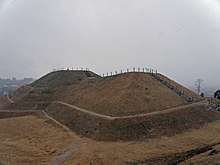
The keyhole-shaped kofun has a length of 83 meters and is orientated in a north-south direction. It was constructed by partly cutting out the natural hill next to the tumulus. A large amount of pot-shaped Sue ware with a hole in the bottom was excavated from the slopes of the mound, and it was likely that these were originally kept on the mount top. The interior has a clay-floored burial chamber with a length of 10 meters and width of two meters, containing a 9.2 meter long tree-coffin. The tomb had a large quantity of grave goods, including swords, spears, sickles, fragments of armor as well as jewelry, which date the construction to around the second half of the 4th century
The remaining dome-shaped kofun were not well preserved, and are believed to be the tombs of the leaders of a nearby settlement.
References
- "大安場古墳群" (in Japanese). Agency for Cultural Affairs.
External links
| Wikimedia Commons has media related to Oyasuba ancient tomb. |
- Oyasuba Park information home page (in Japanese)
- Kōriyama tourist information home page (in Japanese)