Ñuble Province
Ñuble Province (Spanish: Provincia de Ñuble, pronounced [ˈɲuβle]) was one of the provinces of the Chilean region of Bío Bío (VIII). It used to span an area of 13,178.5 km2 (5,088 sq mi) and it was administratively constituted by 21 communes. It has in 2017 a population of 441,604 inhabitants. Its capital was the city of Chillán. On the 6th of September of 2018, the province became the Ñuble Region.
Ñuble Province Provincia de Ñuble | |
|---|---|
 Seal | |
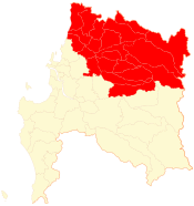 Location in the Bío Bío Region | |
| Coordinates: 36°37′00″S 71°57′00″W | |
| Country | Chile |
| Region | Bío Bío |
| Capital | Chillán |
| Communes | |
| Area | |
| • Total | 13,178.5 km2 (5,088.2 sq mi) |
| Population (2012 Census)[1] | |
| • Total | 460,113 |
| • Density | 35/km2 (90/sq mi) |
| • Urban | 285,108 |
| • Rural | 152,995 |
| Sex | |
| • Men | 217,024 |
| • Women | 221,079 |
| Time zone | UTC-4 (CLT[2]) |
| • Summer (DST) | UTC-3 (CLST[3]) |
| Area code(s) | 56 + 42 |
History
The Ñuble province was created in 1848 with the San Carlos Department of Maule Province and Chillán Department of Concepción Province. In 1884, the departments of Bulnes and Yungay, were created from the Chillán Department. In 1927, the provincial limits were modified and the Itata Department was added from Maule. Later, in 1976, the communes of Coelemu and Ránquil from Concepción Province, and the commune of Tucapel from Bío Bío Province, were added.
Following the 8.8 magnitude earthquake and tsunami, at least eight small communities and two towns were abandoned by residents, who took up makeshift camps in the hills, fearful of further tsunamis. Over 800 residences in the town of Quirihue were destroyed, leaving little for townspeople to return to.[4]
In 2015 the Ñuble Region law which converts the Ñuble Province into a Region, was proposed.[5] In August 2017 a law to create the new territorial division was promulgated by the President of the Republic in Chillán.[6][7] It became operational on 6 September 2018.[8]
Administration
As a province, Ñuble was a second-level administrative division of Chile, governed by a provincial governor who was appointed by the president.
Communes
The province used to comprise 21 communes, each governed by a municipality consisting of an elected alcalde and municipal council.
- Bulnes
- Cobquecura
- Coelemu
- Coihueco
- Chillán
- Chillán Viejo
- El Carmen
- Ninhue
- Ñiquén (San Gregorio de Ñiquén)
- Pemuco
- Pinto
- Portezuelo
- Quillón
- Quirihue
- Ránquil
- San Carlos
- San Fabián
- San Ignacio
- San Nicolás
- Treguaco
- Yungay
See also
References
- "Territorial division of Chile" (PDF) (in Spanish). National Statistics Institute. 2007. Retrieved 18 March 2011.
- "Chile Time". WorldTimeZones.org. Retrieved 2010-07-28.
- "Chile Summer Time". WorldTimeZones.org. Retrieved 2010-07-28.
- Mica Rosenberg (3 March 2010). "Fearing tsunamis in Chile, hundreds hide in hills". Reuters. Retrieved 4 March 2010.
- "Senado aprueba proyecto que crea la región de Ñuble".
- "Con firma de Bachelet hoy nace Región de Ñuble". latercera. Retrieved 21 August 2017.
- "Presidenta Bachelet firma decreto: Ñuble se convierte en la XVI región del país". biobiochile.cl. Retrieved 21 August 2017.
- "LEY-21033 05-SEP-2017 MINISTERIO DEL INTERIOR Y SEGURIDAD PÚBLICA - Ley Chile - Biblioteca del Congreso Nacional". 5 September 2017.
| Concepción |  | |
|---|---|---|
| Bío Bío | ||
| Arauco | ||
| Cachapoal |  | |
|---|---|---|
| Cardenal Caro | ||
| Colchagua | ||
Provincial capitals in italics • Regional capital in bold | ||