Île Haute
Île Haute is one of the Kerguelen Islands situated in the Golfe du Morbihan near the coast of Grande Terre, the principal island.
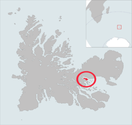 The île Haute is highlighted on this Kerguelen Islands map. | |
| Geography | |
|---|---|
| Location | Indian Ocean |
| Coordinates | 49°22′S 69°54′E |
| Archipelago | Îles Kerguelen |
| Length | 6 km (3.7 mi)[1] |
| Width | 2 km (1.2 mi)[1] |
| Highest elevation | 321 m (1,053 ft).[1] |
| Highest point | Table des Mouflons |
| Administration | |
| District | Îles Kerguelen |
| Demographics | |
| Population | 0 |
It is around 6 km long and 2 km wide. The highest point is the Table des Mouflons, at 321 metres.
References
- General view of non-metropolitan France, Maison de la Géographie.
- Kerguelen islands map, Géoportail IGN
This article is issued from Wikipedia. The text is licensed under Creative Commons - Attribution - Sharealike. Additional terms may apply for the media files.