Zwentendorf
| Zwentendorf an der Donau | ||
|---|---|---|
.JPG) Nuclear power station at Zwentendorf | ||
| ||
 Zwentendorf an der Donau Location within Austria | ||
| Coordinates: 48°20′33″N 15°54′50″E / 48.34250°N 15.91389°ECoordinates: 48°20′33″N 15°54′50″E / 48.34250°N 15.91389°E | ||
| Country | Austria | |
| State | Lower Austria | |
| District | Tulln | |
| Government | ||
| • Mayor | Hermann Kühtreiber (SPÖ) | |
| Area | ||
| • Total | 53.85 km2 (20.79 sq mi) | |
| Elevation | 182 m (597 ft) | |
| Population (1 January 2016)[1] | ||
| • Total | 4,012 | |
| • Density | 75/km2 (190/sq mi) | |
| Time zone | UTC+1 (CET) | |
| • Summer (DST) | UTC+2 (CEST) | |
| Postal code | 3435 | |
| Area code | 02277 | |
| Vehicle registration | TU | |
| Website | www.zwentendorf.at | |

Zwentendorf an der Donau is a small market municipality in the Austrian state of Lower Austria. It is located at 48°21′N 15°54′E / 48.350°N 15.900°E, in the Tulln Basin on the southern bank of the Danube. The place attained public attention as the site of the only Austrian nuclear power station, which was completed but never went into operation. In a referendum on 5 November 1978, a narrow majority of 50.5% voted against putting the Zwentendorf nuclear plant into operation.[2]
Population
| Historical population | ||
|---|---|---|
| Year | Pop. | ±% |
| 1869 | 2,562 | — |
| 1880 | 2,624 | +2.4% |
| 1890 | 2,585 | −1.5% |
| 1900 | 2,529 | −2.2% |
| 1910 | 2,782 | +10.0% |
| 1923 | 2,772 | −0.4% |
| 1934 | 2,945 | +6.2% |
| 1951 | 3,079 | +4.6% |
| 1961 | 3,123 | +1.4% |
| 1971 | 3,123 | +0.0% |
| 1981 | 3,170 | +1.5% |
| 1991 | 3,280 | +3.5% |
| 2001 | 3,715 | +13.3% |
| 2011 | 3,920 | +5.5% |
| 2014 | 4,001 | +2.1% |
History
Near Zwentendorf was from 1 to the 5th century a.d. a Roman fort (Asturis). It was a part from Limes Norici of the Roman province Noricum.
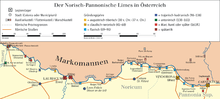
Limes Norici
See also
References
- ↑ Statistik Austria - Bevölkerung zu Jahresbeginn 2002-2016 nach Gemeinden (Gebietsstand 1.1.2016) for Zwentendorf an der Donau.
- ↑ Zwentendorf, a Nuclear Plant That Will Never Be Turned on Archived May 11, 2011, at the Wayback Machine.
External links
| Wikimedia Commons has media related to Zwentendorf an der Donau. |
This article is issued from
Wikipedia.
The text is licensed under Creative Commons - Attribution - Sharealike.
Additional terms may apply for the media files.