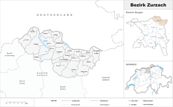
Zurzach District
| Zurzach District Bezirk Zurzach | |
|---|---|
| District | |
 | |
| Country |
|
| Canton |
|
| Capital | Bad Zurzach |
| Area | |
| • Total | 129.99 km2 (50.19 sq mi) |
| Population (2017) | |
| • Total | 34,073 |
| • Density | 260/km2 (680/sq mi) |
| Time zone | UTC+1 (CET) |
| • Summer (DST) | UTC+2 (CEST) |
| Municipalities | 22 |
Zurzach District is a district in the Swiss Canton of Aargau. The district capital is Bad Zurzach. It covers the Studenland area and is located in the northeastern part of the canton. It has a population of 34,073 (as of 31 December 2017).[1]
Geography
The Zurzach district has an area, as of 2009, of 129.99 square kilometers (50.19 sq mi). Of this area, 57.08 km2 (22.04 sq mi) or 43.9% is used for agricultural purposes, while 51.23 km2 (19.78 sq mi) or 39.4% is forested. Of the rest of the land, 16.62 km2 (6.42 sq mi) or 12.8% is settled (buildings or roads).[2] The district is situated around the confluence of the Aare and Rhine.
Demographics
The Zurzach district has a population (as of December 2017) of 34,073.[1] As of June 2009, 25.7% of the population are foreign nationals.[3]
Economy
In 2000 there were 15,454 workers who lived in the district. Of these, 11,295 or about 73.1% of the residents worked outside the district while 6,024 people commuted into the district for work. There were a total of 10,183 jobs (of at least 6 hours per week) in the district.[4]
Religion
From the 2000 census, 16,378 or 54.3% were Roman Catholic, while 7,440 or 24.7% belonged to the Swiss Reformed Church. Of the rest of the population, there were 65 individuals (or about 0.22% of the population) who belonged to the Christian Catholic faith.[2]
Education
Of the school age population (in the 2008/2009 school year), there are 2,405 students attending primary school, there are 972 students attending secondary school, there are 756 students attending tertiary or university level schooling in the municipality.[2]
Municipalities
| Coat of arms | Municipality | Population (31 December 2017)[1] |
Area, km²[5][6] |
|---|---|---|---|
| Baldingen | 261 | 2.83 | |
| Böbikon | 174 | 2.59 | |
| Böttstein | 3,986 | 7.41 | |
| Döttingen | 3,894 | 6.92 | |
| Endingen | 2,574 | 11.91. | |
| Fisibach | 478 | 5.79 | |
| Full-Reuenthal | 879 | 4.82 | |
| Kaiserstuhl | 423 | 0.32 | |
| Klingnau | 3,472 | 6.71 | |
| Koblenz | 1,673 | 4.08 | |
| Leibstadt | 1,289 | 6.39 | |
| Lengnau | 2,743 | 12.67 | |
| Leuggern | 2,148 | 13.76 | |
| Mellikon | 241 | 2.71 | |
| Rekingen | 968 | 3.1 | |
| Rietheim | 753 | 3.93 | |
| Rümikon | 312 | 2.9 | |
| Schneisingen | 1,391 | 8.25 | |
| Siglistorf | 630 | 5.51 | |
| Tegerfelden | 1,204 | 7.11 | |
| Wislikofen | 338 | 3.75 | |
| Total | 34,073 | 129.99 |
Mergers
The following changes to the district's municipalities have occurred since 2000:
- 1 January 2014: Unterendingen merged into Endingen[7]
References
- 1 2 3 Swiss Federal Statistical Office - STAT-TAB, online database – Ständige und nichtständige Wohnbevölkerung nach institutionellen Gliederungen, Geburtsort und Staatsangehörigkeit (in German) accessed 17 September 2018
- 1 2 3 Statistical Department of Canton Aargau - Aargauer Zahlen 2009 (in German) accessed 20 January 2010
- ↑ Statistical Department of Canton Aargau -Bereich 01 -Bevölkerung (in German) accessed 20 January 2010
- ↑ Statistical Department of Canton Aargau-Bereich 11 Verkehr und Nachrichtenwesen (in German) accessed 21 January 2010
- ↑ Swiss Federal Statistical Office-Land Use Statistics 2009 data (in German) accessed 25 March 2010
- ↑ Arealstatistik Standard - Gemeindedaten nach 4 Hauptbereichen
- ↑ Nomenklaturen – Amtliches Gemeindeverzeichnis der Schweiz (in German) accessed 13 December 2014
Coordinates: 47°35′N 8°17′E / 47.583°N 8.283°E