Ziro Province
For the town in India, see Ziro.
| Ziro | |
|---|---|
| Province | |
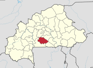 Location in Burkina Faso | |
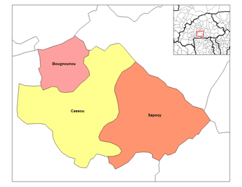 Provincial map of its departments | |
| Country |
|
| Region | Centre-Ouest Region |
| Capital | Sapouy |
| Area | |
| • Total | 5,139 km2 (1,984 sq mi) |
| Population (2011) | |
| • Total | 207,079 |
| • Density | 40/km2 (100/sq mi) |
| Time zone | UTC+0 (GMT 0) |
Ziro is a province of Burkina Faso, located in its Centre-Ouest Region. It has an area of 5,139 square kilometres (1,984 sq mi). The provincial capital is the town of Sapouy.
Education
In 2011 the province had 153 primary schools and 10 secondary schools.[1]
Healthcare
In 2011 the province had 17 health and social promotion centers (Centres de santé et de promotion sociale), 2 doctors and 47 nurses.[1]
Demographics
| 1985 | 1996 | 2006 | 2011 | |
|---|---|---|---|---|
| Ziro | 88,514 | 119,219 | 172,559[3] | 207,079 (est.) |
Administrative divisions
Prior to 2004 Ziro was divided into three departments: Bougnounou, Cassou and Sapouy.[4] After the 2004 reorganization Ziro was divided into six departments,[5] listed with their administrative seat, and population as of 2006 census.[6]
| Department | Capital | Population (Census 2006)[7] |
|---|---|---|
| Bougnounou Department | Bougnounou | 21,202 |
| Cassou Department | Cassou | 40,038 |
| Sapouy Department | Sapouy | 55,968 |
| Gao Department | Gao | 19,884 |
| Dalo Department | Dalo | 10,746 |
| Bakata Department | Bakata | 28,077 |
See also
Notes
- 1 2 3 "La région du Centre-Ouest en chiffres" (PDF). Institut National de la Statistique et de la Démographie (INSD). 2011. p. 6.
- ↑ "La région du Centre-Ouest en chiffres" (PDF). Institut National de la Statistique et de la Démographie (INSD). 2007. p. 6. Archived (PDF) from the original on 13 November 2010.
- ↑ The 2007 INSD report said 156,286 for 2006; however the 2011 INSD report revised that figure to 172,559.
- ↑ "Manuel du Controleur: Enquête Burkinabé sur les Conditions de Vie des Ménages" (PDF). Institut National de la Statistique et de la Démographie (INSD). 2003. p. 18. Archived (PDF) from the original on 13 November 2010.
- ↑ "Province: Ziro". Institut National de la Statistique et de la Démographie (INSD). Archived from the original on 23 October 2012.
- ↑ Kabore, Mahamoudou & Ouedraogo, Flore Gabrielle (2009). "Recensement General de la Population et de l'Habitation de 2006 (RGPH-2006): Monographie de la Region du Centre Ouest" (PDF). Institut National de la Statistique et de la Démographie (INSD). p. 26. Archived (PDF) from the original on 13 November 2010.
- ↑ National 2006 census preliminary results
Coordinates: 11°35′N 1°55′W / 11.583°N 1.917°W
This article is issued from
Wikipedia.
The text is licensed under Creative Commons - Attribution - Sharealike.
Additional terms may apply for the media files.