Zell, Carinthia
| Zell Sele | ||
|---|---|---|
 | ||
| ||
 Zell Location within Austria | ||
| Coordinates: 46°28′N 14°23′E / 46.467°N 14.383°ECoordinates: 46°28′N 14°23′E / 46.467°N 14.383°E | ||
| Country | Austria | |
| State | Carinthia | |
| District | Klagenfurt-Land | |
| Government | ||
| • Mayor | Engelbert Wassner (SPÖ) | |
| Area | ||
| • Total | 75.3 km2 (29.1 sq mi) | |
| Elevation | 948 m (3,110 ft) | |
| Population (1 January 2016)[1] | ||
| • Total | 600 | |
| • Density | 8.0/km2 (21/sq mi) | |
| Time zone | UTC+1 (CET) | |
| • Summer (DST) | UTC+2 (CEST) | |
| Postal code | 9170 | |
| Area code | 04227 | |
| Website | www.zell-sele.at | |

Zell (Slovene: Sele) is a municipality in the district of Klagenfurt-Land in the Austrian state of Carinthia.
Geography
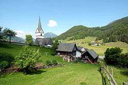
Zell lies in a side valley on the north of the Karawank on the Slovenian border about 20 km south of Klagenfurt and 6 km south of Ferlach.
Population
According to the 2001 census, 89.1% of the inhabitants are of Carinthian Slovenian descent, which is the highest percentage of all municipalities in the state of Carinthia.
The commune is situated southwest of the town of Ferlach, on the northern slope of the Koschuta Massif within the Karawanks mountain range. The place was first mentioned as Cel in a 1280 deed. It consists of six villages:
| Village (German) | Village (Slovenian) | Number of people 1991 | Percent of Slovenes 1991 | Percent of Slovenes 1951 |
|---|---|---|---|---|
| Zell Freibach | Sele Borovnica | 187 | 92.5% | 96.9% |
| Zell Homölisch | Sele Hmelše | 23 | 47.8% | 76.3% |
| Zell Mitterwinkel | Sele Srednji Kot | 98 | 98% | 95.7% |
| Zell Oberwinkel | Sele Zvrhnji Kot | 91 | 96.7% | 97.1% |
| Zell Pfarre | Sele Fara | 235 | 93.2% | 92.1% |
| Zell Schaida | Sele Šajda | 100 | 99% | 91.7% |
Politics
Seats in the municipal council (2003 elections):
- SPÖ: 6
- Enotna lista: 4
- ÖVP: 1
References
| Wikimedia Commons has media related to Zell (Carinthia). |
This article is issued from
Wikipedia.
The text is licensed under Creative Commons - Attribution - Sharealike.
Additional terms may apply for the media files.