Maidenhead Waterways

The Maidenhead Waterways are a system of canals in Maidenhead, England. Currently disused, plans to restore and upgrade them were announced in 2011.[1] The works would initially make the waterways navigable by small craft, and over time by larger craft, as limitations to navigation are gradually removed.
Running south from the Thames near Cliveden, the channel divides into York Stream - passing under the historic Chapel Arches - and Moor Cut which crosses Town Moor. The channels re-join at Green Lane where they become Bray Cut, before returning to the Thames by Bray Marina. As a side channel of the Thames, the waterway has a perpetual right of public navigation, which cannot be extinguished by lack of use.
History
The flood plain between Cookham and Windsor has the remains of many old waterways, serving over time as boundaries, drainage channels, mill leats and in parts, for navigation.
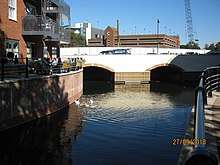
The waterways that still run through Maidenhead town centre were in the past much larger than today, as the scale of the older structures over the channels demonstrates. In Regency times, the main waterway was known as The Canal. Brunel constructed two separate sets of substantial tunnels (eight in all) to safely carry the water under his GWR railway in c1838. The 1899 OS map shows Chapel Arches having water in three substantial arches, above a large lake at Ives Place where the present library is situated.
Long before today's pound locks were built on the main River Thames, the old waterways were controlled by 'flash locks', consisting of sluices or weirs with removable sections. Barges are believed to have once operated from wharves on both the main river and its side channels. Parts of the waterway are thought to have been in active use up to at least the 1920s, witness statements recalling having seen reeds being cut for thatching and also timber being unloaded from a barge at Willow Wharf in the Moor Cut channel on Town Moor. Kelly's Directory for Berkshire 1939 lists a builders merchants "Grace C.W.& Co operating from Willow Wharf in Bridge Street" and the signs for Graces can still be seen on the channel wall by the Police station at Town Moor.
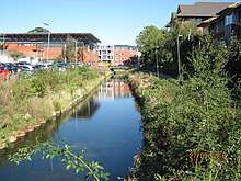
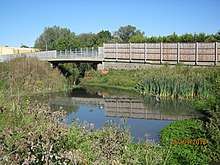
The channel which crosses Town Moor was enlarged in the 1960s as part of the then flood defence system, some time before the Jubilee River was completed in 2002, providing flood relief to Maidenhead and making the previous flood defence system redundant.. The two channels re-join at Green Lane and from there the waterway running down to the Thames is already 45 to 50 feet (14 to 15 m) wide, but overgrown and partly silted up. Channel clearance work over the last few years by volunteers has removed most of the tree blockages and it is now usable (albeit still with some challenges) by canoes and rowing boats.
In recent years the York Stream channel in the centre of Maidenhead had become narrow, shallow and prone to dry out at times of low flow on the main River Thames that feeds it. Under its previous flood protection role, the adjoining Moor Cut channel was kept permanently 'dry' except in flood conditions.[2]
Restoration
By October 2008, a long-term renewal scheme was in progress, aiming to restore and upgrade the old waterways and allow boats into the centre of Maidenhead. The Maidenhead Waterways Group (MW) had been founded in 2006, and became a charity and private company limited by guarantee in March 2007,[3] with the aim of restoring the waterways to a navigable standard, allowing boats to travel into and around the town centre 'Ring'. A lock and weir at Green Lane was to raise and stabilize water levels in the town centre channels and permanently fill the dry Moor Cut channel of the waterway.
The Royal Borough of Windsor and Maidenhead set up the Partnership for the Rejuvenation of Maidenhead (PRoM) in 2006, which developed and proposed a 20 Year Vision and Action Plan for rejuvenating the town centre. The comprehensive Area Action Plan was adopted in 2011, after successive consultations. It sees the restored waterway as one of the defining projects which will help improve and shape the identity of the town for the future.[4]
A planning application for Phase 1 of the waterways works was submitted to the Royal Borough by MW in August 2011 and consent granted in December 2012 subject to conditions. The project then moved on to the detailed design stage, in parallel with investigation of funding options. Area Action Plan development proposals for some of the key streamside sites which were submitted during 2012 have since been approved and are underway. These sites are helping fund implementation of the waterway - from which they benefit by acquiring a water outlook.[5] By mid-2014, Stage 1 of the waterway project, covering the section between the dual carriageway and the Great Western Railway arches, was fully scoped, and a contract awarded to specialist water and environmental contractor Greenford Ltd.[6] Work on this first stage of the build began in early 2015, with the flow being diverted by a temporary dam down the usually empty Moor Cut channel. The works were initially funded by money from the Thames Valley Local Enterprise Partnership’s Growing Places loan fund, and then by Section 106 money resulting from developments in the town centre.
In December 2015 the Royal Borough Royal Borough of Windsor and Maidenhead announced its intention to directly fund another (£3m) stage of the build (Stage 2), allowing the 1 km long York Stream arm of Maidenhead's waterway 'Ring' to be completed, including a weir (with fish pass and boat rollers) to lift the surface water level throughout the town centre.[7]
An aerial and drone video demonstrating progress as at March 2017 was produced with the assistance of an amateur pilot.[8] When Phase 1 is completed with the new landscaping in late 2018 or early 2019, small boats will be able to use this half of the ring, whilst the habitats are re-establishing. In parallel with Stage 1 of the waterway build, Shanly Homes has completed the first two phases of a major residential-led development at Chapel Arches, set around a large water basin at this location of the waterway. The development is enhanced by the waterside setting created by the waterway. Shanly Homes is contributing to the cost of the waterway build and has also built an informal 200 seat waterside amphitheatre for public use next to the Library and the new footbridge over the channel.[9] The third phase of Shanly Homes’ development, which lies immediately to the north of Chapel Arches (High Street), commenced in early 2018, when the final linking section of the York Stream arm of the waterway ’Ring’ will also be constructed.[10]
Once the weir and fish pass at Green Lane are operational, the water in both the York Stream and Moor Cut channels will be raised to their final level, with York Stream generally having a 1.3m water depth (less under certain bridges), but Moor Cut remaining quite shallow until the bed there is also lowered in Stage 3. Phase 2 of the waterway project will include lowering the hard inverts under certain road bridges and over a period of time, lifting other crossings to increase headroom and the standard of navigation able to use the restored waterway.
The Maidenhead Waterways project is a core component of the York Road and Reform Road areas of Maidenhead, which are being rejuvenated by the RBWM Council in a joint venture partnership with Countryside, a UK home builder specializing in place making and urban regeneration.[11]
In due course, Maidenhead Waterways will be seeking funding to improve the southern channel (Bray Cut) which already links the ‘Ring’ to the River Thames at Bray Marina. This channel was enlarged in the 1960s as part of the town’s flood defences, but has silted up since and is very overgrown.[12]
Route
Maidenhead Waterways | |||||||||||||||||||||||||||||||||||||||||||||||||||||||||||||||||||||||||||||||||||||||||||||||||||||||||||||||||||||||||||||||||||||||||||||||||||||||||||||||||||||||||||||||||||||||||||||||||||||||||||||||||||||||||||||||||||||||||||||||||||||||||||||||||||||||||||||||||||||||||||||||||||||||||||||||||||||||||||||||||||||||||||||||||||||||||||||||||||||||||||||||||||||||||||||||||||||||||||||||||||||||||||||||||||||||||||||||||||||||||||||||||||||||||||||||||||||||||||||||||||||||||||||||||||||||||||||||||||||||||||||||||||||||||||||
|---|---|---|---|---|---|---|---|---|---|---|---|---|---|---|---|---|---|---|---|---|---|---|---|---|---|---|---|---|---|---|---|---|---|---|---|---|---|---|---|---|---|---|---|---|---|---|---|---|---|---|---|---|---|---|---|---|---|---|---|---|---|---|---|---|---|---|---|---|---|---|---|---|---|---|---|---|---|---|---|---|---|---|---|---|---|---|---|---|---|---|---|---|---|---|---|---|---|---|---|---|---|---|---|---|---|---|---|---|---|---|---|---|---|---|---|---|---|---|---|---|---|---|---|---|---|---|---|---|---|---|---|---|---|---|---|---|---|---|---|---|---|---|---|---|---|---|---|---|---|---|---|---|---|---|---|---|---|---|---|---|---|---|---|---|---|---|---|---|---|---|---|---|---|---|---|---|---|---|---|---|---|---|---|---|---|---|---|---|---|---|---|---|---|---|---|---|---|---|---|---|---|---|---|---|---|---|---|---|---|---|---|---|---|---|---|---|---|---|---|---|---|---|---|---|---|---|---|---|---|---|---|---|---|---|---|---|---|---|---|---|---|---|---|---|---|---|---|---|---|---|---|---|---|---|---|---|---|---|---|---|---|---|---|---|---|---|---|---|---|---|---|---|---|---|---|---|---|---|---|---|---|---|---|---|---|---|---|---|---|---|---|---|---|---|---|---|---|---|---|---|---|---|---|---|---|---|---|---|---|---|---|---|---|---|---|---|---|---|---|---|---|---|---|---|---|---|---|---|---|---|---|---|---|---|---|---|---|---|---|---|---|---|---|---|---|---|---|---|---|---|---|---|---|---|---|---|---|---|---|---|---|---|---|---|---|---|---|---|---|---|---|---|---|---|---|---|---|---|---|---|---|---|---|---|---|---|---|---|---|---|---|---|---|---|---|---|---|---|---|---|---|---|---|---|---|---|---|---|---|---|---|---|---|---|---|---|---|---|---|---|---|---|---|---|---|---|---|---|---|---|---|---|---|---|---|---|---|---|---|---|---|---|---|---|---|---|---|---|---|---|---|---|---|---|---|---|---|---|---|---|---|---|---|---|---|---|---|---|---|---|---|---|---|---|---|---|---|---|---|---|---|---|---|---|---|---|---|---|---|---|---|---|---|---|---|---|---|---|---|---|---|---|---|---|---|---|---|---|---|---|---|---|---|---|---|---|---|---|---|---|---|---|---|---|---|---|---|---|---|---|---|---|---|---|---|---|---|---|---|---|---|
| |||||||||||||||||||||||||||||||||||||||||||||||||||||||||||||||||||||||||||||||||||||||||||||||||||||||||||||||||||||||||||||||||||||||||||||||||||||||||||||||||||||||||||||||||||||||||||||||||||||||||||||||||||||||||||||||||||||||||||||||||||||||||||||||||||||||||||||||||||||||||||||||||||||||||||||||||||||||||||||||||||||||||||||||||||||||||||||||||||||||||||||||||||||||||||||||||||||||||||||||||||||||||||||||||||||||||||||||||||||||||||||||||||||||||||||||||||||||||||||||||||||||||||||||||||||||||||||||||||||||||||||||||||||||||||||
The route of the complete waterway starts at the Thames near Cliveden Reach, running via the White Brook (Widbrook) across Cookham Moor (fed by a small stream known as Fleet Ditch), to the junction with Strand Water. It then runs southwards via Maidenhead Ditch until it splits at Town Moor into York Stream and Moor Cut. York Stream passes to the west through Maidenhead town centre. The previous flood role of the Moor Cut channel to the east, which is usually dry, was overtaken by the Jubilee River scheme. The two sections re-join at Green Lane where they become a channel known as The Cut (or Bray Cut to differentiate this section from the main section of The Cut, Berkshire which flows into the River Thames at Bray Marina.
The footpath that follows the existing N-S (York Stream) waterside corridor is known as "The Green Way".[13] As part of the consented scheme, a second footpath is to be provided along the length of the hidden Moor Cut channel, to complete a waterside path around the completed ‘Ring’.
See also
References
- ↑ "Maidenhead waterways history". maidenheadwaterways.org. Retrieved 2018-09-29.
- ↑ "Maidenhead waterways other information". maidenheadwaterways.org. Retrieved 2018-09-29.
- ↑ "MAIDENHEAD WATERWAYS RESTORATION GROUP - Filing history (free information from Companies House)". Retrieved 2018-01-02.
- ↑ "Planning application to RBWM". rbwm.gov.uk. Retrieved 2018-09-29.
- ↑ "Green light given for Maidenhead waterways restoration". Retrieved 2018-01-02.
- ↑ "York Stream Archives - Greenford". Greenford. Retrieved 2018-01-02.
- ↑ "Maidenhead Waterways – Completion of York Stream and Weir" (PDF).
- ↑ Richard Davenport (2017-04-10), Maidenhead Waterways - Aerial & Drone Progress Snapshot - March 2017, retrieved 2018-01-05
- ↑ "Maidenhead set for big changes in 2017 as developments take shape". Retrieved 2018-01-05.
- ↑ "Artist impressions show next stages of Chapel Arches development". Retrieved 2018-01-05.
- ↑ "RBWM announcement". rbwm.gov.uk. Retrieved 2018-09-29.
- ↑ "Maidenhead Waterways - Future Plans". www.maidenheadwaterways.org. Retrieved 2018-01-05.
- ↑ Maidenhead, The Royal Borough of Windsor and. "Leaflet : The Green Way Walks | The Royal Borough of Windsor and Maidenhead". www3.rbwm.gov.uk. Retrieved 2018-01-05.
External links
- House of Commons debate on Thames Flood Alleviation Scheme
- Maidenhead Advertiser, 17/05/07, quoting Maidenhead Civic Society
- Maidenhead Waterways Restoration Group
- Maidenhead Civic Society on York Stream
| Next confluence upstream | River Thames | Next confluence downstream |
| River Wye (north) | Maidenhead Waterways | Clewer Mill Stream (south) |