Kirk Yetholm
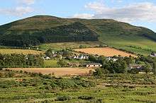
Kirk Yetholm is a village in the Scottish Borders region of Scotland, 8 miles (13 km) south east of Kelso and less than 1 mile (1.6 km) west of the border. The first mention is of its church in the 13th century. Its sister town is Town Yetholm which lies half a mile across the Bowmont Water. The population of the two villages was recorded as 591 in the 2001 census.[1]
The Border Hotel public house is the official end of the Pennine Way. Kirk Yetholm was for centuries the headquarters of the Romani people (Gypsies) in Scotland. The last king of the Gypsies was crowned in 1898 and the Gypsies have been integrated and are no longer a separate ethnic minority. A memorial stone can be found on the village green.[2]
A song referring to Kirk Yetholm called ‘Yetholm Day’ was written and composed by Frankie Mallen of Kelso for the ‘Kelso Civic Week’ celebrations in 2008. It was later covered by local man Gary Cleghorn.
Place-name meanings
Yetholm means either:
- the goats' island from Old English gat 'goat' and Old Norse holmr (island, holme)
- village with a gate - from Old English geat-ham ‘gate village’
Hostel
In 1942 the village school building was converted into a Scottish Youth Hostels Association hostel. It now continues in use as an affiliate hostel named the Kirk Yetholm Friends of Nature House. It provides accommodation for tourists, particularly, walkers and cyclists, and is a suitable stopping point on St Cuthbert's Way, the Pennine Way, and the Sustrans National Cycle Route 1 and Scottish Borders Loop.[3]
See also
Further reading
The Kirk Yetholm Gypsies is available from the Hawick Archaeological Society website.[4]
Footnotes
- ↑ Scotland's Census Result OnLine Archived 2012-03-22 at the Wayback Machine.
- ↑ The Gypsy Memorial, Kirk Yetholm, Scotland
- ↑ "Kirk Yetholm". SYHA Hostelling Scotland. Retrieved 1 August 2016.
- ↑ "Archived copy". Archived from the original on 2011-09-03. Retrieved 2010-05-17.
External links
| Wikimedia Commons has media related to Kirk Yetholm. |
| Wikivoyage has a travel guide for Kirk Yetholm. |