Xingu Indigenous Park
| Xingu Indigenous Park | |
|---|---|
| Parque Indígena do Xingu | |
|
IUCN category II (national park) | |
 | |
| Coordinates | 11°13′55″S 53°11′06″W / 11.232°S 53.185°WCoordinates: 11°13′55″S 53°11′06″W / 11.232°S 53.185°W |
| Area | 2,642,003 hectares (6,528,530 acres) |
| Designation |
national park Indigenous Territory |
| Created | 14 April 1961 |
| Administrator | ICMBio |
The Xingu Indigenous Park (Portuguese: Parque Indígena do Xingu, pronounced [ʃĩˈɡu]) is an indigenous territory of Brazil, first created in 1961 as a national park in the state of Mato Grosso, Brazil. Its official purposes are to protect the environment and the several tribes of Xingu indigenous peoples in the area.
Location
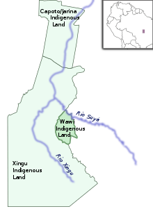
The Xingu Indigenous Park is in the north east of the state of Mato Grosso, in the south of the Amazon biome. It covers 2,642,003 hectares (6,528,530 acres), with savannah and drier semi-deciduous forests in the south transitioning to Amazon rain forest in the north. There is a rainy season from November to April. The headwaters of the Xingu River are in the south of the park. The area covered by the park was defined in 1961 and covers parts of the municipalities of Canarana, Paranatinga, São Félix do Araguaia, São José do Xingu, Gaúcha do Norte, Feliz Natal, Querência, União do Sul, Nova Ubiratã and Marcelândia in the state of Mato Grosso.[1]
History
The national park was created after a campaign by the Villas-Bôas brothers for protection of the region. An account of the exploration of this area by the Villas-Bôas brothers and their efforts to protect the region is documented in the film Xingu (2012).
The idea of creating a park originated with a round table organized by the vice president of Brazil in 1952, at which a much larger park was proposed. However, the state of Mato Grosso began granting land within the proposed area to colonizing companies, so the park that came into existence by decree 50.455 of 14 April 1961 was only a quarter of the proposed size. Adjustments were made on 31 July 1961, 6 August 1968 and 13 July 1971. The final demarcation of the perimeter was made in 1978. The area was given the designation of "National Park" to cover the dual purpose of protecting the environment and the indigenous people, and is subject to both the indigenous agency and the environmental agency. In 1967 the term "National Park" was replaced by "Indigenous Park" to reflect the primary goal of protecting the social diversity of the indigenous people.[1]

The park began to suffer from the incursion of fishermen and hunters in the 1980s. By the late 1990s livestock farms to the north east of the park were starting to reach the park, as was deforestation to the west of the park. The effects of human activity outside the park were starting to pollute the waters of the park. The park remains as an island of forest increasingly threatened by activity outside its perimeter.[1]
Peoples
The tribes occupying territories within the boundaries of the park are the Kamayurá (355), Kaiabi (745), Yudjá (248), Aweti (138), Mehinako (199), Wauja (321), Yawalapiti (208), Ikpeng (319), Kalapalo (417), Kuikuro (415), Matipu (119), Nahukwá (105), Suyá (334) and Trumai (120), population figures as of 2002.
The Xingu area is of interest because it was a destination for early-20th century exploration by Europeans, among whom British Captain Percy Harrison Fawcett was the most notable. He sought a city which Europeans had heard rumor of since their early 16th-century colonial contact, and he disappeared in the jungle in 1925.
David Grann wrote an article about his exploration, followed by an expanded book, The Lost City of Z (2009) on the same subject and with the same title. It documents those early explorations. It also explores archeological evidence found since the late 20th century of large-scale indigenous civilizations that pre-date Spanish and Portuguese contacts and colonization.
Notes
Sources
- O Parque (in Portuguese), ISA: Instituto Socioambiental, retrieved 2016-05-05
| Wikimedia Commons has media related to Parque Indígena do Xingu. |