Wyoming Basin physiographic province
| Wyoming Basin | |
| physiographic province | |
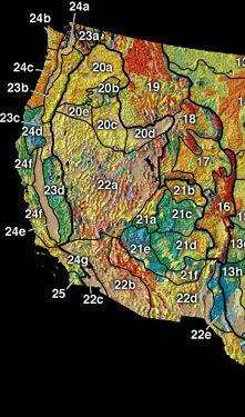 The Wyoming Basin (17) includes the Great Divide Basin. | |
| Country | United States |
|---|---|
| State | Wyoming |
| Part of | Rocky Mountain System |
The Wyoming Basin physiographic province is a geographic area through which the Continental Divide of the Americas traverses. The province includes the Washakie Basin[1] and Great Divide Basins, and is demarcated by the following:
- southwest: Uinta Mountains
- west: west side of Green River watershed
|
|
See also
References
- ↑ "Select Area of Interest". [Wyoming Stratigraphy]. Wyoming State Geological Survey. Retrieved 2010-04-24. (Great Basin Divide, Washakie Basin)
Coordinates: 42°31′24″N 109°39′09″W / 42.523422°N 109.652504°W
This article is issued from
Wikipedia.
The text is licensed under Creative Commons - Attribution - Sharealike.
Additional terms may apply for the media files.