Win Green Down
| Win Green | |
|---|---|
 Wingreen Hill the highest point of Cranborne Chase an area of Outstanding Natural Beauty in Wiltshire, England | |
| Highest point | |
| Elevation | 277 m (909 ft) |
| Coordinates | 50°59′08″N 2°06′29″W / 50.9856°N 2.1081°WCoordinates: 50°59′08″N 2°06′29″W / 50.9856°N 2.1081°W |
| Geography | |
 Win Green Win Green in Wiltshire | |
| Location |
Wiltshire, |
| Parent range | North Wessex Downs |
| OS grid | ST927209 |
| Topo map | OS Landranger 184 |
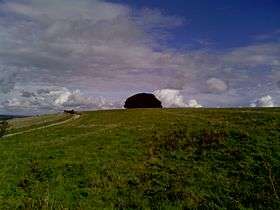
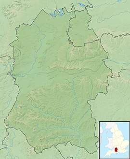
Win Green Down (277 metres (909 ft), grid reference ST927209) in south-western Wiltshire is a 26.0 hectare biological Site of Special Scientific Interest in Wiltshire, notified in 1971. The summit, Win Green, is at grid ST924205 and is the highest point of Cranborne Chase. There are extensive views, with Bournemouth, the Isle of Wight, Salisbury, and Glastonbury Tor, the Mendips, the Quantocks and Milk Hill all visible in clear conditions. It is classed as a Marilyn, and is a well-known landmark due to the clump of trees on the highpoint.
Sources
- English Nature citation sheet for the site (accessed 8 August 2006)
- http://www.ukhillwalking.com/logbook/hill.php?id=14024
- Mapping: OS Explorer 118 (1:25 000), OS Landranger 184 (1:50 000)
External links
- English Nature website (SSSI information)
- http://www.ukhillwalking.com/logbook/hill.php?id=14024
This article is issued from
Wikipedia.
The text is licensed under Creative Commons - Attribution - Sharealike.
Additional terms may apply for the media files.