Kaiser Wilhelm II Land
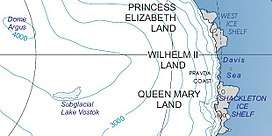
Kaiser Wilhelm II Land (also Wilhelm II Coast) is the part of Antarctica lying between Cape Penck, at 87°43'E, and Cape Filchner, at 91°54'E and is claimed as part of the Australian Antarctic Territory, although this claim is not universally recognized.
The area was discovered on February 22, 1902 during the Gauss expedition (1901-1903), led by Arctic veteran and geology professor Erich von Drygalski. Drygalski named it after Kaiser Wilhelm II[1] who had funded the expedition with 1.2 million Goldmarks.
In the bay where Drygalski's expedition had their camp until February 8, 1903 is Gaussberg, a 370 metre high extinct volcano which was named after the mathematician and physicist Carl Friedrich Gauss.
References
- ↑ "Wilhelm II Coast". Geographic Names Information System. United States Geological Survey. Retrieved 2013-04-12.
![]()
Coordinates: 67°0′S 90°0′E / 67.000°S 90.000°E