Wiener Neustadt Canal
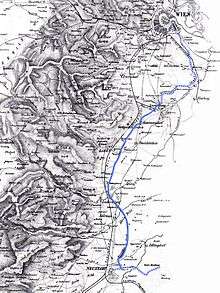
Image 1: Map of the Wiener Neustadt Canal circa 1875. The solid blue line indicates the portion that remains in 2007.
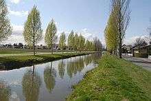
The Wiener Neustadt Canal in 2007.
The Wiener Neustadt Canal was Austria's only shipping canal, originally meant to reach to Trieste. It became operational in 1803 and ceased to be used for transportation before World War I.
References
- Fritz Lange: Von Wien zur Adria – Der Wiener Neustädter Kanal, 2003, ISBN 3-89702-621-X
- Valerie Else Riebe: Der Wiener Neustädter Schiffahrtskanal, 1936
External links
| Wikimedia Commons has media related to Wiener Neustädter Kanal. |
- The Wiener Neustadt Canal
- Josef Kovats: Documentary Trailer (German)
- Heinrich Tinhofer: WalkingInside - Forum Canal Independent Initiative for Revitalising the Canal (automatically translated).
Coordinates: 48°04′31″N 16°20′59″E / 48.07528°N 16.34972°E
This article is issued from
Wikipedia.
The text is licensed under Creative Commons - Attribution - Sharealike.
Additional terms may apply for the media files.