Horton, Northumberland
| Horton | |
|---|---|
 East Horton | |
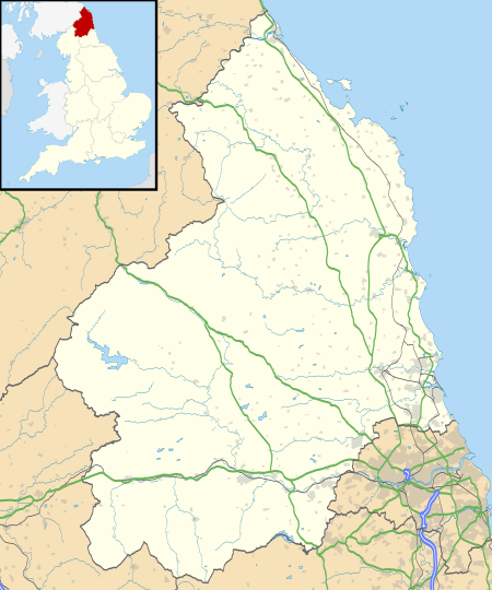 Horton Horton shown within Northumberland | |
| OS grid reference | NU028309 |
| District | |
| Shire county | |
| Region | |
| Country | England |
| Sovereign state | United Kingdom |
| Post town | WOOLER |
| Postcode district | NE71 |
| Police | Northumbria |
| Fire | Northumberland |
| Ambulance | North East |
| EU Parliament | North East England |
| UK Parliament | |
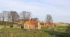
Horton is a pair of small settlements, West Horton and East Horton, divided by a stream - the Horton Burn - in Northumberland, England 3 miles (5 km) north east of Wooler and 5 miles (8 km) west of Belford.
It is first attested as Horton' (Turbervill) ('Horton held by the Turbervill family') in 1242. The place-name Horton is a common one in England. It derives from Old English horu 'dirt' and tūn 'settlement, farm, estate', presumably meaning 'farm on muddy soil'.[1]
Landmarks
The Devil's Causeway passes through the village and continues north under a C Road for about 6 miles (10 km) to Lowick. The causeway is a Roman road which starts at Port Gate on Hadrian's Wall, north of Corbridge, and extends 55 miles (89 km) northwards across Northumberland to the mouth of the River Tweed at Berwick-upon-Tweed.
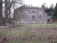
Two miles to the north of the village is Hetton Hall, which comprises a 15th-century pele tower with 18th and 19th century additions.[2]
A little over a mile to the south-west, Weetwood Hall is another medieval tower house, altered and extended in the 18th and 19th centuries.[3]
References
- ↑ Victor Watts (ed.), The Cambridge Dictionary of English Place-Names, Based on the Collections of the English Place-Name Society (Cambridge: Cambridge University Press, 2004), s.v. HORTON.
- ↑ Hetton Hall at British Listed Buildings Online
- ↑ Weetwood Hall at British Listed Buildings Online
External links
![]()