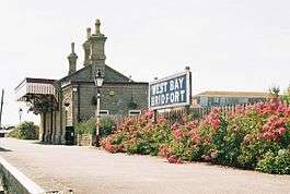
Bridport West Bay railway station
| Bridport West Bay | |
|---|---|
 Former railway station | |
| Location | |
| Place | Bridport |
| Area | West Dorset |
| Grid reference | SY465904 |
| Operations | |
| Pre-grouping |
Bridport Railway GWR |
| Post-grouping |
GWR Western Region of British Railways |
| Platforms | 1 |
| History | |
| 31 March 1884 | Opened |
| 1 January 1916 | Closed |
| 5 January 1920 | Reopened |
| 11 April 1921 | Closed |
| 11 July 1921 | Reopened |
| 22 September 1924 | Closed |
| 6 October 1924 | Reopened |
| 22 September 1930 | Closed for passengers |
| 1962 | closed for freight traffic |
| Disused railway stations in the United Kingdom | |
|
Closed railway stations in Britain A B C D–F G H–J K–L M–O P–R S T–V W–Z | |
|
| |
West Bay railway station was the terminus of the Bridport Railway in western Dorset, England. In 1879, the Great Western Railway, who held the operating licence for the original Bridport Railway (which ran as far as Bridport town), decided to extend the railway to Bridport Harbour. Construction started in 1883, and the line opened on 31 March 1884. The station was called West Bay by the GWR in order to encourage holiday traffic. The line between West Bay and Bridport closed to passengers in 1930, and operated for goods services only until its final closure in 1962.[1]
The site today

After many years as the office of a boat yard, in 1995 the station was restored with a short length of track at the platform. The station building has operated sporadically as a cafe since then.[2] From West Bay, a section of the former track bed can now be walked into Bridport.
| Preceding station | Disused railways | Following station | ||
|---|---|---|---|---|
| East Street (Bridport) Line and station closed |
Great Western Railway Bridport Railway |
Terminus | ||
References
- ↑ Bridport Railway at westbay.co.uk
- ↑ "Disused Stations: Bridport West Bay Station". Subbrit.org.uk. Retrieved 2013-09-15.
- Butt, R. V. J. (1995). The Directory of Railway Stations: details every public and private passenger station, halt, platform and stopping place, past and present (1st ed.). Sparkford: Patrick Stephens Ltd. ISBN 978-1-85260-508-7. OCLC 60251199.
- Jowett, Alan (2000). Jowett's Nationalised Railway Atlas (1st ed.). Penryn, Cornwall: Atlantic Transport Publishers. ISBN 978-0-906899-99-1. OCLC 228266687.
- Jowett, Alan (March 1989). Jowett's Railway Atlas of Great Britain and Ireland: From Pre-Grouping to the Present Day (1st ed.). Sparkford: Patrick Stephens Ltd. ISBN 978-1-85260-086-0. OCLC 22311137.
- Station on navigable O.S. map
Coordinates: 50°42′40″N 2°45′32″W / 50.7111°N 2.7588°W