Werunda County

Werunda
New South Wales
Location in New South Wales
Lands administrative divisions around Werunda:
Young Killara Rankin
Young Werunda Rankin
Livingstone Woore Woore

Werunda County is one of the 141 Cadastral divisions of New South Wales. The Darling River is the north-western boundary. It includes Poopelloe Lake, and the area to the east and south-east of Wilcannia.

The name Werunda is believed to be derived from a local Aboriginal word.[1]

Parishes within this county

A full list of parishes found within this county; their current LGA and mapping coordinates to the approximate centre of each location is as follows:
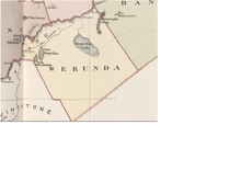
Map of Werunda County, Far west New South Wales from John Sands 1886 Atlas of Australia.
ParishLGACoordinates
CalcooCentral Darling Shire31°39′10″S 143°35′22″E / 31.65278°S 143.58944°E / -31.65278; 143.58944 (Calcoo)
CaltigeenaaCentral Darling Shire31°34′55″S 143°52′00″E / 31.58194°S 143.86667°E / -31.58194; 143.86667 (Caltigeenaa)
ChanceCentral Darling Shire31°30′13″S 144°04′53″E / 31.50361°S 144.08139°E / -31.50361; 144.08139 (Chance)
ChirnsideCentral Darling Shire31°57′38″S 143°45′13″E / 31.96056°S 143.75361°E / -31.96056; 143.75361 (Chirnside)
CoolmaraCentral Darling Shire32°05′22″S 143°49′30″E / 32.08944°S 143.82500°E / -32.08944; 143.82500 (Coolmara)
CoonavittraCentral Darling Shire31°43′05″S 144°18′23″E / 31.71806°S 144.30639°E / -31.71806; 144.30639 (Coonavittra)
CoonoolcraCentral Darling Shire31°47′18″S 143°35′16″E / 31.78833°S 143.58778°E / -31.78833; 143.58778 (Coonoolcra)
CowaryCentral Darling Shireunknown
CultowaCentral Darling Shire31°53′50″S 144°05′40″E / 31.89722°S 144.09444°E / -31.89722; 144.09444 (Cultowa)
CurranyaleCentral Darling Shireunknown
DonaldCobar Shire31°50′34″S 144°20′34″E / 31.84278°S 144.34278°E / -31.84278; 144.34278 (Donald)
DunoonCentral Darling Shire31°31′41″S 143°37′36″E / 31.52806°S 143.62667°E / -31.52806; 143.62667 (Dunoon)
GoonalgaaCentral Darling Shire31°45′50″S 143°41′28″E / 31.76389°S 143.69111°E / -31.76389; 143.69111 (Goonalgaa)
GreenoughCentral Darling Shire31°34′29″S 144°13′15″E / 31.57472°S 144.22083°E / -31.57472; 144.22083 (Greenough)
GunyulkaCentral Darling Shire31°41′55″S 143°29′55″E / 31.69861°S 143.49861°E / -31.69861; 143.49861 (Gunyulka)
KeissCentral Darling Shire31°30′51″S 143°44′26″E / 31.51417°S 143.74056°E / -31.51417; 143.74056 (Keiss)
ManaraCentral Darling Shire32°11′23″S 143°50′39″E / 32.18972°S 143.84417°E / -32.18972; 143.84417 (Manara)
MerryCentral Darling Shire31°25′16″S 144°01′55″E / 31.42111°S 144.03194°E / -31.42111; 144.03194 (Merry)
MoiraCentral Darling Shire31°52′54″S 143°54′57″E / 31.88167°S 143.91583°E / -31.88167; 143.91583 (Moira)
MurteeCentral Darling Shire31°36′34″S 143°31′26″E / 31.60944°S 143.52389°E / -31.60944; 143.52389 (Murtee)
ParadiseCentral Darling Shire31°59′18″S 143°51′37″E / 31.98833°S 143.86028°E / -31.98833; 143.86028 (Paradise)
PoopelloeCentral Darling Shire31°40′14″S 144°09′22″E / 31.67056°S 144.15611°E / -31.67056; 144.15611 (Poopelloe)
RingroseCentral Darling Shire32°02′43″S 144°01′15″E / 32.04528°S 144.02083°E / -32.04528; 144.02083 (Ringrose)
TalyawalkaCentral Darling Shire31°35′48″S 143°41′28″E / 31.59667°S 143.69111°E / -31.59667; 143.69111 (Talyawalka)
WarwickCobar Shire31°56′19″S 144°01′33″E / 31.93861°S 144.02583°E / -31.93861; 144.02583 (Warwick)
WeatherleyCentral Darling Shire31°45′37″S 143°51′16″E / 31.76028°S 143.85444°E / -31.76028; 143.85444 (Weatherley)
WeeyoolaCentral Darling Shire31°46′05″S 144°09′13″E / 31.76806°S 144.15361°E / -31.76806; 144.15361 (Weeyoola)
WerundaCentral Darling Shire31°29′34″S 143°50′56″E / 31.49278°S 143.84889°E / -31.49278; 143.84889 (Werunda)
Wilcannia SouthCentral Darling Shire31°36′12″S 143°23′41″E / 31.60333°S 143.39472°E / -31.60333; 143.39472 (Wilcannia South)
WongolarrooCentral Darling Shire31°39′11″S 143°57′20″E / 31.65306°S 143.95556°E / -31.65306; 143.95556 (Wongolarroo)
WooreCobar Shireunknown
WoytchuggaCentral Darling Shire31°43′17″S 143°23′13″E / 31.72139°S 143.38694°E / -31.72139; 143.38694 (Woytchugga)
YoreeCentral Darling Shire31°44′13″S 144°01′56″E / 31.73694°S 144.03222°E / -31.73694; 144.03222 (Yoree)

References

  1. "Werunda County". Geographical Names Register (GNR) of NSW. Geographical Names Board of New South Wales.
This article is issued from Wikipedia. The text is licensed under Creative Commons - Attribution - Sharealike. Additional terms may apply for the media files.