Watkinsville, Georgia
| Watkinsville, Georgia | |
|---|---|
| Town | |
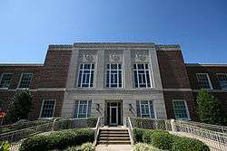 Oconee County Courthouse in Watkinsville, Georgia | |
 Location in Oconee County and the state of Georgia | |
| Coordinates: 33°51′46″N 83°24′29″W / 33.86278°N 83.40806°WCoordinates: 33°51′46″N 83°24′29″W / 33.86278°N 83.40806°W | |
| Country | United States |
| State | Georgia |
| County | Oconee |
| Area | |
| • Total | 3.2 sq mi (8.3 km2) |
| • Land | 3.2 sq mi (8.3 km2) |
| • Water | 0 sq mi (0 km2) |
| Elevation | 719 ft (219 m) |
| Population (2010) | |
| • Total | 2,832 |
| • Estimate (2016)[1] | 2,863 |
| • Density | 654/sq mi (252.7/km2) |
| Time zone | UTC-5 (Eastern (EST)) |
| • Summer (DST) | UTC-4 (EDT) |
| ZIP code | 30677 |
| Area code(s) | 706 |
| FIPS code | 13-80788[2] |
| GNIS feature ID | 0333373[3] |
| Website | http://cityofwatkinsville.com/ |
Watkinsville is the largest city and seat of Oconee County, Georgia, United States. As of the 2010 census, the town had a total population of 2,832.[4] It served as the seat of Clarke County until 1872 when the county seat of that county was moved to Athens, a move which ultimately led to the creation of Oconee County in 1875. It is included in the Athens-Clarke County, Georgia Metropolitan Statistical Area.
Geography
Watkinsville is located at 33°51′46″N 83°24′29″W / 33.86278°N 83.40806°W (33.862818, -83.408094).[5]
According to the United States Census Bureau, the town has a total area of 3.2 square miles (8.3 km2), of which 3.2 square miles (8.3 km2) is land and 0.31% is water.
Transportation
Major roads
Pedestrians and cycling
The city has limited walkability options available. However, since 2017 plans are being discussed to develop a multi-use trail network.[6]
Demographics
| Historical population | |||
|---|---|---|---|
| Census | Pop. | %± | |
| 1810 | 224 | — | |
| 1870 | 643 | — | |
| 1880 | 350 | −45.6% | |
| 1890 | 314 | −10.3% | |
| 1900 | 351 | 11.8% | |
| 1910 | 483 | 37.6% | |
| 1920 | 465 | −3.7% | |
| 1930 | 425 | −8.6% | |
| 1940 | 558 | 31.3% | |
| 1950 | 662 | 18.6% | |
| 1960 | 758 | 14.5% | |
| 1970 | 986 | 30.1% | |
| 1980 | 1,240 | 25.8% | |
| 1990 | 1,600 | 29.0% | |
| 2000 | 2,097 | 31.1% | |
| 2010 | 2,832 | 35.1% | |
| Est. 2016 | 2,863 | [1] | 1.1% |
| U.S. Decennial Census[7] | |||
As of the census[2] of 2000, there were 2,097 people, 827 households, and 578 families residing in the town. The population density was 650.6 people per square mile (251.4/km²). There were 862 housing units at an average density of 267.4 per square mile (103.4/km²). The racial makeup of the town was 89.08% White, 7.34% African American, 0.05% Native American, 1.62% Asian, 0.48% Pacific Islander, 0.86% from other races, and 0.57% from two or more races. Hispanic or Latino of any race were 1.96% of the population.
There were 827 households out of which 36.5% had children under the age of 18 living with them, 53.6% were married couples living together, 12.7% had a female householder with no husband present, and 30.1% were non-families. 24.4% of all households were made up of individuals and 8.5% had someone living alone who was 65 years of age or older. The average household size was 2.51 and the average family size was 2.99.
In the town, the population was spread out with 26.8% under the age of 18, 8.6% from 18 to 24, 33.0% from 25 to 44, 22.7% from 45 to 64, and 8.9% who were 65 years of age or older. The median age was 34 years. For every 100 females, there were 92.7 males. For every 100 females age 18 and over, there were 91.5 males.
The median income for a household in the town was $45,729, and the median income for a family was $55,170. Males had a median income of $32,295 versus $26,168 for females. The per capita income for the town was $20,968. About 3.8% of families and 5.0% of the population were below the poverty line, including 5.9% of those under age 18 and 4.7% of those age 65 or over.
Early history
In 1802, Watkinsville, originally known as the "Big Springs" community, was named after Colonel Robert Watkins of Augusta, a lawyer and early compiler of A Digest of the Laws of the State of Georgia through 1799. Watkinsville was a village located on the dangerous western frontier of the new United States between Creek and Cherokee territories. Eagle Tavern, believed to stand on the site of the old Fort Edward, opened in 1801 and today serves as a museum commemorating the era of wagon and stage travel. Watkinsville first appeared in Clarke County records in 1791; only fifty-eight years after James Edward Oglethorpe founded the colony of Georgia. In 1802, John Cobb gave up eight lots of his plantation to create the city. And on November 24, 1806 the City became the Incorporated Town of Watkinsville. It then became the seat for Clarke County and remained so until 1872, when Athens took over that role. Angry locals voted to create a new county, named after the Oconee River on its eastern border, and Watkinsville became its seat on February 25, 1875.
Government
Watkinsville is governed by a five-person elected city council, which is led by a separately elected mayor. The current mayor is Charles Ivie (having defeated Dan Matthews in the first contested mayoral race in more than 20 years in 2011), and the current city council members are Brian Brodrick, Vice Mayor Connie Massey, Marci Campbell, Christine Tucker, and Dan Matthews. Matthews was elected in 2016 by a two-vote margin over Mark Melvin. The current police chief is Lee O'Dillon. The city clerk is Julie Sanders, who was also the Marshall for the 2015 Christmas Parade.
Education
The Oconee County School District provides primary and secondary public education services for all residents of Watkinsville.[8] The only public school within the Watkinsville city limits is Colham Ferry Elementary School.
List of Mayors
- David Shearon current mayor
- Charles Ivie, former mayor
- Joseph Walter, former Mayor and police officer Athens-Clarke County
- James "Jim" T. Luken, Jr., former Mayor and member of the United States Marine Corps who saw duty in Vietnam.
- Sammy Sanders, former Mayor
Arts and culture
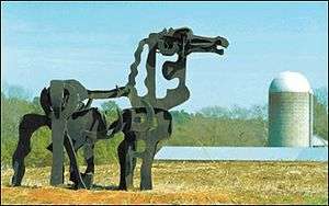
Watkinsville has the unofficial motto "The Artland of Georgia" on the wall of the Community Center, as designed by the late artist Jim Shearon.[9] The Oconee Cultural Arts Foundation or OCAF is located in Watkinsville in the old high school as part of the 1902 OCAF Center and Gallery near the Board of Education. The Iron Horse sculpture stands in a field approximately twelve miles south of Watkinsville.[10]
Notable people
- Alan Busenitz, baseball player
- Ed Crowley, baseball player
- Hank Huckaby, chancellor of University System of Georgia
- Zach Mettenberger, NFL quarterback for Tennessee Titans
- Tony Taylor, pro football player
- Buck Thrasher, baseball player
- John Wes Townley, retired NASCAR driver, notable for driving Zaxby's car
References
- 1 2 "Population and Housing Unit Estimates". Retrieved June 9, 2017.
- 1 2 "American FactFinder". United States Census Bureau. Retrieved 2008-01-31.
- ↑ "US Board on Geographic Names". United States Geological Survey. 2007-10-25. Retrieved 2008-01-31.
- ↑ 2010 Census Population Map
- ↑ "US Gazetteer files: 2010, 2000, and 1990". United States Census Bureau. 2011-02-12. Retrieved 2011-04-23.
- ↑ "Plans for Oconee County taking shape". Gate House Media LLC. 2017-06-14. Retrieved 2018-05-21.
- ↑ "Census of Population and Housing". Census.gov. Retrieved June 4, 2015.
- ↑ Georgia Board of Education, Retrieved June 24, 2010.
- ↑ Matthews Jr., Daniel J (April 28, 2004). "City residents voice concerns over streets | Online Athens". onlineathens.com. Retrieved January 17, 2017.
- ↑ Shearer, Lee (3 June 2015). "Iconic Iron Horse's hooves eaten by rust, but will be repaired". Retrieved 25 June 2016.
External links
- Watkinsville Official Website
- Oconee County Department of Tourism Website
- Watkinsville Web Page at georgia.gov
Municipalities and communities of Oconee County, Georgia, United States | ||
|---|---|---|
| Towns | 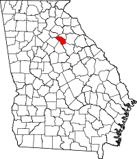 | |
| Unincorporated communities | ||
| Ghost town | ||
| Footnotes | ‡This populated place also has portions in an adjacent county or counties | |