Waldbredimus
| Waldbredimus Waldbriedemes | ||
|---|---|---|
| Commune | ||
 | ||
| ||
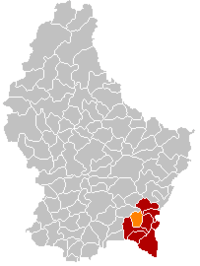 Map of Luxembourg with Waldbredimus highlighted in orange, and the canton in dark red | ||
| Coordinates: 49°33′25″N 6°17′15″E / 49.5569°N 6.2875°ECoordinates: 49°33′25″N 6°17′15″E / 49.5569°N 6.2875°E | ||
| Country |
| |
| Canton | Remich | |
| Government | ||
| • Mayor | Louis Oberhag | |
| Area | ||
| • Total | 12.57 km2 (4.85 sq mi) | |
| Area rank | 89 of 102 | |
| Highest elevation | 359 m (1,178 ft) | |
| • Rank | 80th of 102 | |
| Lowest elevation | 170 m (560 ft) | |
| • Rank | 14th of 102 | |
| Population (2014) | ||
| • Total | 949 | |
| • Rank | 101st of 102 | |
| • Density | 75/km2 (200/sq mi) | |
| • Density rank | 74th of 102 | |
| Time zone | UTC+1 (CET) | |
| • Summer (DST) | UTC+2 (CEST) | |
| LAU 2 | LU00008009 | |
| Website | waldbredimus.lu | |

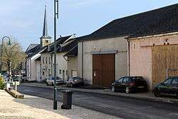
Waldbredimus (Luxembourgish: Waldbriedemes) is a commune and small town in south-eastern Luxembourg. It is part of the canton of Remich, which is part of the district of Grevenmacher. The commune's administrative centre is Trintange.
As of 2005, the town of Waldbredimus, which lies in the centre of the commune, has a population of 376. Other towns within the commune include Ersange and Trintange.
External links

 | ||
This article is issued from
Wikipedia.
The text is licensed under Creative Commons - Attribution - Sharealike.
Additional terms may apply for the media files.