LeMoyne, Quebec
| LeMoyne, Quebec | |
|---|---|
| Neighbourhood | |
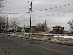 Houses on Saint-Georges Street | |
|
Motto(s): "Droit et Loyal" (French) "Right and Loyal" | |
|
LeMoyne, Quebec Location of LeMoyne in Greater Montreal | |
| Coordinates: 45°30′07″N 73°29′26″W / 45.501889°N 73.490611°W | |
| Country |
|
| Province |
|
| City | Longueuil |
| Borough | Le Vieux-Longueuil |
| Established | 1949 |
| Merger with Longueuil | January 1, 2002 |
| Government | |
| • LeMoyne-Jacques-Cartier City Councillor | Colette Éthier (AL) |
| Area[1][2] | |
| • Land | 1.00 km2 (0.39 sq mi) |
| Population (2011)[2] | |
| • Total | 4,813 |
| • Density | 4,813.0/km2 (12,466/sq mi) |
| • Change * |
|
| • Dwellings | 2,815 |
| Time zone | UTC-5 (Eastern (EST)) |
| • Summer (DST) | UTC-4 (EDT) |
| Area code(s) | 450 |
| Access Routes [3] |
|
LeMoyne (also known as Ville LeMoyne) is a former city on the South Shore of Montreal. It is currently a neighbourhood in Longueuil, Quebec, and is part of the borough of Le Vieux-Longueuil. LeMoyne makes up 2% of the total area of Le Vieux-Longueuil borough and is the only neighbourhood of the borough that was not part of the pre-2002 city of Longueuil. Residents of LeMoyne are called LeMoynois.
The municipal electoral district of LeMoyne-Jacques-Cartier corresponds to the territory of LeMoyne, along with a portion from the former city of Longueuil.
History
Saint-Maxime and Saint-Josaphat
LeMoyne is divided into two sections separated by Route 112. They are Saint-Maxime and Saint-Josaphat, the two Catholic parishes that are the ancestors of LeMoyne.
Route 112 is called Saint-Louis Street in Saint-Maxime. Saint-Maxime has the shape of rectangle and is located from Saint-Louis Street to the limits of Greenfield Park. Saint-Maxime Church, built in 1918, is on Charron Street.
In Saint-Josaphat, Route 112 is called Sir Wilfrid-Laurier Boulevard. Saint-Josaphat has the shape somewhat of a boomerang or a hockey stick, and is located from Sir Wilfrid Laurier Boulevard to the limits of the former city of Longueuil. Saint-Josaphat Church is located on De L'Église Street.
Town of LeMoyne
The town of LeMoyne was created in 1949 from the merger of two parishes, Saint-Josaphat and Saint-Maxime, both of which were previously located in Ville Jacques-Cartier.[4] According to local historian Michel Pratt, the name "LeMoyne" was chosen by Redmond Roche of the Union Nationale, in honour to Charles LeMoyne.
LeMoyne elected in 1981 Louise Gravel as its first female mayor.[5]
Motto
The last of motto of LeMoyne, before its annexation into Longueuil, was Droit et Loyal (English translation: Right and Loyal)
Town hall
Up until 1967, the town hall of LeMoyne was on Saint-Louis Street near Laurier Street. When located there, LeMoyne had its own police and fire stations.
In 1967, the town hall was moved on Saint-Georges Street (corner Charron Street), where it remained until the 2002 merger of LeMoyne with Longueuil. When LeMoyne moved its city hall in 1967, it did away with its police and fire services. From then on, these services were provided to LeMoyne, first by the city of Saint-Lambert, and later by the city of Saint-Hubert.
Today, the city hall on Saint-Georges Street has been converted as a fire station for the city of Longueuil.
Merger to Longueuil
On January 1, 2002, LeMoyne ceased to exist as a municipality and was amalgamated into the city of Longueuil to become part of the Saint-Lambert/LeMoyne borough.
However, on June 20, 2004 Saint-Lambert voted to demerge from Longueuil and on January 1, 2006 regained its status of city, while LeMoyne opted to stay in Longueuil.
After the demergers, LeMoyne joined Le Vieux-Longueuil borough following the results of a 2005 referendum in which the residents of LeMoyne were given the choice to pick a new borough between Le Vieux-Longueuil, Saint-Hubert and Greenfield Park.
Demographics
| Historical populations | ||
|---|---|---|
| Year | Pop. | ±% |
| 1951 | 4,078 | — |
| 1961 | 8,057 | +97.6% |
| 1971 | 8,184 | +1.6% |
| 1981 | 6,137 | −25.0% |
| 1991 | 5,412 | −11.8% |
| 1996 | 5,052 | −6.7% |
| 2001 | 4,855 | −3.9% |
| 2006 | 5,149 | +6.1% |
| 2011 | 4,813 | −6.5% |
| [6][7] | ||
| Language | Population | Percentage (%) |
|---|---|---|
| French | 4,185 | 81.6% |
| English | 440 | 8.6% |
| Both English and French | 30 | 0.6% |
| Other languages | 475 | 9.3% |
Mayors
| Mayor | Term Began | Term Ended |
|---|---|---|
| Henri Sicotte | 1949 | 1952 |
| Albert Bélanger | 1952 | 1954 |
| Jean Baribeau | 1954 | 1967 |
| André Charpentier | 1967 | 1977 |
| Michel Sicotte | 1977 | 1981 |
| Louise Gravel | 1981 | 1993 |
| Guy Talbot | 1993 | 2001 |
| Part of Longueuil | 2002 | present |
Famous people
- Maxime Talbot, Professional Hockey Player for the Boston Bruins
- Josée Lavigueur, Professional fitness instructor
See also
- Michel Pratt, Histoire de la ville de LeMoyne 1949-1999, Société historique et culturelle du Marigot
- Boroughs of Longueuil
- List of mayors of Longueuil, Quebec
- Longueuil City Council
- Longueuil, Quebec
- Municipal reorganization in Quebec
- Urban Agglomeration of Longueuil
- Le Vieux-Longueuil
Coordinates: 45°30′6.8″N 73°29′26.2″W / 45.501889°N 73.490611°W
References
- 1 2 2006 Statistics Canada Community Profile
- 1 2 "Census Profile: Census Tract: 4620866.00". Canada 2011 Census. Statistics Canada. Retrieved 10 July 2012.
"Census Profile: Census Tract: 4620865.00". Canada 2011 Census. Statistics Canada. Retrieved 10 July 2012. - ↑ Official Transport Quebec Road Map
- ↑ http://michelpratt.quebec/47_97/1949.htm
- ↑ http://marigot.ca/lemoyne/html/chapitre4.htm
- ↑ Pratt, Michel. "De la balkanisation des villes à leur fusion". Société historique et culturelle du Marigot. Retrieved 24 October 2013.
- ↑ Statistics Canada: 1996, 2001, 2006, 2011 census