Old Fort, Quebec
| Old Fort | |
|---|---|
| Unconstituted locality | |
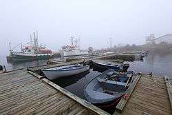 Fishing Harbour of Old Fort | |
 Old Fort | |
| Coordinates: 51°25′25″N 57°49′28″W / 51.42361°N 57.82444°WCoordinates: 51°25′25″N 57°49′28″W / 51.42361°N 57.82444°W[1] | |
| Country |
|
| Province |
|
| Region | Côte-Nord |
| RCM | Le Golfe-du-Saint-Laurent |
| Municipality | Bonne-Espérance |
| Government | |
| • Federal riding | Manicouagan |
| • Prov. riding | Duplessis |
| Area[2] | |
| • Land | 3.01 km2 (1.16 sq mi) |
| Population (2011)[2] | |
| • Total | 350 |
| • Density | 92.7/km2 (240/sq mi) |
| • Change (2006–11) |
|
| • Dwellings | 119 |
| Time zone | UTC-4 (AST) |
| Postal code(s) | G0G 2G0 |
| Area code(s) | 418 and 581 |
Vieux Fort (also known as Old Fort) is an unconstituted locality (as defined by Statistics Canada in the Canada 2011 Census) within the municipality of Bonne-Espérance in the Côte-Nord region of Quebec, Canada. Its population in the 2011 census was 279. It is also known as Old Fort Bay or Vieux-Fort (the latter is preferred by the Commission de toponymie du Québec).
Education
Commission scolaire du Littoral operates Mountain Ridge School (anglophone) in Old Fort.[3]
References
- ↑ Reference number 65910 of the Commission de toponymie du Québec (in French)
- 1 2 "(Code 240221) Census Profile". 2011 census. Statistics Canada. 2012.
- ↑ "Schools and centers." Commission scolaire du Littoral. Retrieved on September 23, 2017.
This article is issued from
Wikipedia.
The text is licensed under Creative Commons - Attribution - Sharealike.
Additional terms may apply for the media files.