Viaur
| Viaur | |
|---|---|
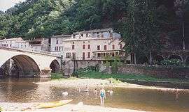 The Viaur at Laguépie. | |
| Country | France |
| Physical characteristics | |
| Main source |
Massif Central 1,070 m (3,510 ft) |
| River mouth |
Aveyron 44°8′39″N 1°58′1″E / 44.14417°N 1.96694°ECoordinates: 44°8′39″N 1°58′1″E / 44.14417°N 1.96694°E |
| Length | 168 km (104 mi) |
| Discharge |
|
| Basin features | |
| Progression | Aveyron→ Tarn→ Garonne→ Atlantic Ocean |
| Basin size | 1,530 km2 (590 sq mi) |
The Viaur is a 168 km long river in south-western France, left tributary of the Aveyron River. Its source is in the southern Massif Central, north of Millau. It flows generally west through the following départements and towns:
The Viaur flows into the Aveyron River in Laguépie.
Its main tributary is the Céor.
References
| Wikimedia Commons has media related to Viaur. |
This article is issued from
Wikipedia.
The text is licensed under Creative Commons - Attribution - Sharealike.
Additional terms may apply for the media files.