Vechoor
| Vechoor Kuda Vechoor | |
|---|---|
| village | |
 Vechoor Church Festival | |
| Coordinates: 9°40′0″N 76°25′0″E / 9.66667°N 76.41667°ECoordinates: 9°40′0″N 76°25′0″E / 9.66667°N 76.41667°E | |
| Country |
|
| State | Kerala |
| District | Kottayam |
| Population (2001) | |
| • Total | 16,830 |
| Languages | |
| • Official | Malayalam, English |
| Time zone | UTC+5:30 (IST) |
| Vehicle registration | KL- |
| Nearest city | Vaikom |
| Lok Sabha constituency | Kottayam |
| Vidhan Sabha constituency | Vaikom |
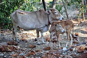
Vechoor is a village in Vaikom taluk, Kottayam district in the state of Kerala, India.[1] Vechoor is a short drive away from one of Kerala's tourist destinations, Kumarakom. The Vechur Cow breed of cattle is named after this village.[2]
Geography
Vechoor village covers a total area of 2,913 hectares. Vechoor is bordered by Vembanattu lake on the west and Kaipuzha river on south. Thanneermukkom Bund starts from Vechoor. Eastern part of vechoor is includes rice fields. There are many natural and man made canals in Vechoor which were used for water transport and irrigation.
Transport links
Till 1985, road connectivity to Vechoor was limited and bus services from Vaikom used to terminate at Vechoor. A road bridge alongside Thanneermukkom Bund connected Vechoor to Alleppey district in 1985. In 2003, Vechoor got connected directly to Kottayam via Kumarakom. Renovation of Kallara - Vechoor road added further connectivity. Vechoor is about 10 km from both the towns Vaikom and Cherthala. Kottayam and Alappuzha are about 20 kilometres away. There are regular bus services to all the towns. Bundroad junction is a major junction in the village where Vaikom - Vechoor road meets road to Cherthala. Kaippuzhamuttu is a bus hub where many bus services terminate.
A mega infrastructure road project is being planned through vechoor connecting Cherthala to Manarcaud [3]
Water transport
Swamikkallu boat jetty on western coast of vechoor used to have regular services connecting Ernakulam, Vaikom, Thanneermukkom, Mannanam and Kottayam. Also hand rowed boats were regularly used for transport of goods till end of the 20th century. However the improvement of road transport reduced the importance of inland water transport.
Railway station
The nearest railway station is Cherthala on Ernakulam-Kayamkulam coastal line which is 12 kilometers away. Cochin International Airport is 70 km away.
Education institutions
- Government.Devivilasam Higher secondary school
- St. Michael's Higher secondary school
- Govt. Highschool Vechoor (known as Perumana school)
- St. Mary's Lower Primary School
- St George Lower Primary School
- Hindi Premi Mandal of Dakshin Bharath Hindi Prachar Sabha (closed down)
N.S.S High school vechoor is not located in Vechoor despite the name.
Religious institutions
- Govindhapuram Sreekrishna Swami temple
- Sasthakkulam Devi Temple
- Poonkavu Devi Temple
- Ansarul Islam Juma Masjid Achinakom
- Cherakulangara Devi Temple
- Idayazham Subramanya Swami Temple
- Ansarul Islam Masjid Vechoor
- Muchoorkkavu temple
- Vaikundapuram Sreekrishna temple
- Vechoor Palli
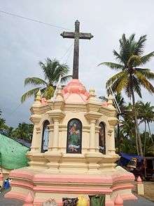
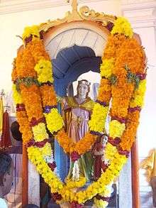
- St. Mary's Church
Notable personalities
- Vechoor Harihara Subramania Iyer, a Karnatic singer
- Harikrishnan, Malayalam film actor
- Vechoor Kunjan Panicker, Famous Thullal Artist.
- Vaikom Thankappan Pilla, Famous Kathakali Singer [Vaikom Brothers]
Demographics
As per 2011 census, Vechoor had a population of 17041 with 8,315 males and 8,726 females.[4] In 2001, Vechoor had a population of 16,830 with 8,305 males and 8,525 females.[1] After 2010, several migrant workers arrived in Vechoor particularly from West Bengal and Bihar
References
| Wikimedia Commons has media related to Vechoor. |
- 1 2 "Census of India : Villages with population 5000 & above". Registrar General & Census Commissioner, India. Retrieved 2008-12-10.
- ↑ "Holy Cow Small Packs a Big Punch". Newindianexpress.com. Retrieved 6 July 2018.
- ↑ Radhakrishnan, S. Anil (4 July 2015). "Govt. nod for 21 mega infrastructure projects". Thehindu.com. Retrieved 6 July 2018.
- ↑ "Census of India 2011 : KERALA" (PDF). Censusindia.gov.in. Retrieved 6 July 2018.